Alert
Alerts
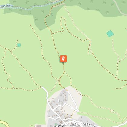
Descent from Les Orres via the County Town.

Description
A fun descent on which you can discover the joys of riding with views over the lake below, which you'll reach in no time.
Ascend the small road through the village from the church car park. At the first intersection after the fountain, turn right, staying on a small tarmac road. Follow the road towards Le Méale and Crévoux. The route continues along a track past a farm at the heights of the village. Follow the trail on a moderate slope overlooking Lake Serre-Ponçon. After a few hundred metres, the track enters a larch forest. The slope then steepens and becomes even steeper over a short stretch of concrete. After a hundred metres or so, the track is once more made of dirt and twists through the larch grove.
2.8 km from the start, the route passes through a car park in the woods, always taking the track over increasingly flat ground. The descent begins a few hundred metres after the car park. Don't miss the junction 50 m after the start of the descent at the sign for Les Graves sign. Turn left onto a single track and then right after 15m, staying on the single track. Join a wider path on the right and immediately turn left to pick up the trail once more. It then winds through the forest and emerges on a wider path at the end of the forest. Turn left and descend this path until you enter the forest once more. Immediately turn left onto a narrow path that soon leads back to a wide, stony track downhill.
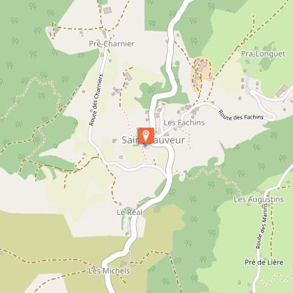
At the first hamlet of Saint-Sauveur, you return to the road. Take a footpath to the left at the first junction and follow the road downhill. Leave the hamlet and take the path on the right at the first bend. Turn left at the crossroads in the middle of the fields, staying on a wide path. After a few hundred metres, the path descends back to the road. Turn right through the village of Saint-Sauveur, then pass behind the church. A narrow path leaves the church car park and joins the road. Descend the road for 200 m and take a wide path on the left. Go straight ahead at the first junction, then right through the pines and right again on a narrower path 30 m further on. Head right after returning to a wider path, then left. Veer left again on a single track in the pine forest. Follow the track through the forest. After a long section of single track, turn left onto a wider path on a flat area. Cross the river and turn right just after onto the single track. Continue straight ahead on a wider path.
The path ends on a road. Turn right then left onto the departmental road. When you reach the main road, turn left and continue along this road. When you reach the Orres road, follow it down towards Embrun. At the roundabout, take the first exit and continue straight ahead. Then cross the cattle drive to reach the Entraigues shopping area. At the roundabout, go straight on towards the Durance to rejoin the path you took on the outward journey.
Technical Information
Altimetric profile
Starting point
Points of interest

Additional information
Public transport
Transports en commun : ccserreponcon.com
Advice
Restez vigilant et ralentissez dans la traversée de Saint-Sauveur.
Advised parking
Church car park, Les Orres County Town
Access
Follow the N94 from Gap or Embrun, then the D40 as far as Embrun to reach Les Orres. Finally, follow the signs for the "Chef-lieu”..
Arrival
Lake Embrun
Ambiance
At the start of the route, you can admire the lake from the heights of Les Orres. Once the descent begins, the landscape passes too quickly to pay much attention, but the nature of the terrain changes. The winding, root-clogged paths winding between the larches give way to dry, stone-paved paths in the heart of the pine forest, then narrow paths that disappear under the leaves of downy oaks lead you to the banks of the Durance..
Departure
Les Orres County Town.
Data author
