Alert
Alerts
360° walking tour over 2 days on the crests of Mont Jovet


IGN cards


Description
Set off to conquer the peaks of Mont Jovet and enjoy the incredible panoramic views from the top!
The 360° view offers a spectacular sight of the mountain ranges, including Mont Blanc! For the more adventurous, the sunrise is magnificent.
This walk is THE panoramic hike par excellence!
The starting point is the alpine village of La Cour with its traditional houses and summer tranquillity. The trail then climbs and winds through the Bois de la Cour forest lined with spruce and fir trees, where you can smell the scent of the conifer needles.
Once you have crossed the forest, you will come to beautiful meadows where our beautiful Tarine cows graze during the summer. Take the opportunity to listen to the sound of their bells and admire the mountain flora.
Once you arrive at the refuge, you can enjoy the dishes prepared by our couple of wardens and sample the local beers before settling down for a good night's sleep.
When tackling the ridges of Mont Jovet, it's best to get up early to enjoy the spectacle of Mother Nature and the sun rising over such a panorama! Never mind, we'll take a nap in the afternoon!
Once at the summit of Mont Jovet, admire the mountain range that lies before you: views of Mont Blanc, La Vanoise, Les Ecrins, etc.
You will continue along the Etroits ridge and then towards Roc du Bécoin, following a rollercoaster-like route. The rest of the trail descends towards the Vanoise glaciers, then through forest to the starting point.
Points of interest: A varied trail through forest, ridges and mountain pastures. The highest point of Mont Jovet offers a fabulous 360° panorama with its orientation table. This site is home to a wealth of wildlife (mouflons, chamois, marmots and numerous birds) and flora (gentians, lady's slippers, martagon lilies, etc.), but is also known geologically for its lustrous schists.
Access
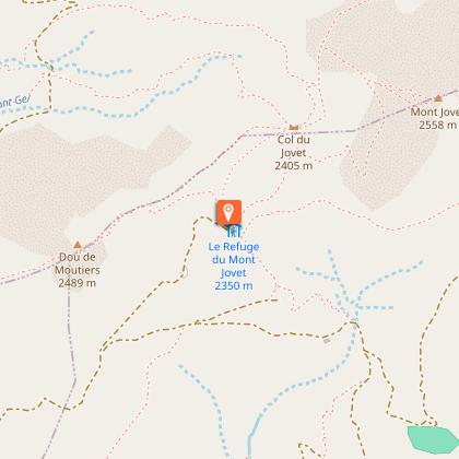
Start: La Cour
From the village, follow the uphill trail marked ‘Mont-Jovet’. Climb up through the Forêt de la Cour (a 10-minute detour is possible for a viewpoint at the top of the Grande Roche), then cross the pastures to the Mont-Jovet refuge. Climb to the summit (2,558 metres, orientation table).
The Chemin des Crêtes trail runs along the ridge of the massif, passing through the Pas des Brebis and the Roc du Bécoin, the highest point in the commune of Bozel (2,594 m), which the Bozelains called ‘Dou de l'Audience’. After the Bozelet chapel, go around Mont de la Guerre and descend towards the Porcière cross, where you will find the forest track towards Tincave. At a bend (picnic table), take the path (below the road) to Bonrieu and climb back up to La Praz and La Cour.
This route can also be done in reverse or from Tincave.
Technical Information
Altimetric profile
Starting point
Points of interest


Date and time
- From 15/07/2026 to 20/09/2026
Additional information
Updated by
Communauté de Communes Val Vanoise - Vallée de Bozel Tourisme - 29/12/2025
www.valleedebozel.com
Report a problem
Environments
Mountain view
Mountain location
Open period
From 15/07 to 20/09 daily.
Contact
Phone :
04 79 55 03 77
04 79 08 11 20
Email : info@valleedebozel.com
Website : http://www.valleedebozel.com
Facebook : https://fr-fr.facebook.com/ValleedeBozel/
Type of land
Ground
Not suitable for strollers
Tricky passages
Some difficult section on the crests.
Animals
Yes. Animals are permitted on the trail but not allowed in the refuge. Camping is permitted near the refuge.
