Alert
Alerts
Hiking route : La Poupée trail


IGN cards


Description
A short walk offering a lovely panorama of the valley
Technical Information
Altimetric profile
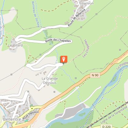
Starting point
Additional information
Environments
Forest location
Mountain view
Mountain location
Updated by
Office de Tourisme de la Grande Plagne - 06/08/2025
www.la-plagne.com
Report a problem
Open period
All year round daily.
According to snow cover.
Type of land
Stone
Ground
Hard coating (tar, cement, flooring)
Grit
Not suitable for strollers
Contact
Phone : 04 79 55 67 00
Email : info.vallee@la-plagne.com
Website : https://www.la-plagne.com/la-plagne-vallee
Reception complements
FOR YOUR PLEASURE AND SAFETY
Safety rules
• Check the weather forecast before you leave.
• Avoid going alone. Tell someone that you are leaving and your planned route.
• Don't forget to drink, eat and take breaks during the hike.
Equipment
• Wear good shoes and clothes that are suitable for the mountains.
• Take with you: sun cream, hat, sunglasses, warm clothes and rain gear, a mobile phone in case of problems.
• Take a map with you. This map is given as an indication, it does not replace the IGN maps.
Good conduct
• Stay on the marked paths and avoid mowed fields.
• Respect the environment.
• Watch out for herds of animals, keep your dog on a lead.
• Please take your rubbish away with you.
In case of accident: 112 or 18
Weather: 32 50
Guidebook with maps/step-by-step
0/ Set off from Bonconseil water tower.
1/ Follow the path to "Les Rottes".
2/ At the "Les Rottes" turn off, continue on the same path towards the bus stop and the road.
3/ To continue, take the road that goes down to Le Grange then Bellentre, or go up to Le Villard to join "Cyprien trail".
4/ Take the same path back.
Animals
Yes
Data author
