Alert
Alerts
Hiking route : Pont de la Barrieux trail

Description
A walk with mountain streams and forest scenery on the Versant du Soleil
A heritage route for St Grat and Bonvillard chapels.
Technical Information
Altimetric profile
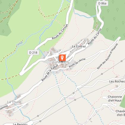
Starting point
Points of interest


Additional information
Environments
Riverside
Mountain view
Mountain location
Waterside
Updated by
Office de Tourisme de la Grande Plagne - 06/08/2025
www.la-plagne.com
Report a problem
Open period
From 01/01 to 31/12 daily.
Subject to weather conditions.
Type of land
Rock
Stone
Ground
Not suitable for strollers
Contact
Phone : 04 79 55 46 44
Email : info@sigranier.fr
Reception complements
FOR YOUR PLEASURE AND SAFETY
Safety rules
- Check the weather forecast before you leave.
- Avoid going alone. Let someone know that you are leaving and your planned route.
- Remember to drink, eat and take breaks throughout the hike.
Equipment
- Wear good shoes and suitable clothes for the mountains.
- Don't forget to take: sun cream, a hat/cap, sunglasses, warm clothes and rain wear, a mobile phone in case of problems.
- Take an IGN map with you. This map is given as an indication, it does not replace the IGN maps.
Best practices
- Stay on the marked paths and avoid the hayfields.
- Respect the environment.
- Watch out for animal herds, keep your dog on a lead.
- Take your litter with you.
In case of accident: ring 112 or 18
Weather forecast: 32 50
Guidebook with maps/step-by-step
0/ Set off from Granier following signs to "Côte d'Aime-Valezan".
1/ Pass in front of St Grat chapel, take the tarmac road to the left going towards "Bonvillard".
2/ At Bonvillard, go around the chapel and take the flat dirt road. At the wooden signpost marked "Pont de la Barrieux" go into the forest then walk up the path.
3/ At the chalet take the path to the left to "Pont Notaire", follow the dirt road then the tarmac road leaving a chalet and a rest area on your left.
4/ Leave the tarmac road to take the path that goes down to the left to Granier.
Animals
Yes
Data author
