Alert
Alerts
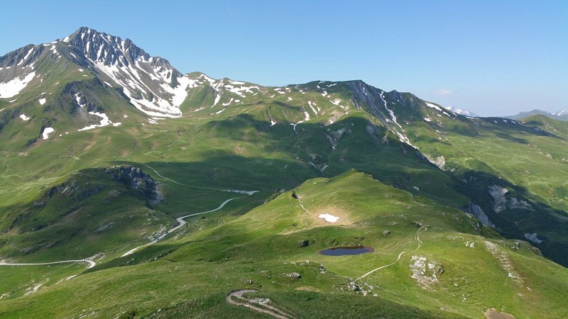
Hiking route : Tour de Falier trail
IGN cards


Description
Circuit trail around Plan Pichu mountain pastures with meadows and panoramic views
A botanical trail on part of the route is perfect for admiring the beauty of the mountain flora.
Technical Information
Altimetric profile
Starting point
Points of interest


Date and time
- From 01/05/2026 to 15/11/2026
Additional information
Environments
Riverside
Mountain view
Mountain location
Waterside
Updated by
Office de Tourisme de la Grande Plagne - 06/08/2025
www.la-plagne.com
Report a problem
Open period
From 01/05 to 15/11 daily.
Subject to weather conditions.
Type of land
Rock
Stone
Ground
Not suitable for strollers
Contact
Phone : 04 79 55 46 44
Email : info@sigranier.fr
Reception complements
FOR YOUR PLEASURE AND SAFETY
Safety rules
- Check the weather forecast before you leave.
- Avoid going alone. Let someone know that you are leaving and your planned route.
- Remember to drink, eat and take breaks throughout the hike.
Equipment
- Wear good shoes and suitable clothes for the mountains.
- Don't forget to take: sun cream, a hat/cap, sunglasses, warm clothes and rain gear, a mobile phone in case of problems.
- Take an IGN map with you. This map is given as an indication, it does not replace the IGN maps.
Best practices
- Stay on the marked paths and avoid the hayfields.
- Respect the environment.
- Watch out for animal herds, keep your dog on a lead.
- Take your rubbish away with you.
In case of accident: ring 112 or 18
Weather forecast: 32 50
Guidebook with maps/step-by-step
0/ Set off from the Laval or Pré Jeune car parks.
1/ Follow Tour du Beaufortain signs.
2/ Follow the track then the winding path to Col de la Pouprezaz.
3/ Continue towards Col du Cormet d'Arêches and La Coire refuge.
4/ Come back via Ste Marguerite's chapel and the waterfall.
Animals
Yes
Data author
