Alert
Alerts
The Puy de Dôme
Description
Climbing to the top of the Puy de Dôme brings a feeling of plenitude as you dominate the entire Puys chain and its 80 volcanoes. At the summit, the 2nd-century AD Temple de Mercure is one of the largest mountain sanctuaries in the Roman West.
Technical Information
Altimetric profile
Starting point
Steps

Additional information
Tips
- View to the left of Puy de Côme, Grand Suchet and Petit Suchet.
- View of the volcanoes and the Sancy massif.
Updated by
Conseil départemental du Puy-de-Dôme - 02/06/2026
www.puydedome-tourisme.com/
Report a problem
Environments
Mountain view
Mountain location
Presence of livestock and guard dogs
Distinctions
Listed PDIPR
Open period
From 01/01 to 31/12 daily.
Subject to favorable weather.
Location complements
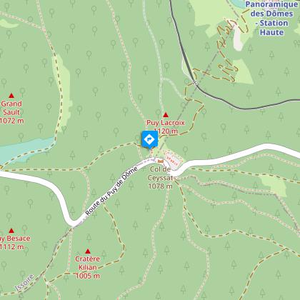
From Clermont-Ferrand, follow signs for Tulle on the D941 to Orcines, then the D942 to Puy de Dôme and Col de Ceyssat (parking lot). The start sign is 50 m above the parking lots behind the two restaurants.
Contact
Phone : 04 73 65 89 77
Email : infostourisme@auvergnevolcansancy.com
Facebook : https://www.facebook.com/auvergnevolcansancy/
Reception complements
For your own safety, always take a bottle of water, a hat, warm clothing and footwear suitable for walking.
Depending on weather conditions, certain itineraries are not recommended in bad weather (fog) or are not practicable, or even forbidden, during the winter season.
Some sites are fragile, so stay on the marked trails. Avoid picking wild flowers and disturbing wildlife. Pick up your garbage.
Animals are not allowed on some routes.
Guidebook with maps/step-by-step
1/ Opposite the start sign, turn left onto the gravel path. Continue under a canopy of beech and hazelnut trees to pastureland, which you cross (view to the left of Puy de Côme, Grand Suchet and Petit Suchet - caves). Continue to the crow's feet.
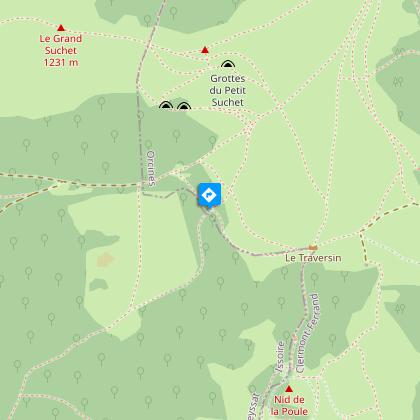
2/ Keep right and continue under the hazelnut trees to the intersection with the GR.
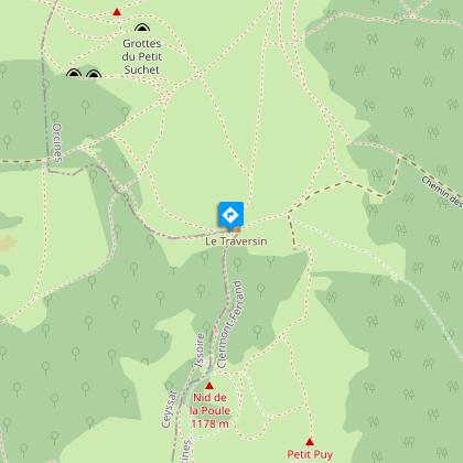
3/ Climb right towards the Traversin plateau to the fountain (1125 m).
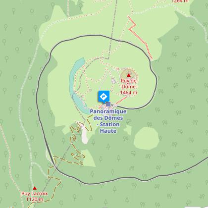
4/ Turn right, then climb steeply to reach a crossroads. Ignore the left-hand path and continue through heather and bilberry bushes to the foot of the stairs, which you climb. On the road, turn left and stay on the sidewalk to reach the site's platform and visitor center.
5/ Leaving it on the left, head downhill along the Chemin des Muletiers (to the south, views of the volcanoes and the Sancy massif). Cross the road and continue downhill to the parking lot.
Off the circuit: you can take the Chemin des Conquérants around the summit (orientation table) (approx. 30 minutes). On the west-facing slope, picnic area and washroom. You can then take the "chemin de ronde", which offers a 360° panorama, and return to the visitor center (approx. one hour).
Proposed and managed by the Conseil départemental du Puy-de-Dôme - PDIPR.
Animals
Yes. Dogs must be kept on a leash due to the presence of herds.
Data author
