Alert
Alerts
"Le Mont Jovet" (outward and return) from Notre Dame du Pré - 1 or 2 days

Description
From Notre-Dame-du-Pré (1 or 2 days), a challenging hike with an overnight stay in a refuge is possible.
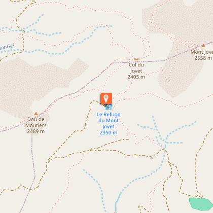
The trail winds up to Mont Jovet through alpine pastures grazed by herds of cows. Passage over the ridges before reaching the summit at 2558 m.
"Mont Jovet (return journey from Notre Dame du Pré)
The most courageous can climb to the summit of Mont Jovet (2558 m), 30 minutes from the refuge.
On arrival, an exceptional 360° panorama with views of Mont Blanc, the Ecrins, the Matterhorn, the Dômes de la Vanoise, the Beaufortain...
Further down, after a 30-minute walk, you'll find the Mont Jovet refuge and its restaurant. Let yourself be tempted by a delicious, well-deserved meal on the terrace. Enjoy the incredible views and soothing calm.
SINGLE ROUTE :
Start: "La Grange à Marc" (1818 m) - approx. 2 km after the Glaisy campsite, following the road.
Length: 6.3 km one way (Mont Jovet summit then Mont Jovet refuge)
Duration: 3 hrs.
D+: 881 m / D-: 360 m
Departure altitude: 1818 m
Arrival altitude: 2528 m
Difficulty: difficult
GO / RETURN
1st option (Return by the same route)
Departure point: Mont Jovet refuge
Distance : 12 km
Time : 6h00
D+ : 1030 m
D-: 1030 m
Departure altitude: 1818 m
Finish altitude: 2528 m
Difficulty: difficult6
2nd option:
If you'd like to do a loop on the way back, allow around 5 km more than on the Aller retour itinerary. You'll pass through the Combe d'Aigue chalet and the Côte chalet to "Plan Sapey". Return to the parking lot at "La Grange à Marc".
Technical Information
Altimetric profile
Starting point
Points of interest

Date and time
- From 31/05/2026 to 31/10/2026
- From 31/05/2027 to 31/10/2027
Additional information
Environments
Mountain location
Updated by
Coeur de Tarentaise Tourisme - 26/01/2026
www.coeurdetarentaise-tourisme.com/
Report a problem
Open period
From 31/05 to 31/10.
Subject to favorable snow and weather conditions.
Contact
Phone : 0479042905
Email : tourisme@coeurdetarentaise.fr
Website : https://www.coeurdetarentaise-tourisme.com/
Facebook : https://www.facebook.com/CoeurdeTarentaisetourisme
Location complements
1/ From Albertville, take the RN90 to Moutiers,
2/ Moûtiers towards Bourg St-Maurice, take the Les Plaines and Notre-Dame du Pré exit.
3/ Go through the village of Notre-Dame du Pré and turn right at "Rocher d'escalade" and "Mont Jovet".
4/ Continue towards Camping du Glaisy, along the forest road.
5/ After the campsite, continue for approx. 2 km to the parking lot at "La Grange à Marc" (1822 m).
Guidebook with maps/step-by-step
Day 1 Departure point: "Parking de la Grange à Marc (1822 m) 1/ Take the forest road to the chalet de Plan Sapey (1850m). 2/ Shortly before the intersection, take the path that climbs to the left towards the Halle de Fruit Commun and continue along this path. 3/ Then take the alpine pasture track towards Chalet la Raynaud (2103 m). 4/ Further up, leave the track and take the path leading to the Col du Mont Jovet. The climb takes you through a small combe, skirting a small stream. 5/ Back on the road above, continue (east) towards the Col du Mont Jovet on the path. 6/ At the Mont Jovet pass, signposted (2404 m), follow the path down to the Mont Jovet refuge behind the pass (approx. 20 minutes' descent) on the south-west side, or continue along the ridge to Mont Jovet, Signal (2558 m).
Overnight stay at the refuge
Return by the same route
Animals
Yes. Pets welcome
Data author
