Alert
Alerts
Piédestal de Fontaneilles


Description
Come and explore the Pedestal of Fontaneilles, a medieval fortress built on a rocky peak, dominating the valley and offering a 360° panorama.Leave the parking and go up to the castle, then follow the path on the right that goes along the ramparts, on 400 m.Get on the path that rises on the left. on 100 m, stay on the path on your right. It goes up in undergrowth, reaches the wooded plateau of the Puech de Fontaneilles and ends up on a forest path.Make a round trip on the right to gain in 300m, the television antenna and enjoy the sight on thr valley of Trébans and the village of Bourg. Retrace your steps and continue straight ahead on the forest path to arrive at a junction.On the left side, go towards the Pedestral, about 400m. View on the valley of the Tarn, the village of Rivière-sur-Tarn and the hamlet of Caylus perched on the hill on the opposite side. Retrace your steps and come down by taking the forest track in wide laces. Once crossing the gate, go along on 100m and foward on the little path on the left. It leads to Fontaneilles, at a big farm.Get on the left path, 500m after yhe wooden barrier. Keep this track until the road which leads to Col. Follow the signage until the cellars of Entre-deux-Monts.Retrace your steps until finding the path common to an entrance of a field. Follow it until reaching the road of Fontaneilles. Go up on the left and take on right site 200m further to come towards the village.Return on the road and go down until Fontaneilles and cross the village. After the church, take the second street on the left. At the crossing out of stones, follow the path that passes bellow an agricultural shed which continues until Louradou.At the crossing of Louradou, take the path going up to the hamlet of Peyrelade. Take time to discover the castle, a fortress of the 12th century, which the visit allows you to retrace the time of the Lords of Rouergue.
Technical Information
Altimetric profile
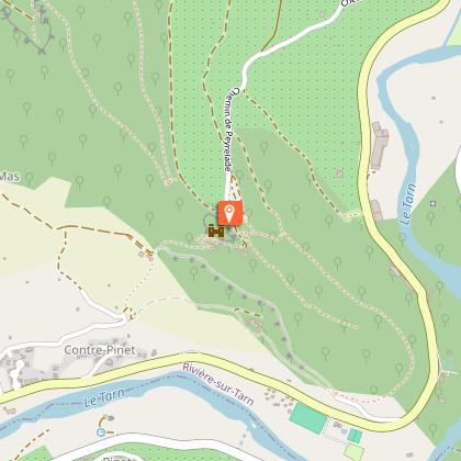
Starting point
Steps
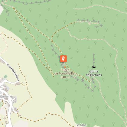
Points of interest


Additional information
Public transport
Pensez au covoiturage et à l'autostop Rezopouce ; Aires de covoiturage
Advised parking
Parking du château de Peyrelade
Access
(By the D809 and the D907, 15 km from Millau) At the entrance of the village Boyne ,a street on the left that goes up to the castle of Peyrelade.
Ambiance
By traveling the north then south hillsides of the Puech de Fontaneilles (witness of the Grands Causses geologie), discover a rich heritage full of history: the castle of Peyrelade, the mysterious Pedestal and also the village of the wine cellars d'Entre-deux-Monts (not to be missed).
Departure
From the Castle of Peyrelade
Data author
