Alert
Alerts
Cascade de Pont Ferrand - Hike from Le Perron (Clavans-en-haut-Oisans)
1 alert on this circuit
Alerte visiteurs
Itinéraire potentiellement soumis à de forts dégâts dus à des évènements météorologiques majeurs et dont la viabilité peut être incertaine, renseignez-vous avant de vous engager sur ce parcours.


IGN cards


Description
From the hamlet of Le Perron, it's a short family hike along a wide path to the waterfalls. If your calves are up to it, climb above one of the waterfalls. It's steep, but beautiful!
This walk at the foot of the Pont Ferrand waterfalls is also a good excuse to spend the day discovering the villages of Clavans-en-Haut-Oisans, the mountain pastures of the Ferrand valley and the Col de Sarenne.
TECHNICAL INFORMATION
Start: Clavans-en-Haut-Oisans, hameau du Perron
Difference in altitude: 105 m
Round trip time: 50 min
Round trip distance: 2 km
Level: easy
MAP AND TOPO
IGN TOP 25 map no. 3335 ET - Bourg d'Oisans, Alpe d'Huez
OBP map n°3 (Oisans au Bout des Pieds), trail 337
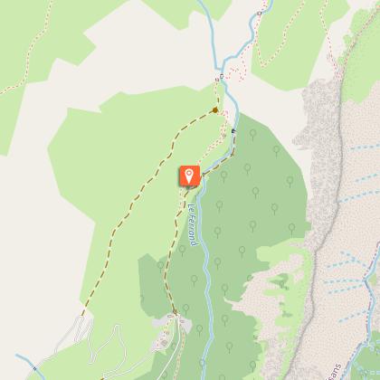
ROUTE :
From the hamlet of Le Perron, follow the trail around the hairpin bend.
Halfway along (after 500 m), a path begins on your left: leave the track and take this path. Just before you reach the waterfalls, you'll come to another track: turn right. The path descends more steeply and you'll have to cross a stream to get to the Ferrand bridge, from where you can admire the waterfalls. The one on the left comes from the Pisserote stream, the one on the right from the Ferrand torrent.
The glacial waters flowing forcefully past you will join the Romanche river a little further down the valley.
You can also follow the path up to the top of the Ferrand waterfall, if you feel like it (caution: overhanging path).
THINGS TO SEE ALONG THE WAY
- The storied hamlets of Clavans-en-Haut-Oisans
- The unique landscape of the Col de Sarenne high-altitude mountain pastures, with views of the Écrins and Grandes Rousses.
NEARBY ATTRACTIONS
Pont Ferrand is the starting point for an emblematic Oisans hike: to Lac des Quirlies.
This glacial lake, created by the retreat of the glacier of the same name, is the most recent addition to the Oisans region!
This hike is for experienced walkers only: 7 km, 1,000 m ascent, 4 h climb.
But the journey is well worth the effort!
Technical Information
Altimetric profile
Starting point
Additional information
Updated by
Oisans Tourisme - 19/11/2025
www.bike-oisans.com
Report a problem
Environments
Mountain view
Panoramic view
Waterfall view
Open period
From 01/05 to 31/10 daily.
Subject to favorable snow and weather conditions.
Contact
Phone : 04 76 80 00 85
Email : info-ferrand@oisans.com
Website : https://www.oisans.com/loisans/stations-et-villages/besse/
Topo guides and map references
Topo guides references :
OBP map no. 3 (Oisans au Bout des Pieds), trail 337
Map references :
IGN TOP 25 3335 ET
Type of land
Ground
Grit
Not suitable for strollers
Location complements
Roadside parking on the bend and upstream.
Animals
Yes
Data author
