Alert

Alerts

To see around
See more
Open
Close
Show
Show
Show
Show
Show
Show
Show
Show
Show
Show
Show

Oups... It would appear that Cirkwi does not have permission to use your location.

Presentation
Description
Map
Points of interest
Ratings and reviews
See around

Gorges de Sarenne en boucle - Hiking

Gorges de Sarenne en boucle - Hiking

IGN cards

3335ETR - LE BOURG-D'OISANS L'ALPE D'HUEZ RESISTANTE GRANDES ROUSSES SEPT LAUX
Editor : IGN
Collection : TOP 25 RÉSISTANTE
Scale : 1:25 000
17.20€
3336ETR - LES DEUX ALPES RESISTANTE OLAN MUZELLE PARC NATIONAL DES ÉCRINS
Editor : IGN
Collection : TOP 25 RÉSISTANTE
Scale : 1:25 000
17.20€
3335ET - LE BOURG-D'OISANS L'ALPE D'HUEZ GRANDES ROUSSES SEPT LAUX
Editor : IGN
Collection : TOP 25 ET SÉRIE BLEUE
Scale : 1:25 000
13.90€
3336ET - LES DEUX ALPES OLAN MUZELLE PARC NATIONAL DES ÉCRINS
Editor : IGN
Collection : TOP 25 ET SÉRIE BLEUE
Scale : 1:25 000
13.90€
TOP75006 - MASSIF DES ECRINS OISANS CHAMPSAUR
Editor : IGN
Collection : TOP 75
Scale : 1:75 000
9.80€
TOP100D38 - ISÈRE GRENOBLE VIENNE PARC NATIONAL DES ÉCRINS PARC NATUREL RÉGIONAL DU VERCORS
Editor : IGN
Collection : TOP 100
Scale : 1:100 000
8.40€
TOP100D73 - SAVOIE CHAMBÉRY ALBERTVILLE PARC NATIONAL DE LA VANOISE PNR DU MASSIF DES BAUGES
Editor : IGN
Collection : TOP 100
Scale : 1:100 000
8.40€
202 JURA ALPES DU NORD
Editor : IGN
Collection : TOP 200
Scale : 1:200 000
6.80€
D04-05 ALPES-DE-HAUTE-PROVENCE HAUTES-ALPES
Editor : IGN
Collection : CARTES DÉPARTEMENTALES IGN
Scale : 1:150 000
5.90€
D38 ISÈRE
Editor : IGN
Collection : CARTES DÉPARTEMENTALES IGN
Scale : 1:150 000
5.90€
NR14 AUVERGNE-RHÔNE-ALPES RECTO/VERSO MASSIF CENTRAL
Editor : IGN
Collection : CARTES RÉGIONALES IGN
Scale : 1:250 000
6.80€
NR16 PROVENCE-ALPES-CÔTE D'AZUR
Editor : IGN
Collection : CARTES RÉGIONALES IGN
Scale : 1:250 000
6.80€
NR15 AUVERGNE-RHÔNE-ALPES RECTO/VERSO MASSIF ALPIN
Editor : IGN
Collection : CARTES RÉGIONALES IGN
Scale : 1:250 000
6.80€
EUROPE
Editor : IGN
Collection : DÉCOUVERTE DES PAYS DU MONDE IGN
Scale : 1:2 500 000
7.00€

Description

A beautiful hike that takes you through the Sarenne gorges and up the slopes of Signal de l'Homme. You'll also pass through the charming hamlet of Rosai, which is well worth a visit.

TECHNICAL INFORMATION
Start: Auris-en-Oisans
Height difference: 560 m
Round trip time: 5h
Distance : 12.5 km

MAP AND TOPO :
Map / Topo guide OBP n°2 et 3 (on sale at the tourist office): paths 301 + 290 + 265 + 252 + 339 + 253.

ITINERARY
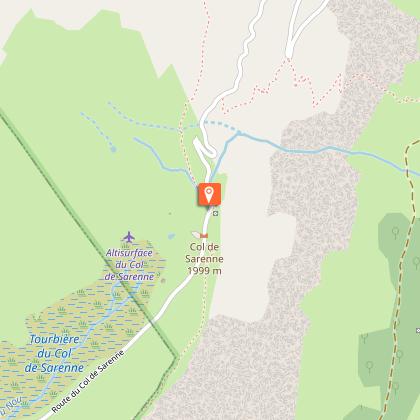
At the entrance to the resort, take the path up towards the Col de Maronne. At the top, head down towards La Garde, then the Col de Sarenne.
You'll come to the mountain hamlet of Le Rosay, then cross the Sarenne by the Roman bridge 1 km further on. Continue towards Col de Sarenne on a pretty, gently sloping path that runs alongside the torrent of the same name.
At Le Gua, take the path up to Col de Cluy. Then follow the signs for Col de Maronne to get around Signal de l'Homme (Aurienchon summit). This 2.5 km trail is easy to follow. The added bonus: panoramic views of the Belledonne, Taillefer and Écrins ranges as you go.
At the Col de Maronne, return downhill to the resort of Auris-en-Oisans, with a view of the 2 Alpes glacier.

THINGS TO SEE ALONG THE WAY
- The hamlet of Le Rosay, with its typical Oisans stone houses and 15th-century chapel de la Ste Trinité, has a mountain charm all of its own.
- The Pont Romain, aptly named, marks the crossing of an ancient "Roman road" that linked Grenoble to Italy via the Col du Lautaret and the Romanche valley.
- The old Sarenne mill, on the banks of the torrent of the same name, with its remains and explanatory panels.

THINGS TO SEE AND DO NEARBY
Discover the botanical garden on path 252, towards the Col de Sarenne.

THINGS TO KNOW
La Sarenne, "the longest black run in the world". In fact, the path you're taking is the end of this legendary ski run in winter.

Dogs must be kept on a leash because of the presence of herding dogs at certain times of the year.

Technical Information

Walking
Difficulty
Medium
Duration
5h
Dist.
12 km
Show more

Altimetric profile

Starting point

Place des Orgières , 38142   Auris-en-Oisans
Lat : 45.055985Lng : 6.077809

Points of interest

image du object

The Sarenne round trip (Circuit n°8)

Reaching Alpe d’Huez involves tackling the 21 famous switchbacks known to cyclists the world over. Climbing to the top by car is less of a problem, and you are sure to arrive in better shape at the summit!This almost 47 km circuit start in Bourg d'Oisans. This route takes you first to the centre of the resort, where ↘two exhibitions await. The first unveils details of the lives of the inhabitants of Brandes, a small village that grew around the silver mines operating from the mid-12th century to the mid-14th century for the profit of the ‘Dauphin’, the Lord of the Dauphiné region. The museum displays the findings of the archaeological digs that have been carried out on this site for the past 35 years. The second exhibition, entitled ‘Local people, living in Oisans in the old days’ (Gens d’ici, vivre en Oisans autrefois), focuses on key themes, guiding visitors along a trail which takes them deep into the daily lives of Oisans inhabitants, from birth through to death: rites and beliefs, peddling, wakes…everything that forms the core of a mountain society. A new exhibition: "Ready for sport" depicting how Alpe d’Huez gradually became the sports resort, we know today. A short step from the museum, next to the altiport, you can see the ↘Brandes silver mine, a unique archaeological site in Europe. Guided visits are organised twice a week. You can then carry on up to the ↘col de Sarenne for a magnificent view over the Emparis plateau. After the pass, you find yourself in the Ferrand valley, with its string of villages: Clavans-en-Haut‑Oisans, Besse-en-Oisans and Mizoen. Give your legs a stretch by strolling peacefully through the streets of these pretty villages. Before returning to Bourg-d'Oisans, stop off at Freney d’Oisans. A Route des Savoir-Faire member will welcome you to his work place and show you his skill. Gilles, a passionate beekeeper, offers «Bee Safari» adventures going from hive to hive dressed in beekeeping gear (please phone ahead). You can explore his ↘"Un Ecrin de miel" smallholding and taste his delicious produce, including mountain honey and other regionally produced honeys, propolis, gingerbread and nougat.

- Oisans Tourisme -
Consulter

Date and time

  • From 15/05/2025 to 31/10/2025
  • From 15/05/2026 to 31/10/2026

Additional information

Updated by

Oisans Tourisme - 07/10/2024
www.oisans.com
Report a problem

Open period

From 15/05 to 31/10.

Subject to favorable snow and weather conditions.

Contact

Phone : 04 76 80 13 52

Email : info-auris@oisans.com

Website : www.auris.fr

Facebook : www.facebook.com/aurisenoisans/

Type of land

Ground
Grit

Topo guides and map references

Topo guides references :
Map / Topo guide OBP n°2 (on sale at the tourist office): trails 301 + 290 + 265 + 252 + 339 + 253.

Map references :
IGN Top 25 Bourg d'Oisans et l'Alpe d'Huez 3335 ET.

Data author

Image Oisans Tourisme
proposed by Oisans Tourisme
1 bis rue Humbert 38520 Le Bourg d'Oisans France

Ratings and reviews

To see around
See more
Open
Close
Show
Show
Show
Show
Show
Show
Show
Show
Show
Show
Show
Caution!
We have no information on the difficulty of this circuit. You may encounter some surprises along the way. Before you go, please feel free to inquire more and take all necessary precautions. Have a good trip! 🌳🥾