Alert
Alerts
Cascade de la Pisse - Walk from Le Bourg-d'Oisans
1 alert on this circuit
Alerte visiteurs
Itinéraire potentiellement soumis à de forts dégâts dus à des évènements météorologiques majeurs et dont la viabilité peut être incertaine, renseignez-vous avant de vous engager sur ce parcours.
IGN cards


Description
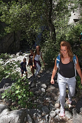
A quiet, bucolic walk at the foot of the cliff, in the sun in the morning and in the shade in the afternoon. An almost flat itinerary, except for the last section which climbs to the waterfall on a footpath.
TECHNICAL INFORMATION
Start: Bourg-d'Oisans town hall - 700 m altitude
Difference in altitude: 70 m
Round trip duration: 1h30 one way and 1h30 return
Round trip distance: 10.4 km
Difficulty: very easy
MAP AND TOPO
Top 25 IGN 3335 ET Bourg-d'Oisans, Alpe d'Huez
OBP (l'Oisans au Bout des Pieds) map no. 1, trail 657 (available from the tourist office).
ITINERARY
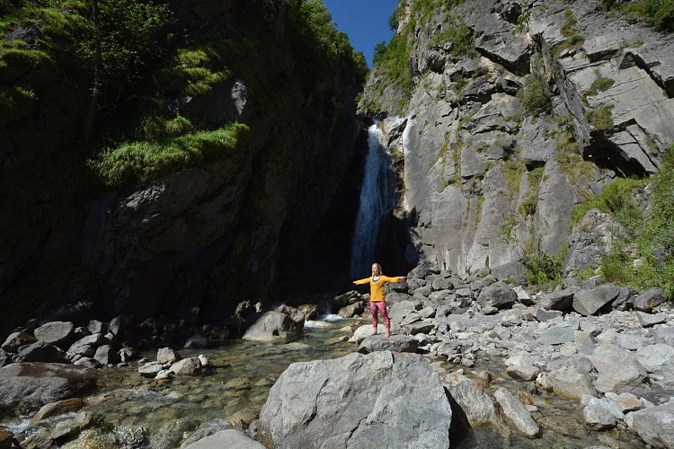
This easy stroll through the valley is recommended for families and light walkers. The waterfall is a perfect excuse for a cool picnic and to take advantage of the various watering holes during the hot summer months. An itinerary that reveals the hidden face of the Romanche plain and the banks of the Vénéon.
In Le Bourg-d'Oisans, join the park in front of the town hall. Between the town hall and the church, follow rue Humbert in the direction of "Villard-Notre-Dame". At the end, take the left-hand road "chemin de St-Claude", not the right-hand road which climbs up to the village of Villard-Notre-Dame (a must-see! but take the car... The balcony road is narrow and suspended, a typical Oisans journey).
For 2 km you'll follow a tarmac road, then for a more natural itinerary look out for a path on the right that joins the road a little further on. Once you've reached the sources de la Rive, the starting point for canoe and paddle trips on the peaceful Rive that runs through Le Bourg-d'Oisans, the itinerary is now pedestrianized. But that's not all: you're on the voie verte (hence the tarmac), so many non-motorized machines share the area with you.
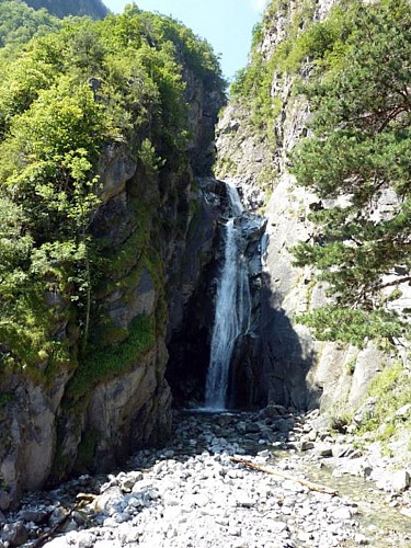
From here, follow the cliff on your right to the waterfall. You then leave the voie verte to follow the signs for "cascade de la Pisse", which go up to the right along a path.
Return by the same route, with a detour to Lac de Buclet to soak up its luminous turquoise blue!
THINGS TO SEE ALONG THE WAY
- the Mairie park and its bucolic little pond
- the church and the Museum of Fauna and Minerals
- the blue lake and picnic area.
- Buclet lake
- the Pisse waterfall
- the vast bed of the Vénéon and its Siberian allure
Technical Information
Altimetric profile
Starting point
Additional information
Environments
Forest location
Waterside
Lake 5 km away
Close to a public transportation
Updated by
Oisans Tourisme - 15/10/2025
www.bike-oisans.com
Report a problem
Open period
From 01/04 to 31/10 daily.
Subject to favorable snow and weather conditions.
Contact
Phone : 04 76 80 03 25
Email : info-bourgdoisans@oisans.com
Website : https://www.bourgdoisans.com/
Location complements
Starts from the centre of Bourg d'Oisans: bus stop " office de tourisme" bus line T75, T70, T73, T75, T76, T77
Animals
Yes
Data author
