Alert
Alerts
Arêches-Boudin loop


Description
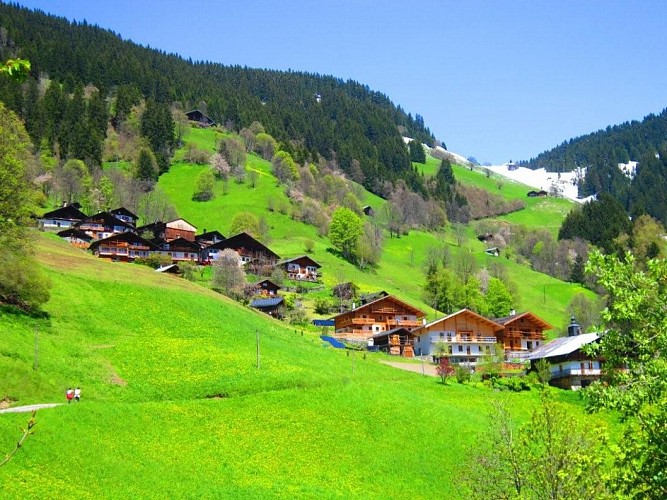
This loop starts in the village to reach the famous village of Boudin and its chapel, before going down through the Crêt-Gérel, where the view is remarkable on the rooftops of the village of Arêches and the Planay valley.
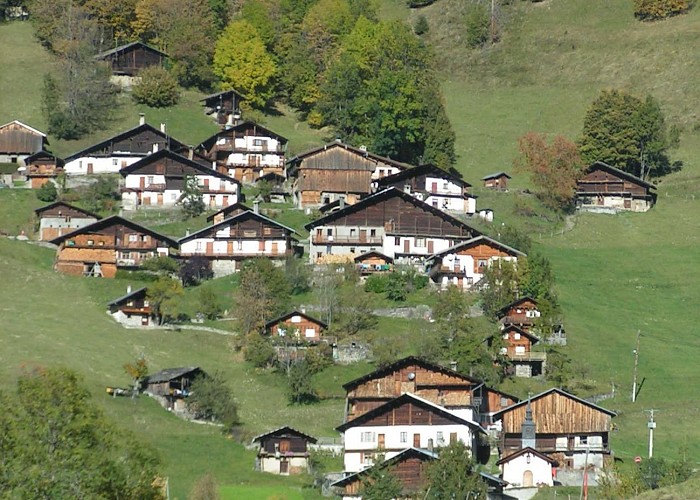
The Hamlet of Boudin with its chapel dedicated to Saint Jacques, is registered as a protected site since 1943 and some of its chalets are listed in the heritage inventory, installed on a steep slope between 1230m and 1380m. Formerly the hamlets of Beaufortain lived isolated especially in winter. Life was then organized around several poles, which are the trough, the bread oven, the school and the chapel. This hamlet was marked by 2 violent fires, one in 1962 which destroyed 2 houses in the central part (small cottages replaced them, and the other in 2010 which destroyed 3 houses in the lower part, all three rebuilt. From this hamlet, one can observe a nice panorama on the valley of Arêches.
By etymology, Boudin might have taken his name from a former resident : Jean Boudin who lived in the village at the end of the 14th century. Or then it is said that Boudin was founded by a burgonde named Baldwin who would have given Baldinus or Boldinus. He would have founded a villa (farm): the villa Baldina became with the evolution Boldin then Boudin.
Technical Information
Altimetric profile
Starting point
Date and time
- From 01/05/2026 to 31/10/2026
Additional information
Updated by
Office de Tourisme d'Arêches-Beaufort - 04/09/2025
www.areches-beaufort.com
Report a problem
Environments
Mountain view
Mountain location
Location complements
Park in Arêches, the route begins in front of the church, to the left of the newsagent
Open period
From 01/05 to 31/10.
Subject to favorable snow and weather conditions.
Type of land
Ground
Hard coating (tar, cement, flooring)
Contact
Phone : 00 33 04 79 38 15 33
Email : info@areches-beaufort.com
Website : http://www.areches-beaufort.com/
Guidebook with maps/step-by-step
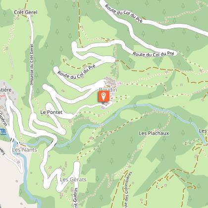
0/ Start: Place du Cadran solaire in front of the church
1/ Take the Chemin des Soeurs to the intersection of the Route de Saint Guérin.
2/ Take the path of the waterfall that passes next to the wash house and the chapel of Ameïs and along the stream of Poncellamont.
3/ at Lieu dit la Barme, take the path that indicates Boudin and passes through the Pontet by taking the Crêt Gérel road for a few meters.
4/ from the sign (yellow) which indicates the Pontet, continue the path then the road to the top of the village of Boudin
5/ go down the same path to the Crêt-Gérel road.
6/ Drive up to Crêt Gerel.
7/ Go down to Arêches by the path.
Animals
Yes
Data author
