Alert
Alerts
Sommet des Monges (from the Monges lake)


Description
The highest point in the Provence Highlands. This must-do hike—which is accessible despite a pleasant but steep climb—rewards you with a breathtaking 360-degree panorama: from the peaks of Sainte Victoire and Mont Ventoux to the Mercantour and Oisans mountain ranges!
From the parking lot, go through the ONF gate and follow the trail for 400 m to Lac des Monges.
From Lac des Monges (1,544 m), follow the forest trail to the left until you reach the hamlet known as “Le Pradon.”
At the “Le Pradon” junction, continue along the trail on the right, staying in the forest, until it ends.
At the end of the trail, continue along the path that winds through the larch forest. Upon exiting the forest, a long traverse across the slope below the summit of Coste Belle leads to the Raus ridge.
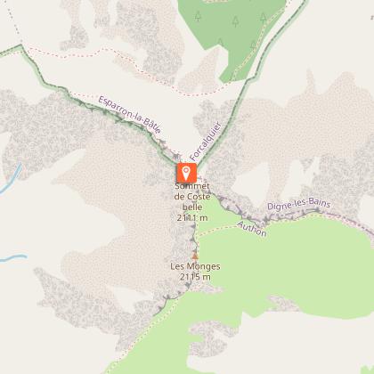
From the Raus ridge (1,892 m), take a steep trail to reach the summit of Coste Belle and its orientation markers.
At Coste Belle (2,106 m), the trail continues along the ridge (entering a pasture guarded by Patou sheepdogs) to the summit of Les Monges.
From the summit of Les Monges (2,115 m), head due east (no trail) and follow the markers while staying on the ridge. From a final outcrop, descend directly down a very steep grassy slope to the Col de la Croix de Veyre.
At the Col de la Croix de Veyre (1,886 m), join the GR®6 and follow it north to the Col de Clapouse.
At the Col de Clapouse (1,692 m), follow the GR®6 toward Le Pradon through pastures and forest. Finally, rejoin the ascent route and follow it in the opposite direction to return to the starting point.
Technical Information
Altimetric profile
Starting point
Points of interest


Additional information
Public transport
Let’s limit our trips and use public transportation and carpooling: zou.maregionsud.fr
Advice
WARNING: On this route, you may encounter livestock guard dogs protecting herds from wolf attacks.It is strongly discouraged to bring a pet dog, even if it is on a leash.If you encounter a herd, stay calm: stop, let the guard dogs get a good look at you, then give the herd a wide berth without making any sudden movements.→ To learn the proper precautions to take when encountering guard dogs, visit: rando.sisteron-alpesprovencales.fr/information/14-les-patous-et-nous-! 2 must-see orientation tables at the summit The ascent begins in a forest and then continues along an exposed ridge—proceed with caution! The pasture at Coste Belle is guarded by Patou dogs—proceed with caution. This route crosses the Haute-Provence Geological Nature Reserve (a protected natural area).
Advised parking
Monges lake parking lot, Bayons
Access
From Sisteron (39 km), take the D951, then just before La-Motte-du-Caire, follow the D1 toward Clamensane and on to Lac des Monges.
Arrival
Monges lake, Bayons
Ambiance
Departure
Monges lake, Bayons
Data author
