Alert
Alerts
Plaine des Bessons


Description
A very pleasant walk at the foot of Rocher Saint Michel, offering views of Orpierre and its cliffs.
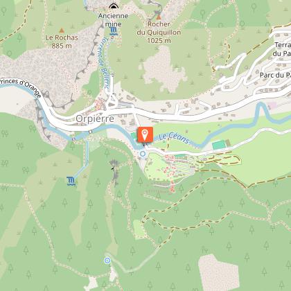
From the fountain in the village square, follow Route D 30 toward Laragne, then take the small road toward the Camping des Princes d'Orange. After the bridge, head back up the main road that runs alongside the campground. Continue along the trail until you reach a fork.
Take the right fork onto the main trail. Pass in front of the old Paturle farm; ignore the trail branching off to the right and continue uphill to a second fork.
At the signpost marked “Au-dessus de Paturle,” take the left trail toward “Saint Michel via the Plaine des Bessons” (yellow markers). Be careful: the shaded trail climbs quite steeply for 300 meters.
At the next fork, head down the path straight ahead toward “Orpierre via Plaine des Bessons – 2.8 km.” Cross the wooded plain, then follow the path downhill to the trail.
Return to the church square via the same route you took on the way up.
Technical Information
Altimetric profile
Starting point
Additional information
Public transport
Let’s limit our trips and use public transportation and carpooling: zou.maregionsud.fr
Advice
A longer, more challenging version of the hike is available via a scenic overlook: Meet at the “Rocher Saint-Michel” trail (rando.sisteron-buech.fr) Explore Orpierre, the village that climbs (www.orpierre-escalade.com)
Advised parking
Church's parking lot, Orpierre
Access
From Laragne (13 km), take the D 1075, then the D 30 (Eyguians/Pont-Lagrand junction) to reach the town of Orpierre.
Arrival
Church's place, Orpierre
Departure
Church's place, Orpierre
Data author
