Alert
Alerts
Entre Monts et Merveilles


Description
Diversified and disorienting, this hiking will make you go through rural paths, beech forest, limestone cliff, pastures… You will also have the honour to walk onto the former door-to-door salesmen pathway – which used to link Serres to La Drôme
Go up the Sigottier road until La Montagne hamlet (977 meters). From the hamlet, hike up the valley on the same road (for about 1,5 km) and then take a path ending into a forest one.
Once the Pied du Duffre reached (1447 meters), on a lawn strewn with Scots pine, take the path on your left towards Arron’s pass.
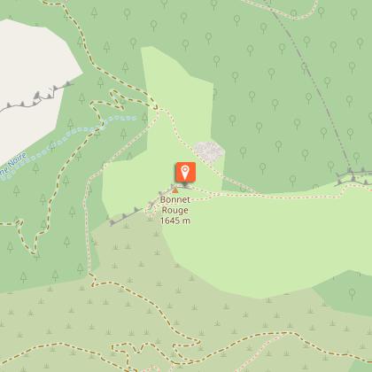
From the pass, you can reach the Duffre summit (1h30 return trip) by crossing through the pastures (2,4 km and 300 meters slope). Take the left path (towards “Le bonnet Rouge”) which pass nearby a sheepfold and reach the Saute pass. At the Saute pass (1499 meters), follow the main track which lands on a wide bend until the Pré pass (indicated “col de Champlat”, 1501 meters). At the Pré pass (or “col de Champlat”), leave the track and turn left in a small pasture. 50 meters further, turn right and cross a small wood. A path alongside the mountain ridge bypasses the Bonnet Rouge summit on the left and reaches Champlat.
From Champlat, a return trip allows you to reach the summit (1645 meters) by following the ridge on the right (1 km and 60 meters slope). Follow the long Serre de la Bouisse ridges. The path ends up between box trees’ heaths and the limestone pavement to reach Jardanne rock (1359 meters.)
At the Jardanne rock, turn left and go down a beech forest until the Ollagnier source.
At the source, follow an undergrowth path on the right leading to Saumane pass.
At the pass, turn left on a wide path leading to the Michons. Cross the hamlet and go down the single track until the departure point.
Technical Information
Altimetric profile
Starting point
Points of interest
Additional information
Public transport
Let’s limit our trips and use public transportation and carpooling: zou.maregionsud.fr
Advice
Sigottier village and its rock-climbing site visits on www.sisteron-buech.fr From Arron pass, you can reach Duffre summit in an hour and a half (return trip) by crossing through the pastures. (2,4 km and 300 meters slope). From Champlat, a return trip allows you to reach the Bonnet rouge summit (1645 meters) by following the ridge on the right (1 km and 60 meters slope.)
Advised parking
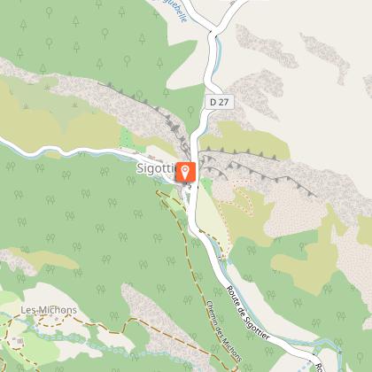
Rock-climbing site parking lot in Sigottier.
Access
From Laragne (20 km), take the departmental road D 1075 towards Gap. Just before the bridge take the departmental road D 27 until Sigottier.
Arrival
Parking lot at the climbing site, 250 meters before Sigottier
Departure
Parking lot at the climbing site, 250 meters before Sigottier
Data author
