Alert
Alerts
Crêtes de Raton (N°1)


Description
A particulary eye-catching path which offers a panoramic view on Le Rosanais and L’Oule valleys. La crête de Raton is a very privileged place where chamois can be observed. It is a quite athletic trail but it is worth the effort !
The Raton’s hamlet (716 meters) where rapid streams water flows into is located at the south of the dell. It is also the place where the Baudon river starts and it is related to the Eygues river. From the hamlet, take the left path and start a long climb up. This path was the old access to those houses which are only ruins now.
Once the Replat reached (921 meters), go on the path until the end of it and then take an enjoyable way which climbs up into a bank and reach a small ridge. It brings you to the pastures of Staton.
When Staton’s – pronouced ‘’ Taton ‘’ by locals – sheepfold can be seen, go straight forward. On your way, the coolness of a spring can be felt near the ruins and the pass. At the pass (1124 meters), take the acsending path leading to the right side of Gravières mountain. It is a path with a lot of small stones.
The path leads to the Pas de la Pousterle situated at 1364 meters high. - In Occitan, ‘’Pousterle’’ means a small door or a hunting station. – Reach the ridge and continue on the right side of it.
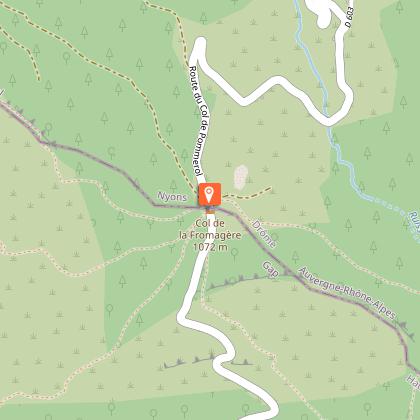
From La Sapie (1497 meters), follow the track of « la passière de la Sapie ». The panoramic view offers a wonderful north sight on Saint-Romans mountain, the village and the ruins of Pommerol. The left path is hard to see – an information board is near the path. – There are a few stairs to walk down, be careful of the roots, the slope is quite steep. Then, an easier path leads to la Fromagère pass (stay on the main route.).
At la Fromagère pass (1091 meters), take the path on your right and follow right away the left one leading to « Le Grand Béal ». At the signpost (781 meters), reach the track and turn left towards Raton to go back to the departure point.
Technical Information
Altimetric profile
Starting point
Points of interest

Additional information
Public transport
Let’s limit our travel and consider using public transportation and carpooling: zou.maregionsud.fr/
Advice
WARNING: On this route, you may encounter livestock guard dogs protecting herds from wolf attacks.To avoid any incidents, it is strongly advised not to bring a dog, even if it is on a leash.If you come across a herd, remain calm: stop, allow the guard dogs to get a good look at you, then give the herd a wide berth without making any sudden movements.To learn the proper precautions to take when encountering guard dogs, visit: rando.sisteron-alpesprovencales.fr/information/14-les-patous-et-nous-! Good shoes and warm clothes are essential. Some areas are exposed to wind. Caution : the path of La Passière de la Sapie is steep. You can start from the Col de Pommerol.
Advised parking
Parking "Hameau de Raton"
Access
From Nyons (at 41 Km), drive towards Gap on the departemental road D 94. Then take the departemental road D 25 in the direction of « Col de la Fromagère. » After more or less 3 Km, take a smaller road heading to the Raton’s hamlet. The road quickly turns into a track and ends up at the hamlet. Parking : Parking lot, « Hameau de Raton ».
Arrival
Raton's hamlet, Rosans (or from Col de Pommerol)
Departure
Raton's hamlet, Rosans (or from Col de Pommerol)
Data author
