Alert
Alerts
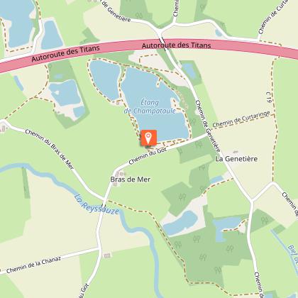
Stroll - Champataule lakes & Poype de Marillat land


IGN cards


Description
From the Champataule lakes (south and north), head off to the lands of the Lords of Marillat, around their poype. Between Reyssouze, Jugnon and ford des Merciers, Viriat's countryside opens up gently.
What to see: Le Jugnon / la Reyssouze / Champataule Sud-Nord / Plan d'eau des Vernay / Calvaire des Merciers / Moulin Peloux.
Technical Information
Altimetric profile
Starting point
Additional information
Environments
In the country
Lakeside or by stretch of water
Riverside
Lake 5 km away
River 5 km away
Village 2 km away
Waterside
Pond within 5 km
Cycling itinerary less than 1 km away
Updated by
Bourg-en-Bresse Destinations - Office de tourisme - 24/11/2025
www.bourgenbressedestinations.fr
Report a problem
Open period
All year round daily.
Contact
Phone : 04 74 22 49 40
Email : accueil@bourgenbressedestinations.fr
Website : https://www.bourgenbressedestinations.fr
Facebook : https://www.facebook.com/BourgenBresseTourisme
Type of land
Ground
Hard coating (tar, cement, flooring)
