Alert
Alerts
Hiking: Echenevex - Branveau - Montchanais


Description
A demanding but accessible hike in the heart of the Haute Chaîne du Jura for lovers of wide open spaces.
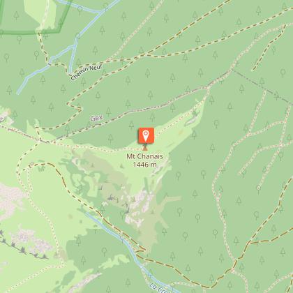
From the village of Echenevex, the path leads through meadows and woods, before beginning the ascent to the Col de Branveau. Here you can often spot chamois and cows grazing on alpine pastures, who on fine days enjoy a breathtaking panorama of the Jura ridges. The climb continues to the summit of Mont Chanais at 1446m where a 360° view rewards walkers' efforts. From here, you can contemplate Mont-Blanc, the Alps and the valley below, before returning down to the heart of the Haute Chaîne du Jura.
The route takes in the heart of the Haut-Jura Regional Nature Park, and part of the Haute Chaîne du Jura National Nature Reserve: a protected, unspoilt area to be explored with respect.
Good to know - Protected area
Part of the route passes through the Haute Chaîne du Jura National Nature Reserve, which is subject to special regulations:
Dogs are not allowed, even on a lead.
Camping in tents prohibited.
Please respect these rules to preserve the richness of this exceptional environment.
Technical Information
Altimetric profile
Starting point
Points of interest
Date and time
- From 01/04/2026 to 30/11/2036
- From 01/04/2027 to 30/11/2037
Additional information
Contact
Phone : 04 50 28 09 16
Website : https://www.paysdegex-montsjura.com
Open period
From 01/04 to 30/11 daily.
Subject to there being no snow.
Subject to favorable snow and weather conditions.
Environments
In a nature reserve
Mountain view
Panoramic view
Lake view
Mountain location
Type of land
Rock
Stone
Ground
Hard coating (tar, cement, flooring)
Topo guides and map references
Topo guides references :
Hiking in Pays de Gex and the Haute Chaine du Jura: on sale at Pays de Gex tourist agencies: 9€.
Map references :
3328OT - CRÊT DE LA NEIGE
Updated by
Office de Tourisme du Pays de Gex - 09/07/2026
www.paysdegex-montsjura.com
Report a problem
Reception complements
▶ This route crosses the Haute Chaîne du Jura National Nature Reserve. Please respect the regulations.
The rules include the following:
Dogs are strictly forbidden, even on a lead.
Plant picking and mineral collecting are also prohibited.
▶ Before setting off :
Check the general and local weather forecast, and make sure there's no precipitation.
Find out about the approach route, the height of the itinerary, the time it will take to complete the climb, and any possible escapes (IGN map, GPS, topo-guide, etc.).
Evaluate possible risks by asking mountain professionals, mountain huts and gîtes.
Inform someone close to you of your objective, and contact them again in the event of any changes: departure and return times, number of participants with telephone numbers for each, vehicle(s), parking, etc.
Avoid setting off alone, and use equipment that is suitable for the activity, adjusted and in good condition: headlamp, complete first-aid kit, survival blanket, etc.
In the event of a problem, call 112 (European emergency number).
Guidebook with maps/step-by-step
(1) From Place de la Mairie, follow the yellow signs. With the Haute Chaîne du Jura in front of you, turn right onto the rue François Estier, then first left onto the rue du Stade. Continue up this street onto the Rue de la Pierre, then take the Chemin du Pied du Mont. At the top of the village you will see a fountain and an information panel.
(2) Turn right onto the white path and start climbing towards La Carrière. The path gradually climbs above a housing estate on the chemin du Réservoir. Turn left twice to bypass the reservoir. The white path becomes a footpath, continue straight ahead and enter the forest.
(3) At the intersection, turn left. The path widens out again, follow it for 400m with two hairpin bends, then find a trail. It contours the mountain in an undulating fashion before forking right for a short but steady climb. Cross the forest road, turn left and then immediately right onto a white track. You will reach the next intersection after just over 1km.
(4) At Jet de la Reine (altitude 1090 m) turn left still on the white track. This runs along the contour line for several hundred metres, then forks right to climb gradually to the Branveau mountain pasture.
(5) At the chalet, go around it and keep to the right to get to the other side. The path overlooks the chalet, continue on this path to the pass.
(6) At the Col de Branveau, enjoy the panoramic view of the surrounding rock circus and the ridges of the Monts Jura. The path leading to the highest point of the hike continues along the ridge line to the right. Continue for around 500m to reach Montchanais (1,446 m altitude).
Return by the same route.
Animals
No. Dogs strictly forbidden
Data author
