Alert
Alerts
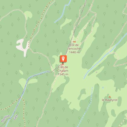
Hiking trail - Crêt de Chalam from Forens
1 alert on this circuit
Visitor alert
Faulty beaconing, safety incidents, conflicts of use, illegal dumping? Locate and share the problem you have encountered on the national alert system via the SURICATE app or the sentinelles.sportsdenature.fr/ website.
Description
This peak is a must-see for its unique views of the Valserine valley, the Jura and Mont-Blanc. After a climb through the forest, a flight of steps will complete the hike for a contemplative reward!
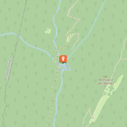
This hike, which can be enjoyed from April to November, starts from Forens. A path leads through the woods to the ruins of a house called the “Grand Mannet”. The view gradually opens up over the Valserine valley and the Haute Chaîne du Jura. The last few metres are up a steep path, followed by steps to the summit. From here, a 360° panorama of the Mont-Blanc which appears so close to the Jura mountains and the folds of the Jura massif. then to, note the “Borne au Lion”, the 17th-century border marker between Franche-Comté, Bugey and the territory of the Duchy of Savoy. Explanatory panels tell the story of the resistants who hid here during the Second World War. To round off the hike, a short detour to the lovely Étrès waterfall is a must.
Technical Information
Altimetric profile
Starting point
Points of interest
Date and time
- From 01/04/2026 to 30/11/2036
- From 01/04/2027 to 30/11/2037
Additional information
Contact
Phone : 04 50 28 09 16
Email : contact@paysdegex-tourisme.com
Website : https://www.paysdegex-montsjura.com
Open period
From 01/04 to 30/11 daily.
Subject to there being no snow.
Subject to favorable snow and weather conditions.
Environments
Riverside
Overview on river
Mountain view
Panoramic view
Waterside
Close to a public transportation
Waterfall view
Type of land
Stone
Ground
Hard coating (tar, cement, flooring)
Grit
Not suitable for strollers
Topo guides and map references
Topo guides references :
Hiking in Pays de Gex and the Haute Chaine du Jura: on sale at Pays de Gex tourist agencies: 9€.
Map references :
3328OT - CRÊT DE LA NEIGE
Updated by
Office de Tourisme du Pays de Gex - 16/04/2026
www.paysdegex-montsjura.com
Report a problem
Reception complements
▶ Before setting off :
Check the general and local weather forecast, and make sure there's no precipitation.
Find out about the approach route, the height of the itinerary, the time it will take to complete the climb, and any possible escapes (IGN map, GPS, topo-guide, etc.).
Evaluate possible risks by asking mountain professionals, mountain huts and gîtes.
Inform someone close to you of your objective, and contact them again in the event of any changes: departure and return times, number of participants with telephone numbers for each, vehicle(s), parking, etc.
Avoid setting off alone, and use equipment that is suitable for the activity, adjusted and in good condition: headlamp, complete first-aid kit, survival blanket, etc.
In the event of a problem, call 112 (European emergency number).
Guidebook with maps/step-by-step
(1) Start at the Forens washhouse on the RD 14. From the very first steps, the path rises gently winding under the canopy of trees skirting a peaceful stream. Gradually, the slope becomes steeper inviting you to start climbing.
(2) From this house the white path gives way to a narrower path that gently winds into the forest between the trees.
(3) The route passes an old spring and a ruin still clearly visible, vestiges of another era. It then climbs along a shady ridge, where the light filters through the foliage.
(4) After several hundred meters of ascent through the forest, the vegetation gradually opens up, revealing a small valley with a panoramic view of the surrounding area. Continue straight ahead at the intersection.
Animals
Yes. Accepted but on a leash.
Data author
