Alert
Alerts
Balcon du Pré Rond - Les 3 Croix - Hiking trail


Description
The Pré Rond balcony trail allows you to explore Valloire's surroundings, its hamlets and traditional architecture, with a magnificent panoramic view.
To activate geolocation, click on the map icon.
Technical Information
Altimetric profile
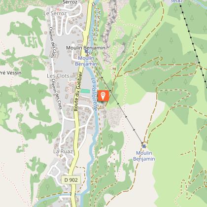
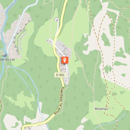
Starting point
Points of interest


Date and time
- From 15/05/2026 to 15/10/2026
Additional information
Tips
When hiking, there are a few things you can do to make your experience safer and more enjoyable. Walking poles (even on roads) improve balance in icy conditions, crampons provide grip, and regular hydration is essential.
Carry a water bottle and snacks to keep your energy up. Protect yourself from the sun with sunscreen and sunglasses. Don't forget binoculars to add a touch of observation to your adventure.
Finally, check weather conditions and avalanche risks before you set off. Inform someone of your itinerary, as communication may be limited. These small adjustments will help you make the most of your getaway.
Updated by
Office de Tourisme de Valloire - 08/12/2025
www.valloire.net/
Report a problem
Environments
Mountain view
Mountain location
Open period
From 15/05 to 15/10 daily.
Subject to favorable snow and weather conditions.
Contact
Phone : 04 79 59 03 96
Email : info@valloire.fr
Website : https://www.valloire.net/
Topo guides and map references
Map references :
Map of Valloire hiking and mountain biking trails, on sale at the tourist office.
IGN map 3435ET VALLOIRE - Aiguilles d'Arves / Col du Galibier is on sale in Valloire shops.
Type of land
Rock
Stone
Ground
Not suitable for strollers
Reception complements
To keep the mountains a pleasure, choose an activity suited to your level of experience and physical ability. Check the weather and seek advice from qualified professionals, and tell someone about your itinerary. Set off with the right equipment: good shoes and walking poles. In your rucksack, carry a water bottle and snacks to keep your energy levels up, a survival blanket or warm clothing. Protect yourself from the sun with sunscreen and sunglasses. Don't forget binoculars to add a touch of observation to your adventure.
Guidebook with maps/step-by-step
Departure point: Parking de la Borgé. 1 - Take the path on the left of the Valloirette up to the equestrian center. 2 - Go left up the trail to Chapelle Saint Pierre. 3 - Rejoin a track further up, then turn left to descend to the Gorges de la Neuvachette footbridge. 4 - Join the hamlet of Archaz, then Geneuil. 5 - Take a track that passes under the Brive gondola to Poingt Rogereuil. 6 - Continue on the track, then take a path on the left that leads to the Chapelle des Trois Croix (orientation table). 7 - [Optional] Possibility of joining the Col du Télégraphe via the forest track (view of the Maurienne and Vanoise Massif). 8 - Return to Valloire via the hamlets of Col, Granges and Choseaux-Ville.
Animals
Yes. Pets must be kept on a leash.
Data author
