Alert
Alerts
Walking tour exploring Saorge and the trades of the Salt Road
Description
Your discovery of Saorge, a striking balcony clinging to the mountain above the Roya and Bendola gorges, will be marked out by 8 steel figurines representing the trades of the Salt Road era: Saorge was one of the crossing points.
Saorge is a monument in itself, with its amphitheatre-like Tibetan village clinging to the mountain above the Roya and Bendola gorges. This trail of old trades from the days of the salt route, marked out by 8 steel figurines closely linked to Saorge's historical heritage, was created by the Communauté d'agglomération de la Riviera française (CARF) in partnership with the Mairie de Saorge, as part of the Interreg Alcotra and Alpimed Patrim project.
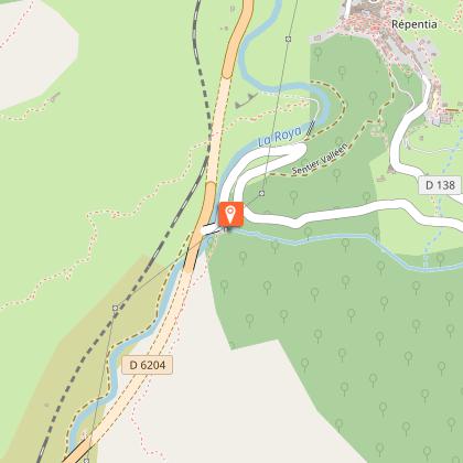
The route starts from the upper East car park, where you will be greeted by the Franciscan figure no. 8. Take the narrow path that cuts across the wide bend in the RD 138 road. On the road, head up towards the beautiful 11th-century Romanesque chapel of the Madonna del Poggio, on your left. Immediately after turning left, leave the road to go down the little path, which offers some superb views over Saorge. You will come across the stonecutter's figurine no. 7. You will reach the wider Chemin des Châtaigniers, which you will walk down for a few metres. Once you have passed the valley, take the narrow path down to the old Saorge olive grove on your right (before the calvary).
You'll discover figurines no. 3 representing the harvest and a fountain, then no. 4, the figure of the mason, an essential artisan in this terraced farming and path maintenance.
You'll then come to the Roya and its roaring torrent, where you'll discover figurine no. 5 of the muleteer.
You'll see a number of remains on this river bank, which looks more like a wadi or mountain torrent than a river: the Salt Road used to take the beautiful path to the Paspus chapel from Breil on the right bank, crossing the Roya there and then heading back up under the village of Saorge along exactly the same path you've just taken.
The remains of the Saorge water treatment plant, destroyed by storm Alex on 2 October 2020, still lie in ruins.
Just beyond, the remains of the retaining walls of the old Nice-Turin Royal Road, opened in the 17th-18th centuries, snake beneath the modern road torn up by Storm Alex.
You leave the "Pont du Commun" on your right, one of whose arches was swept away by the storm: access has since been refilled.
When you reach the RD 138, make a short round trip to the Sémite bath for a moment of serene coolness!
Retrace your steps and take the path on your right at marker 16: it cuts across the wide bend in the road made by the RD 138.
At the road, walk back down a few metres and turn right onto the Chemin des Châtaigniers, signposted 17.
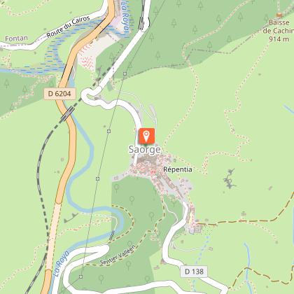
Make sure you stop at the calvary overlooking a cliff: it offers a splendid view of Saorge.
Once you reach the chemin de Meyran (concrete path) at marker 19, turn left up the hill into the village.
You will never leave Rue du Président Doumergue, or Carera Soutana in Saorgian, which crosses the impressive Place de la République or Ciassa Soutana (14th century, remains of medieval ramparts).
Pass through the "cunun" or covered passageway to take Rue Virgile Barrel or Carera Mediana, and you will find yourself at the entrance to the medieval village, Place Georges Clémenceau or "Ciapagne" in Saorgian.
Go straight ahead along the avenue du Dr Joseph Daveo, a former prominent figure in the village, cross the place Honoré Steva or "Basket" in Saorgian, and continue straight ahead to reach the old mills and the chapel of Saint-Roch on your right: Figurine no. 1
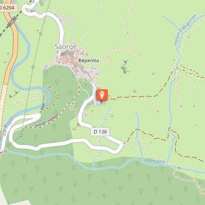
And a little further down on your left, the Calvary and then the view over the tight, breathtaking twists and turns of the old Saorge road, with the Cairos valley in front of you joining the Mercantour peaks, the cime du Diable on the right to the north, and the redoubt of the pointe des Trois Communes on the ridge to the left to the south, just over there.
Retrace your steps to visit the middle and upper parts of the village that you didn't see: the church of St-Sauveur, the chapel of the white penitents, the climb up to the Place de la Caranca, the Repentia path that takes you to the Monastery, and back via the rue Louis Périssol, the Medge wash-house with its soft, colourful tones, the chapel of the black penitents where the municipal library is located...
Don't hesitate to get lost in this maze of alleyways, "cuniuns" (covered passageways rather like Lyon's "traboules"), staircases and calades, typical of Ligurian architecture! A local will always be there to show you the way out...
Technical Information
Altimetric profile
Starting point
Points of interest
Additional information
Environments
Close to GR footpath
Mountain location
River -5 km away
Village -2 km away
Updated by
Office de Tourisme Menton, Riviera & Merveilles - 16/04/2026
www.menton-riviera-merveilles.fr/boutique/
Report a problem
Open period
All year round daily.
Contact
Phone : 04 83 93 98 34
Email : breil-tourisme@menton-riviera-merveilles.fr
Website : https://www.menton-riviera-merveilles.fr/
Facebook : https://www.facebook.com/mentonrivieramerveilles/
Type of land
Stone
Ground
Hard coating (tar, cement, flooring)
Grit
Suitable for all terrain strollers
Data author
