Alert
Alerts
Les Platières

Description
A pretty open route through high pastures from la Vie Neuve des Molunes, a sector which is characterised by its dispersed habitat.
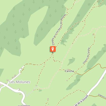
On the corner of the stopover gite AUX MOLUNES - LA VIE NEUVE, the trail starts on the path (yellow waymarking) along the hay fields towards les Granges. Staying on this path, head past a small ridge to your left and gradually descend. The path cuts through a small forest and opens onto a meadow.
Take the grassy path that is more or less marked out descending along the ridge to the right. (Note to your left a former farm with a granary). Cut through a forest and exit onto a small road. Follow this road to the left to les Granges.
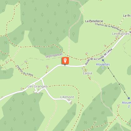
The road to your right will take you to the houses in Laisia.
A stone path ascends to the right towards les Platières. Bordered by ashes, it quickly ascends and opens out onto the combe at the summit. Cross this combe and head back down, opposite your, through the woods, to the hamlet of Les Platières.
Take the very stony path to your left into the forest (white and red waymarking). Head to an open combe and follow a trail to your left into the pasture of Les Platières (cycling path). Go past a small lodge, down into a pasture to your right (cycling path) and reach the west ridge. Follow an old, little marked, path to the left of the valley that will take you to the crossroads in Cariche.
The path (two cycling paths), descends through the meadows and heads up to a beautiful farm. Heads back downhill via a stone path to your left. You will come to a road, which you will follow to return to your starting point.
Technical Information
Altimetric profile
Starting point
Points of interest


Additional information
Public transport
To visit and get about in the High-Jura, visit www.reshaut-jura.fr, the eco-mobility portal listing all means of transport within the Park.
Advice
This trail passes through pastures with livestock and forest paths. To respect the owners and farmers granting you passage, and for the security of livestock and wild fauna, we ask that you remain on the waymarked paths. Use the adapted passageways to get across fencing and be sure to close gateways behind you. Please keep your dog on a lead if you have one. Wild flowers are beautiful, they may be rare and protected and often wilt quickly. Do not pick them! They will delight the next hikers. In case of forest works (felling, skidding, etc.), for your safety, know when to stop and turn around.
Advised parking
near the town hall
Access
25 km from Saint Claude, via the D 436 until l’Évalide, followed by the D 25 to La Cernaise, and lastly, the D 292 E1 via Les Rasses and le Petit Crêt de Let, to reach la Vie Neuve des Molunes.
Arrival
Town hall parking lot in the hamlet of La Vie Neuve
Ambiance
From one combe to another, farms and lodges are scattered across les Platières, the little roof of the Jura. From its many viewpoints, the High Jura Mountain Range and Bellecombe lazily unfold, marked by the crêt de Chalam much like an exclamation point!
Departure
Town hall parking lot in the hamlet of La Vie Neuve
