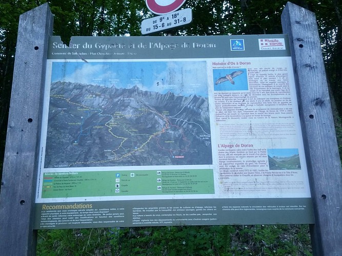
Hiking Trail: Doran via the Gypaète trail
Description
This forest path, whose slopes are a little steeper than the classic route, allows you to stay cool in the summer but especially, ensures you avoid the 4x4s.
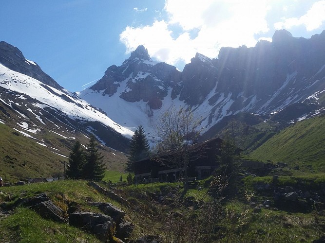
On arrival, there is a magnificent view over the Pointe Percée, the highest point (2750 m) in the Aravis range.
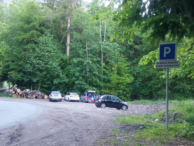
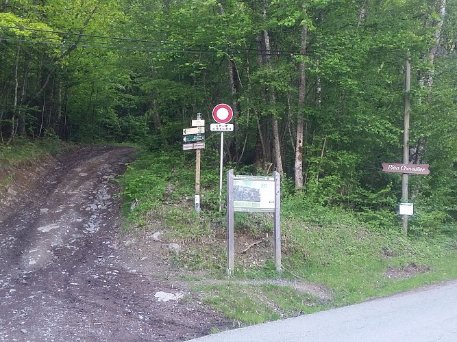
Departure: Plan Chevallier car park
1. from the car park you can either follow the road or take the Gypaète forest path which will join the road a little further on.
2. continue on the road which leads to the village of Outredière (889 m).
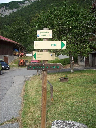
3. In the village, follow the sign indicating Doran via the Gypaète trail.
4. Just before taking the path on the left, admire the view of the Voice Stone in the distance.
5. Follow the path to the left with the small signs.
6. You will arrive at a junction, at a place called "les Pendants", where you will have to continue on the Gypaète trail (unless you want to make a detour to see this famous Pierre à Voix which is 10 min away).
7. continue along this forest path all the way up to the next sign which will tell you to take the dirt road on the left which rises through the fields, then into the forest. The climb is sustained, but also offers great opportunities for rest to admire the plunging views over the Arve valley. In the distance, dominates the Mont-Blanc massif.
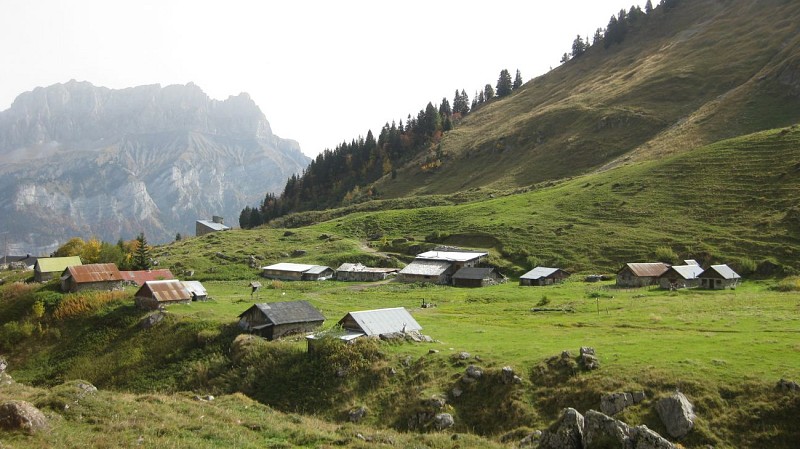
8. Approaching the Prés d'Outredière chalets, the route turns sharply 90 ° to the left at the edge of the field, and continues along a narrow path that crosses several streams and climbs in tight zig-zags through the maple trees. , to the foot of the cliff.
9. A short crossing on the mountainside will take you to cross the Torrent de Dière (water catchment).
* Please note, this bridge is dismantled in winter and the corresponding indication - open / closed - is then indicated on the markings in place at the exit of the hamlet of Outredière.
9. Shortly after the footbridge, the path continues to the right by a few wooden steps, and you then reach the valley of Doran and its chalets.
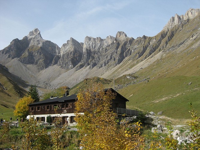
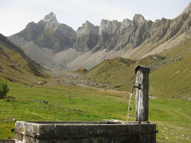
Nestled in the heart of a grandiose mountain cirque dominated by Pointe Percée, the highest point of the Aravis, the Doran pasture invites you to discover - from June to September - its ancestral agro-pastoral and cheese activity where you can buy cheese. fresh, the astonishing history of a chapel built by the scouts, the fauna and flora of the alp and in particular the astonishing Bearded Vulture, reintroduced here a few years ago. And of course the charming Doran refuge which will welcome you there for a drink, a blueberry pie or even offer you a lodging for the night.
Many hikes also start from this mountain pasture: the Saix ridge to reach Mayères, the Col de Doran for Quatre-Tête or Pointe Percée or even the towers and Pointe d'Areu ....
10. We advise you to go back down in a loop by taking the 4x4 trail
11. on the plateau before arriving, turn left to join Plan Chevalier by the forest track.
11. The round trip is less recommended because the slope is a little steep for a descent, but achievable for those who wish it.
Walking time is approximate and does not include break times.
Go on a safe hike!
This description allows you to orient yourself globally but does not replace a hiking map at 1/25000 or other topoguides that you can find in your tourist office! In Sallanches, our Office of Guides & Accompanists also offers a wide choice of outings accompanied by mountain professionals providing you with complete expertise on the environment and alpine nature, think about it!
Whatever your hike, check the weather before heading out.
Remember to take cereal bars, sufficient water, sunglasses, sunscreen, a small first-aid kit, as well as clothes suitable for your outing depending on the season in your backpack. and the forecast forecast.
Technical informations
8.3 km
|
min. 99999 m
832 m
831 m
| |||
Public : Pilgrims | ||||
Altimetric profile
Starting point
Points of interest
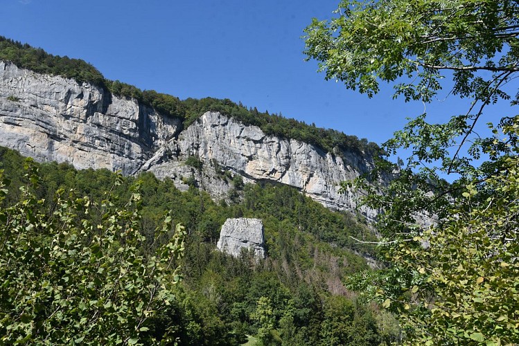
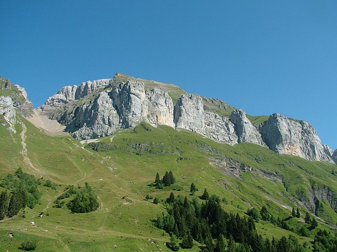
The Pierre à Voix (limestone monolith)
La Pierre à Voix is a natural limestone monolith site, which can be seen sticking out above the forest from Sallanches. Access is from the hamlet of Outredière via the famous Gypaète path, which leads to the lush Alpage de Doran (mountain pasture).
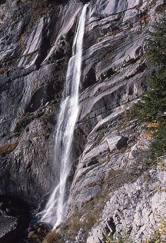
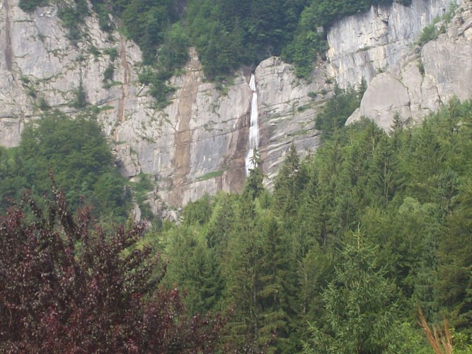
La Cascade de Doran (waterfall)
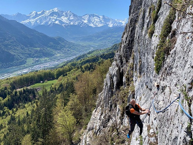
Very beautiful mountain waterfall located in Doran, visible from the hamlet of Outredière and accessible with the guides from the Bureau des Guides de Sallanches via the famous Via Corda in Doran.
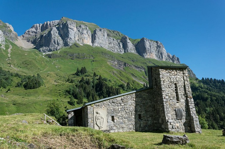
Chapelle de Doran (Chapel)
The Chapelle de Doran "Notre-Dame de la Paix du Monde" (Our Lady of World Peace) was built by the Boy Scouts between 1951 and 1965, at an altitude of 1600m, for shepherds who lived there during the summer who needed somewhere to pray.
les Chemins du Vertige
Entre randonnée et alpinisme, découvrez les "randos du vertige" ! 2 superbes journées de marche et d'escalade vous feront découvrir le versant sud des Aravis. Cette sortie est une exclusivité du Bureau des Guides de Sallanches.A mi-chemin entre la randonnée alpine et l'alpinisme, les Chemins du Vertige vous proposent 2 belles journées originales au cœur des alpages de Doran. Venez gravir soit une via corda et le plus haut sommet des Aravis : la Pointe Percée à 2752m d'altitude par les fameuses Cheminées de Sallanches, qui sont à elles seules une véritable petite course d'alpinisme qui réclame endurance et pied montagnard ; soit les 2 via corda : celle de Doran pour commencer et celle du Gypaète, sous les Quatres Têtes pour finir. Cette activité s'adresse à des personnes sportives sachant évoluer facilement sur des chemins de montagne pendant au moins 6h. Mise en jambe en prenant un peu de hauteur grâce à la via corda surplombant la vallée où vous pourrez "toucher" la fameuse cascade de Doran ! Nous rejoignons ensuite le refuge de Doran à 1500m d’altitude par un beau sentier dans les bois. L’après-midi, découverte de l’alpage en allant à la rencontre de l’alpagiste et de ses troupeaux sans oublier la fameuse chapelle des Bergers. Après une bonne nuit en refuge, nous partons en direction des Quatre Têtes où vous découvrirez une via corda plus sportive. Un panorama exceptionnel vous attend au sommet.
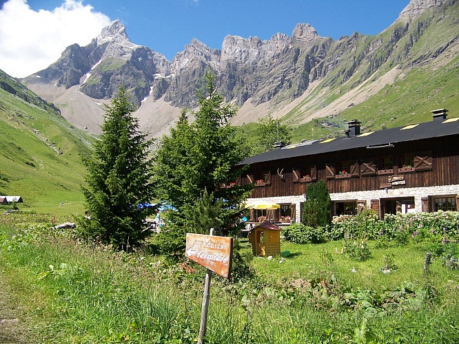
Restaurant d'altitude de Doran
Mountain restaurant nestled at the foot of La Pointe Percée where the Doran Valley has stayed true to its roots. Soak up a spot where agriculture, sport and nature thrive in perfect harmony.-trash economies -renewable energy - Hot water made with local wood - local product ( fruit and vegetable, meat, beer...)
L'Alpage du Fresnay (mountain pasture) in Doran
At the foot of the Pointe Percée peak and to the sound of the bells of the Abondances (cows), Bernard and Jean-Louis Ballet-Baz welcome you to their alpine farm in Doran at 1500 m altitude. They sell cheese on the farm and at the Sallanches market on Saturday morning.
Date and time
- From 15/05/2024 to 15/10/2024
- From 15/05/2025 to 15/10/2025
Additional information
Updated by
Office de Tourisme de Sallanches - 16/04/2024
www.sallanchesmontblanc.com
Report a problem
Open period
From 15/05 to 15/10.
Subject to favorable snow and weather conditions.
Contact
Phone : 04 50 58 04 25
Email : tourisme@sallanches.com
Website : www.sallanchesmontblanc.com
Facebook : www.facebook.com/sallanchesmontblanc
Data author
