Alert
Alerts
Walking tour : Lélex - Truchet viewpoint
Description
A ridge hike with a beautiful view of the Valserine valley and the village of Lélex, overlooked by the high Jura chain.
The trail winds gently uphill through meadows and forests. As you gain height, the view gradually opens up to the Truchet lookout, perched at 1187m above sea level. From here, the view embraces the Haute Chaîne du Jura, with glimpses of the Colomby de Gex summit and the Reculet cross. The terrain of the Jura is now visible from a different angle, with the colours changing with the seasons. The return journey takes the same route, offering a new perspective on the valley.
Technical Information
Altimetric profile
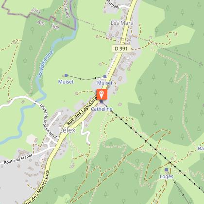
Starting point
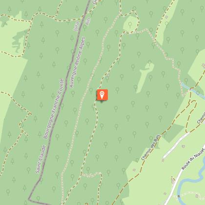
Points of interest
Date and time
- From 01/04/2026 to 30/11/2036
- From 01/04/2027 to 30/11/2037
Additional information
Open period
From 01/04 to 30/11 daily.
Subject to there being no snow.
Subject to favorable snow and weather conditions.
Updated by
Office de Tourisme du Pays de Gex - 09/07/2026
www.paysdegex-montsjura.com
Report a problem
Environments
Overview on river
Forest location
Village -2 km away
Contact
Phone : 04 50 28 09 16
Website : https://www.paysdegex-montsjura.com
Type of land
Stone
Ground
Topo guides and map references
Topo guides references :
Hiking in Pays de Gex and the Haute Chaine du Jura: on sale at Pays de Gex tourist agencies: €9.
Map references :
3328OT - CRÊT DE LA NEIGE
Reception complements
▶ Before setting off :
Check the general and local weather forecast, and make sure there's no precipitation.
Find out about the approach route, the height of the itinerary, the time it will take to complete the climb, and any possible escapes (IGN map, GPS, topo-guide, etc.).
Evaluate possible risks by asking mountain professionals, mountain huts and gîtes.
Inform someone close to you of your objective, and contact them again in the event of any changes: departure and return times, number of participants with telephone numbers for each, vehicle(s), parking, etc.
Avoid setting off alone, and use equipment that is suitable for the activity, adjusted and in good condition: headlamp, complete first-aid kit, survival blanket, etc.
In the event of a problem, call 112 (European emergency number).
Tricky passages
There are ruts caused by the use of forestry machinery, and the ground can be slippery.
Guidebook with maps/step-by-step
(1) From the Lélex Tourist Office, follow the yellow signs to the left. Walk along the Grand Crêt building, past the ESF chalet, then join the two-way road. Continue for about 10 m, skirting a house.
(2) At this point, follow the GR (red and white) to the right, and descend along the Route du Frenet. Pass the Chapelon farm, the Louis Marchand chalet, the tennis courts, then cross the Fruitière bridge.
(3) Leave the GR just after the bridge, and continue straight ahead. The route becomes an uphill path. About 100m further on, take the hairpin bend on the right, continue uphill, then cross a second hairpin bend. Keep left to follow the track. The path runs alongside a house, then continues for around 500m to the next intersection.
(4) At Au Petit Bal there is just over a kilometer to go to the summit. Take the rising path on the right which gradually becomes steeper. The path slaloms between trees, skirts low walls and crosses a wooded combe. Continue until you see the sign for the Truchet lookout, a few metres further on.
(5) At the highest point, the view is breathtaking over the Valserine valley, the Monts Jura and the village of Lélex in the valley below. Enjoy the panorama before returning by the same
route.
Animals
Yes. But kept on a leash
Data author
