Alert
Alerts
Rousset pass - But de l'Aiglette
Description
Crest Route with breathtaking scenery
From the tunnel carpark (1254m), take the old Roman road which overlooks the Diois, pass under the departure of the Via Ferrata, path in cornice carved in the rock. Then, go under a canopy to quickly reach a snowy valley. Shoot full North for Col de Chironne 1 (1416m). Climb south-west the slight slope leaving on the right the cross-country ski run that runs to Vassieux-en-Vercors. At point 1467m on the IGN map, join the southern edge of the plateau above the Rochers de Chironne. Follow the ridge that runs into the forest (south-west orientation). After about 1h30, reach the But de Aiglette 2 (1524m).Return:The return is identical to the itinerary of the outward journey.
Technical Information
Altimetric profile
Starting point
Additional information
Public transport
There is no regular public transport to reach Font d'Urle but from 26th of decembre to 9th of march, Drôme ski resorts organise a snow shuttle from Valence or Die to Bourg de Péage, Saint Laurent en Royans and Font d’Urle :– every saturday and sunday (26th of decembre to 9th of march)– Tuesdays and thursdays during school holiday (A zone)Booking mandatory before 5pm for the next day on billetterie-fontdurle.intence.tech/shop?category_list=259out of the ski resort season, go to Vassieux-en-Vercors via bus line 05 (Vassieux - Valence) and reach Font d'Urle hitchhiking or by carpooling.By hitch hiking : You can get there / get back by hitching a lift with the Rezo Pouce network from Autrans-Méaudre, Lans-en-Vercors, Grenoble and Royans-Vercors (you can find all the stops in the Vercors on www.rezopouce.fr).carpooling :Offer your services or book your carpooling on the regional Mov'Ici platform.
Advice
This itinerary is only to be undertaken on a safe basis. The route follows a ridge course with significant peaks. Before leaving, inquire about the level of snow, risk of cornices in edge of cliffs. The departure of the hike may lack snow.More information on Nordic WalkingNordic walking is a respectful and responsible practice. Before you jump into the field, train yourself.
Advised parking
Parking on the right after leaving the tunnel
Access
From Grenoble, take the road to Sassenage, then the D531 towards Villard de Lans. Continue on the D531 towards Corrençon en Vercors. Continue towards the Gorges de la Bourne. Follow the D103 for St Martin en Vercors, then Tourtre. At Saint Agnan en Vercors continue on the D 518 until the station of the Col du Rousset. Continue towards Die on the D518 via the tunnel. Park, right, just out.From Die, take the D 518, pass the village of Chamaloc and continue towards the Col du Rousset. Park on the left before the tunnel.
Arrival
Tunnel of the Col de Rousset
Ambiance
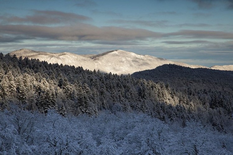
The But de l'Aiglette, from the Col de Rousset, is a more than seductive stage. Although short, this route offers a great diversity of landscapes. The ski hiker will appreciate, from the southern edge of the plateau of the Vercors, the view overlooking the marshy hills of the Diois which extend at its feet.He will have, during this incursion, perhaps the chance to observe the Vulture Fauve reintroduced in 1996 in the Regional Natural Park of Vercors.
Departure
Tunnel of the Col de Rousset
