Alert
Alerts
Hiking: Mont Joly from Le Baptieu
Description
A magnificent hike that takes you to the summit of Mont Joly, with an orientation table at the end to admire the surrounding peaks.
The Mont Joly hike is a round trip starting from the Baptieu parking lot.
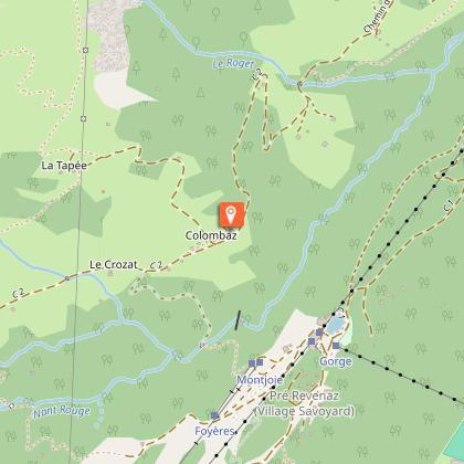
You'll first pass through the hamlet of Le Baptieu, then La Colombaz, where you'll find an Auberge and restaurant. Take the opportunity to grab a bite to eat on the way down.
You will then begin the climb to reach the Tête de la Combaz at 2045m altitude. The rest of the hike is fairly gentle, as you follow the ridge to finally reach your goal, Mont Joly at 2525m.
From the summit, you'll have a 360° view, not only of Mont Blanc, but also of the villages of Megève and Les Contamines.
Technical Information
Altimetric profile
Starting point
Points of interest

Date and time
- From 01/05/2026 to 30/09/2026
- From 01/05/2027 to 30/09/2027
Additional information
Open period
From 01/05 to 30/09.
Subject to favorable snow and weather conditions.
Updated by
Conseil Départemental de la Haute-Savoie - 23/02/2026
www.hautesavoiexperience.fr
Report a problem
Environments
Mountain view
Mountain location
Contact
Phone : 04 50 47 01 58
Email : info@lescontamines.com
Website : https://www.lescontamines.com
Facebook : https://www.facebook.com/LesContaminesMontjoie
Type of land
Not suitable for strollers
Location complements
Access (by car): From Les Contamines-Montjoie, take the Notre Dame de la Gorge road (D902). Turn right onto the Chemin des Echenaz and continue along the Chemin du Baptieux until you reach the Baptieux parking lot.
Topo guides and map references
Map references :
TOP 25 IGN 3531 ET - SAINT-GERVAIS-LES-BAINS / MASSIF DU MONT-BLANC
Reception complements
Whatever your hike, remember to pack cereal bars, plenty of water, sunglasses, sunscreen, a small first-aid kit, and clothing appropriate to the season and weather forecast.
Guidebook with maps/step-by-step
1/ From the Baptieu parking lot, cross the hamlet (Le Baptieu) and start climbing towards Colombaz on the footpath through the forest, or on the dirt road. After a 1-hour walk, you'll reach the Colombaz inn and chalets.
2/ To climb Mont Joly, leave the road after the Auberge de Colombaz (junction no. 121) and take the path up this steep slope to the Tête de la Combaz (junction no. 119). Then fork right and follow the somewhat airy ridge up to Mont Joly, at 2525 m altitude.
3/ Once you've reached Mont Joly, take the same route back down.
Animals
Yes. Dogs must be kept on a leash due to the presence of herds and patous.
Data author
