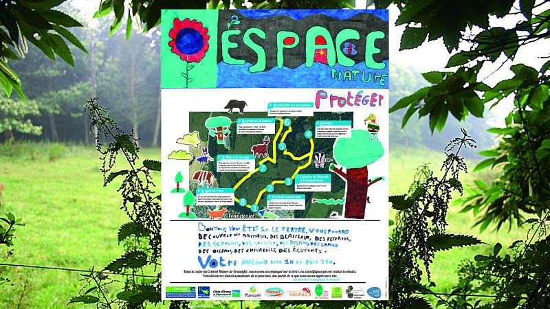
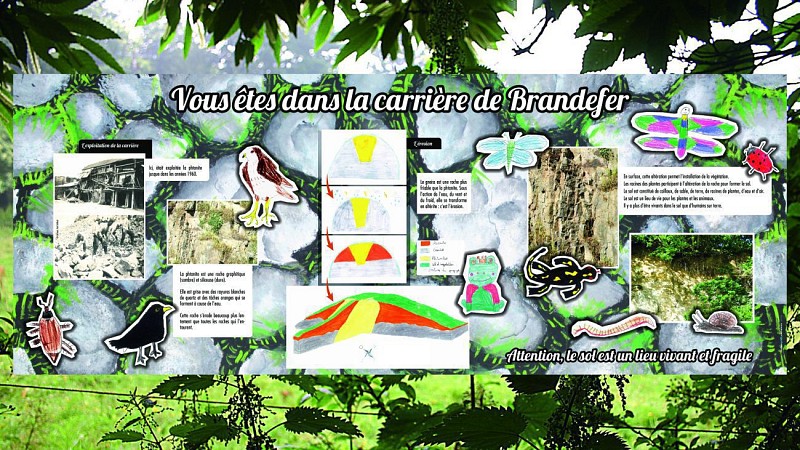
This educational path and its signs that you are about to discover were pade by Plancoët's Public School, through a Nature Régional Territorial contract "For the valorisation of the biodiversity and of the natural heritage of Plancoët." This Nature contract, that took place between 2011 and 2014, had as principal objectives to :
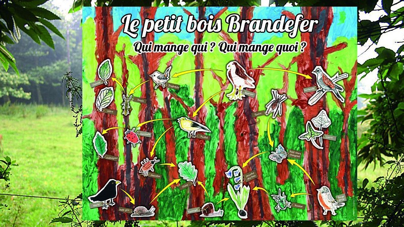
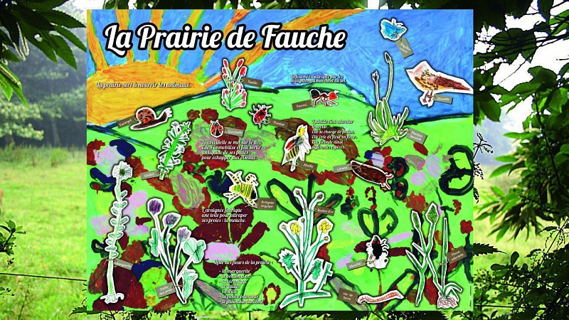
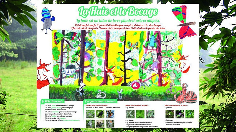
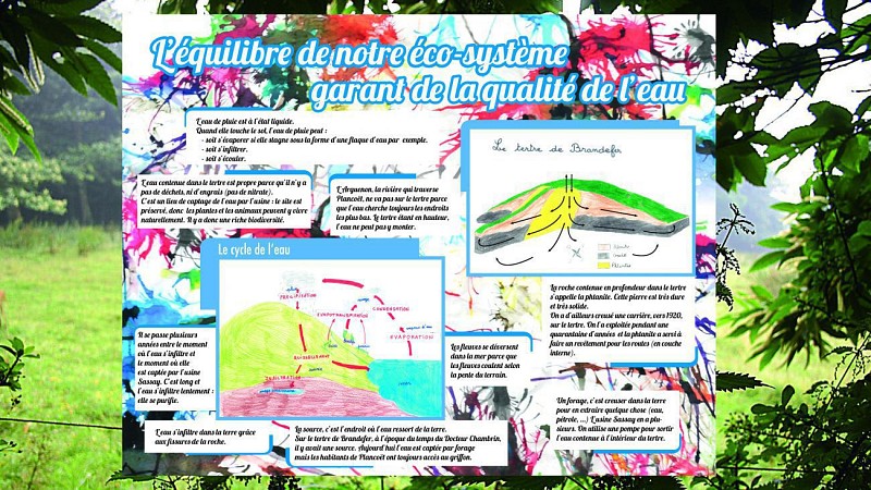
- Getting to know and promote the regional biodiversity's quality and its relations with the geo-diversity through flora and fauna invetories (vertebrate and invertebrate) and through geological studies in order to categorise habitats and their evolution, their relations with the underground, the ground's nature and of the hydrogeology of the site...
- Offer management solution for the site by concertation amongst the owners for its quality to be kept and its heritage to be valorised through a work of appropriation by the great public and educational initiative while taking into account local economical activities.
bio-scene.org/content/tertre-de-brandefer
(The suggested circuits are given as an indication and do not take into account the possible terrain or environment evolution. The users’ personal responsibility is engaged by the use of these circuits, the Office de tourisme disengages itself from any responsibility regarding the use of the maps and possible accidents that may occur on the proposed itinerary.)
2.3 km
|
max. 80 m
min. 21 m
111 m
| |||
Accessibility | ||||
Styles : HikingDiscoveryForest Public : FamilyOccasional hikersTeenagersSchool Theme : Cultural |
The first board, located at the foot of the hillock, right next to Sassay water plant, gives details on the itinerary you are going to make and locates all the different boards you'll get to come across. The site you are about to discover, preserved for over two decades, was qualified as "ordinary biodiversity exceptional island" by scientists. Therefore, we ask you to be careful during your walk and to respect the indications, the quietness of the place and above all, the nature surrounding you. For more details: www.bio-scene.org/panoramique/tertre-de-brandefer/
This board takes you through the history of Sassay Spring since its use, in 1916, by Doctor Chambrin in complementary military campaign hospitals. In 1920, we came to take the waters in Plancoët and to drink the water of Nazareth. It's only on August 2nd 1928 that Sassay's water is categorised as "natural mineral water" by ministerial decree. To this day it is the only one in Brittany to have this acknowledgement. Right from 1928, in order to protect the spring from pollutions linked to agriculture and to ensure its continuation, a building, nicknamed the "Griffon" was built. Around it, and since then, a protection perimetre of 96 ha was instaured on Brandefer hillock on which every agricultural activity is prohibited.
This board, by a large panorama, retraces Plancoët's history from Gallo-Roman times, and the Middle Ages with its walls and its castle. François Renée de Chateaubriand, born in Saint-Malo, 25km away from Plancoët, often cam to visit his grand-mother: Madame de Bédée, "at the good air of Plancoët", where he frequented Clos Bourget, went on long walks by Brandefer Hillock and Nazareth, hamlet from Corseul, linked to Plancoët in 1841. Plancoeët's economical development was linked to its port activity, the sea, that can be seen from the site, being only 4km axay, with the exploitation of marl, then dairies developed following alcohol distilleries, of which the old chimney can be made out, Sassay water plant coming in addition and to complete these activities.
The path that leads to this quarry reach the centre of the hillock through the moor and groves. After having used a steep path, remnants of the quarry's exploitation path, nowadays the kingdom of enormous ferns, we suddenly come accross some water at the bottom of a phtanite (jasp) cathedral. This siliceous rock emerges at the top of the hillock, at about 80m. It is one of the rare place of Brittany where it can be observed at the surface thanks to the surrounding gneiss' erosion. Very hard, it was exploited up to the 60's to road-bed the paths. The lake therefore formed by the meteoritic water, and as such according to seasons, becomes nowadays a favourable sport for observing Odonates, from the collared grass-snake to the aquatic insects. 14 species of odonates are identified there, 38% of the species commonly admited in Côtes d'Armor.
This board presents part of the alimentary relationships that mean life in an ecosystem, here, in this wooded area as the ones on top of the hillock. At the ground stratum level, the decomposers (snails, slugs) transform the fallen leaves to humus and will be the prey of spiders and birds such as the blackbird or the song thrush. The phytophagous insects (plant eaters) of the grassy stratum will serve as food to wood birds such as the chiffchaff or the robin which, in turn will be the preys of predator like the sparrow hawk. Sur le tertre, 48 espèces d'oiseaux ont été observées dont 44 espèces nicheuses (valeur voisine de ce que l'on observe dans un bocage typique. Les groupements forestiers représentent un peu plus de 20% de la surface du tertre (aulnaie-frênaie, ripisylve, chênaie-châtaigneraie, chênaie acidiphile).
The mowing meadows reprensent over 50% of the site's surface. The caracteristic mesophile meadows, becoming rare nowadays since they are turned over to crops (maize notably) in Western France; and the meadows said humid, often close to water streams and sometimes floodable are separated. Theses milieux host a whole flora (houlque, buttercup, daisies, clover) and a specifique fauna of invertebrates such as butterflies, bugs, grasshoppers, locusts, pollinators (bees, bumblebees) and their predators (birds and spiders). On the hillock 14 species of grasshoppers and locusts, 80 species of bugs, 33 species of butterflies, 130 species of moths or 145 species of spidres were counted.
The hedges linear and density (37 hedges) remain superior to the rest of the surrounding village, 45% of theses hedges still show densely implanted trees on top of important earth bank. On this board are detailled the roles of the hedges, typically from the Breton bovage as well as the organisation of the hedges and its fauna components. On the hillock, roe deers, foxes and badgers share food and shelter by these earth banks. From the ground stratum to the grass stratum, shrubs and trees run accross each other, avoid one another, run away or hunt a plethora of insects like the ground beetles (over 80 species of these predators were identified on the whole of the hillock), chrysomelids (over 47 species), ladybugs (18 species), weevils (118 species, nearly 51% of the total of the known species in Brittany).
This larst board reminds one of the great principals of the water cycle. It therefore shows how the rainfalls infiltrate the hillock, go through the geological layers, and constitute in the multiple cracks of the underground the water pumped from differents parts of the hillock. Sassay's water's cycle ends there, where the spring appears and by where the path started. The soil which is partly from the alteration/transformation of the rocks into water, will favourise the installation of the vegetation which in turn bring on various milieux, mediums of a remarkable biodiversity and mirror to an ecosystemical balance. The fact that these parametres are found on Brandefer Hillock indicates that it is a remarkable island of ordinary biodiversity.
There are no marks on this itinerary