Alert
Alerts
Lac de Lessy by Paradis
3 alerts on this circuit
Visitor alert
Swimming is forbidden in the lake of Lessy.
FISHING LAKE OF LESSY:
Visitor alert
Swimming, campfires and open-air fires during the day and at night, and the use of stoves and barbecues are prohibited.
Camping is prohibited on the site. Only tented bivouacs in a designated area are permitted, and only when the Refuge de Lessy is open.
LESSY LAKE:
Visitor alert
Swimming, campfires and open-air fires during the day and at night, and the use of stoves and barbecues are prohibited.
Camping is prohibited on the site. Only tented bivouacs in a designated area are permitted, and only when the Refuge de Lessy is open.
Description
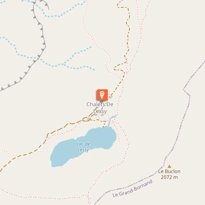
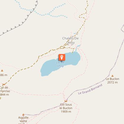
The Lac de Lessy, around which marmots and ibex make their home, is a stunning site at an altitude of 1733 m in the village of Le Petit-Bornand Glières-Val-de-Borne. It is one of the most beautiful walks in the Bornes-Aravis area.
Departure: Pteret car park, Montagne de Paradis
Difficulty: average
Period: from May to October
Views: Panoramic views from Pteret over the Arve valley and the Geneva basin.
View of the Col de la Forclaz and the Col de la Buffaz
Access: From the Mairie of Le Petit-Bornand, take the Puze road towards Paradis, then follow signs to Paradis.
Park your car at the Pteret car park (ledge next to the chalets).
Description:
At the car park, take the path in the direction of "Lac de Lessy" and follow the track through the forest. Just in front of the Chalet du Lainvouet (last chalet), turn left in the direction of Lac de Lessy, then walk over the area of rocks. The path continues until it reaches a little valley of fallen rocks. The path crosses this and takes you to a section that is a little more difficult, from where you can use the ladder to reach the crest that overlooks the Mayse valley.
Continue straight on along the mountainside towards the Col de la Forclaz from where you can spot the Lac de Lessy.
Walk down to the chalets and the Lessy refuge.
You can walk round the Lac de Lessy.
Your return is by the same path.
Herding dogs are present in the vicinity of the lake from the beginning of July to the end of September, they must be approached with great caution and certain instructions must be respected (see video link for explanation). Dogs must be kept on a lead.
You can download the route map for this hike!
Technical Information
Altimetric profile
Starting point
Points of interest

Date and time
- From 15/05/2026 to 20/10/2026
- From 15/05/2027 to 20/10/2027
Additional information
Environments
Lakeside or by stretch of water
Mountain view
Waterside
Lake view
Mountain location
Presence of livestock and guard dogs
Updated by
Office de Tourisme Faucigny Glières - 21/04/2026
www.tourisme-faucigny-glieres.fr
Report a problem
Contact
Phone : 04 50 97 38 37
Email : info@tourisme-faucigny-glieres.fr
Website : https://www.tourisme-faucigny-glieres.fr
Facebook : https://www.facebook.com/Faucigny-Gli%C3%A8res-Tourisme-871706486283390/?fref=ts
Topo guides and map references
Topo guides references :
Hiking guide published by Faucigny Glières tourist office
Map references :
IGN : 3430 ET
Reception complements
Swimming at Lake Lessy is strictly forbidden! An altitude lake has a very fragile ecosystem that should not be disturbed.
Tricky passages
Stones to avoid in wet weather, risk of falling stones, be careful
Guidebook with maps/step-by-step
1/ From "Paradis (Parking)" follow the direction of "Lac de Lessy (Refuge)" on the path at the end of the parking. 2/ At the intersections " Lachat ", " Lainvouet ", " Rocher de Salin " and " Lainvouet Lainvouet", "Rocher de Salin" then "Col de la Forclaz", always follow the direction of "Lac de Lessy (Refuge)". 3/ When you arrive at " Lac de Lessy (Refuge) ", go back to the starting point by the same itinerary as the first one.
Animals
Yes
Data author
