Alert
Alerts
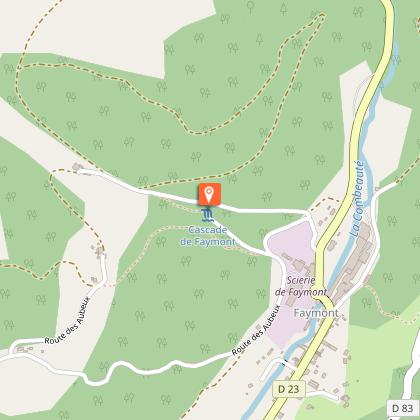
Randonnée - la cascade de faymont


Description
Access: From Remiremont, take the direction of Val-d'Ajol. In Faymont, before the sawmill, turn right.
Parking: 100m from the signpost "Cascade de Faymont".
Distance: 9km / Duration: 3 h / Difference in height: 240 m / Marking: Blue circle
1) Start on foot from the waterfall. To the right of the torrent, a steep but well-marked path quickly leads to a tarmac road. Follow it to the next crossroads.
2) Turn right. A forest path offers a steady climb through a coniferous wood.
3) A return journey of a few dozen metres leads to Roche Joséphine. Continue along a path to the left, which is narrower and more rugged than the previous one.
4) An imposing anthill was in the middle of the path when the circuit was created 20 years ago. It has strangely fallen into disrepair, but another one can be found 50m below. Just after an old farm, turn left and continue to the chapel.
5) At the chapel, take the left-hand path leading to a house and then continuing under the foliage of a small wood. Cross the small tarmac road and go straight on towards Prébosson. In the centre of the hamlet, take the tarmac path on the left.
6) Enter the forest again on a dirt track. The path crosses a cultivated area just before starting the descent after the Remoiriot Cross.
7) Cross a tarmac track to follow the forest track to the left. It leads downhill quickly to the small road to the waterfall. Go up if necessary to the car park.
Technical Information
Altimetric profile
Starting point
Additional information
Producteur de la donnée
Ces informations sont issues de la plateforme SITLOR - Système d’Information Touristique - Lorraine
Elles sont synchronisées dans le cadre du partenariat entre Cirkwi, l’Agence régionale du Tourisme Grand Est et les membres du comité technique de Sitlor.
Contact
Tel : 03 29 66 01 30
Email : plombieres@otrp.fr
Site web : www.tourisme-remiremont-plombieres.com/
Data author
