Alert
Alerts
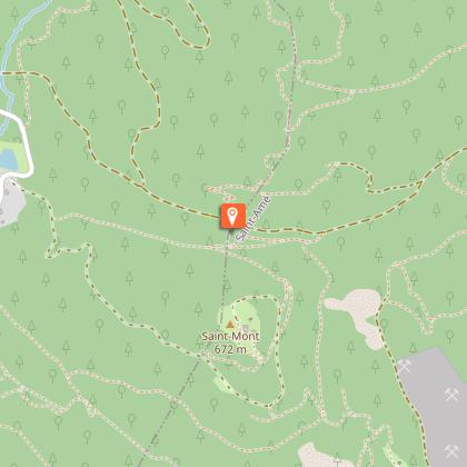
Randonnée : circuit du Saint-Mont
Description
Access: Take the direction of St Etienne les Remiremont. At the Centre roundabout, take the direction of the Gendarmerie Mobile barracks then Saint Romary(Auberge) park in the car park opposite the Auberge, on the other side of the road.
Itinerary: go up the main road. At the intersection of the two marked paths, follow straight ahead the marked path (blue ring then three markings) which will take us to the top of the Saint Mont, leaving on the left towards the archaeological excavations. From the top, go down from the plateau following again the triple beaconing towards the Pont des Fées. Cross it and take on the left the big path marked out red ring to join another marking (red triangle) to be followed towards the left while going down to join the road. Follow it on the left, always going down to join the car park.
Distance : 4,2 km
Duration: 1 hour 30 minutes
Difference in height 200 m
markings: blue ring, three markings, red ring and red triangle.
Technical Information
Altimetric profile
Starting point
Points of interest


Additional information
Producteur de la donnée
Ces informations sont issues de la plateforme SITLOR - Système d’Information Touristique - Lorraine
Elles sont synchronisées dans le cadre du partenariat entre Cirkwi, l’Agence régionale du Tourisme Grand Est et les membres du comité technique de Sitlor.
Contact
Tel : 03 29 62 23 70
Email : remiremont@otrp.fr
Site web : www.tourisme-remiremont-plombieres.com/
Data author
