To see around
See more
Open
Close
Show
Show
Show
Show
Show
Show
Show
Show
Show
Show
Show

Oups... It would appear that Cirkwi does not have permission to use your location.

Description
Map
Points of interest
Ratings and reviews
See around

RANDONNÉE - LA ROCHE TOCQUAINE

RANDONNÉE - LA ROCHE TOCQUAINE
Credit : OTRP

Description

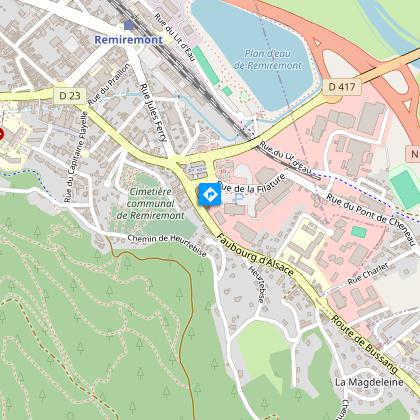
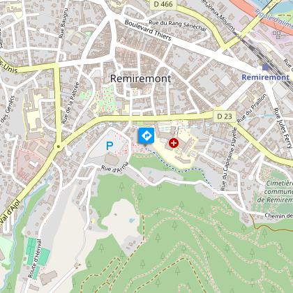
Access: From the centre of Remiremont, go past the hospital. At the traffic lights, turn right towards "Champ de Mars" and "Palais des Congrès".
Parking: Park in the Champ de Mars car park.

Distance: 10 km / Duration: 3h15 / Difference in altitude: 400 m / Signs: blue disc and red cross.

Leave from the Champ de Mars car park in the direction of the Calvary, passing a large Club Vosgien signpost. Start the walk by following the blue disc marking. At the calvary, it is possible to make a round trip for a nice view of the town and in particular the abbey church of Saint-Pierre.
After the calvary, continue straight ahead to join the "Charles David walk" which runs alongside the hospital. At the end of the path, just before reaching the road, the markings on a tree indicate a path to the right that climbs into the forest.
At a crossroads, the path turns left at an orienteering post and then becomes a path again on the right. Follow the markings still uphill.
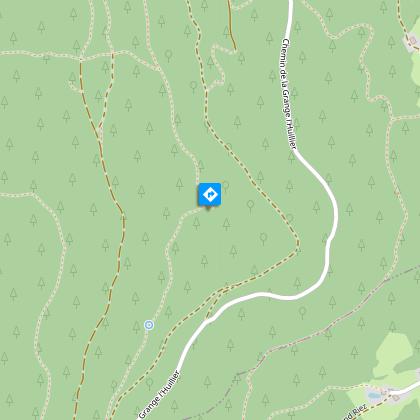
At an intersection with a carriage road, cross the road to join a path that goes to the left towards "Chalet des Gardes". Higher up, pass in front of the "roche du renard" (687 m alt). Just after the rock, continue on the path straight ahead.
At the Roche Tocquaine (660 m alt), reach the top of the rock by the path which continues straight on and then turns right uphill. To continue the walk, take the path behind the bench.
Pass in front of the "goutte du Founot" and at the end of the path, again on a track, turn right uphill.
Once you arrive at the Chalet des Gardes car park (there are picnic tables), take the "chemin de crête". Change of markings: follow the red cross. Pass the barrier, then a few metres further on leave the path for a path on the right, the "sentier des poudingues", which is easy and flat for about 2km.
At the end of the path, at the crossroads with the road, turn left downhill. Then, just before the road, turn right onto the marked path. Continue until you reach a large crossroads at the Remiremont botanical trail (caution: lack of signage). At this crossroads, go straight on the path then cross the road to join another path opposite which runs along the road to the right.
Further on, at the crow's feet, at the level of an orienteering marker n° 40, take the path which goes down to the left.
On this path, after passing a property on the left, at a crossroads, continue straight down. The path becomes a footpath and arrives on the road which leads back to the Calvary and the Champ de Mars on the right.

Technical informations

This circuit was updated on: 27/12/2023
10 km
3 h 15 mn
max. 702 m
min. 406 m
400 m

Altimetric profile

Starting point

3 Champ de Mars , 88200 REMIREMONT
Lat : 48.013202389281Lng : 6.5898571412781

Points of interest

image du object

HOTEL IBIS BUDGET

Hotel with 56 rooms, classified 2 stars, 400 meters above sea level located in the Eco-Quartier in Remiremont, 25 km from the Gérardmer and Bresse ski areas, near the TGV station, the Plan d'eau and shops. This recent hotel has 56 rooms all equipped with LCD screen TV, shower room, WC and free access to Wifi (fiber). Some rooms are accessible for people with reduced mobility. Breakfast with all-you-can-eat buffet. Free private car park. Accepted animals. Arrival from 12:00 p.m., exit until 12:00 p.m. Personalized welcome or access through the automatic room distributor using a bank card. The reception is open every day, from 6.30 a.m. to 12 p.m. on weekdays; from 7:30 a.m. to 12 p.m. on Saturdays, Sundays and public holidays. Breakfast from 6:30 a.m. to 9:30 a.m. on weekdays and from 7:30 a.m. to 10:30 a.m. on Saturdays, Sundays and public holidays.

35 Faubourg d'Alsace 88200 REMIREMONT
- Office de Tourisme Remiremont Plombières -
Consulter
image du object

PANORAMA DEPUIS LA ROCHE DES BRUYÈRES

The rock Bruyeres offers a small exploration of the forest of Remiremont, accessible and varied in its landscapes. Hiking rock Bruyeres quietly ends with the driveway Charles-David, named after a benefactor of the city that lived between 1780 and 1868. It houses his left one of the many fountains in the city. Called Fountain of Toads, this discreet basin, roughly paved, dates from the mid-nineteenth century. And down to the parking lot, you can admire the kiosk but also reverses the panoramic view of the city, imposing Calvary erected in 1858 by Bouchardon. Access: From the convention center, take the red cross behind the Roche d'Arma next to the Forest House: the path of rising terrain. As soon as the slope stops, turn left former fitness trail, Contour, which offers a magnificent view of the city and the water. Meet the red triangle and blue round path, take the descent. Leave the red triangle blue circle and continue to the junction with the green ring to go uphill on the right. Follow the trail that joins Roche des Bruyeres, above the cemetery, Calvary promenade, kiosk and on the right, Calvary dominates Remiremont.

- Office de Tourisme Remiremont Plombières -
Consulter
image du object

BED AND BREAKFAST - LE GRAND BIENFAISY

"Le Grand Bienfaisy" offers 5 guest rooms in a renovated 18th-century Vosges farmhouse on the edge of the woods, 2km from Remiremont town centre. Ground floor: entrance hall, heated room with shelves (for drying shoes), large 45 m2 living room with fitted kitchenette, TV lounge. 1st floor: 40 m2 mezzanine with library area, 5 bedrooms: "Rouge-Queue" with 2 beds 90x190, "Bergeronnette" with 1 bed 160x200 and 1 bed 90x190, "Coquelicot" with 1 bed 160x200, "Chardon" with 3 beds 90x190 and "Grand Tétras" comprising 2 rooms with 1 bed 160x200 and 3 beds 90x190. On site: garden furniture and barbecues, games area (with table tennis and table football), mountain bike trails, walking trails, horse-riding trails, fitness trail. Riders and their mounts are welcome on site. The Grange Puton equestrian centre is 500m away and offers boxes and lessons. Mme Kieffer offers massage sessions (Californian - Swedish - Foot reflexology), a moment of relaxation in a very peaceful setting. Outdoor sessions available weather permitting. Large private car park. Secure bike storage. Table d'hôte meals are available on reservation for 6 people or more. Translated with DeepL.com (free version)

Lieu-dit Le Grand Bienfaisy 88200 REMIREMONT
- Office de Tourisme Remiremont Plombières -
Consulter
image du object

INTER-HÔTEL ARUM THE ORIGINALS

3 * hotel (New Standards) family home located in the city center, close to the Palais des Congrès, the Recreation Area La Grange Puton, the Hospital and the church. Reception open from 7am to 12pm and from 17h to 21h. Non-smoking rooms with TV and telephone. Family Rooms. Free WIFI. Payment: CB Visa, Mastercard, American Express, CV

16 Faubourg du Val d'Ajol 88200 REMIREMONT
- Office de Tourisme Remiremont Plombières -
Consulter
image du object

CENTRE AQUATIQUE DE REMIREMONT

Both playful and sporty, it has high-performance equipment: a sports pool for swimmers, a training pool for beginners and relaxation with hydro massaging games, a fun pool with water games for children, a paddling pool for toddlers, two diving boards (1 and 3 meters), a slide of 45 meters, a relaxation area, special equipment for people with reduced mobility, the appointed external areas; of discoverable basins. Mandatory Sanitary Pass

75 faubourg du Val d'Ajol 88200 REMIREMONT
- Office de Tourisme Remiremont Plombières -
Consulter
image du object

THE CALVARY

The site offers a panoramic view of the city and is the starting point for the Charles David Drive and many signposted walks in the forest. Possibility of picnic in the kiosk located next door. The Calvary: Bouchardon's remarkable work on a granite shaft, made up of the cast iron statues of the Virgin Mary and Saint John surrounding Christ on the cross. Inaugurated in 1858. Part of the inscription, relating to a visit by Napoleon III in 1856, was erased after 1872. Access from the Champ de Mars

Champs de Mars 88200 REMIREMONT
- Office de Tourisme Remiremont Plombières -
Consulter
image du object

LA ROCHE TOCQUAINE

At an altitude of 660 m, these pink sandstone blocks overlook the valley and dominate the path below by about ten metres. Between the trees, you can see the Fossard massif, the village of Dommartin-lès-Remiremont. After a contemplative break on the bench, the walker retraces his steps for about twenty metres and takes this time the path that starts on his left. The descent is easy and we arrive under the Tocquaine rock. A true monument of nature that takes on its full scope here. Access by foot from the Chalet des Gardes

Sentier des Gardes La Roche Tocquaine 88200 REMIREMONT
- Office de Tourisme Remiremont Plombières -
Consulter
image du object

FITNESS TRAILS OF REMIREMONT

Fitness trail around Remiremont: - In Dommartin les Remiremont: from the site of the brewery / 2000m - Remiremont: the area of Grange Puton / 2000m - Saint Amé: from the stadium / 1450m - St Etienne les Remiremont field Moutière / 1600 - St Nabord: walk along the canal

Chemin des Granges Puton 88200 REMIREMONT
- Office de Tourisme Remiremont Plombières -
Consulter

Additional information

Contact

Tel : 03 29 62 23 70
Email : remiremont@otrp.fr

Producteur de la donnée

Ces informations sont issues de la plateforme SITLOR - Système d’Information Touristique - Lorraine
Elles sont synchronisées dans le cadre du partenariat entre Cirkwi, l’Agence régionale du Tourisme Grand Est et les membres du comité technique de Sitlor.

Data author

Ratings and reviews

To see around
See more
Open
Close
Show
Show
Show
Show
Show
Show
Show
Show
Show
Show
Show