Alert
Alerts
Tour of Lac des Plagnes


IGN cards


Description
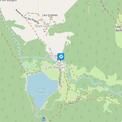
The Lac des Plagnes is the largest lake in the Abondance valley. Accessible by car, it is located 5 km from the centre of Abondance village. A short walk around the lake to refresh yourself in a mountainous setting.
The tour of Lac Plagnes is a pleasant little hike in summer. Picnic tables and benches allow you to enjoy this refreshing spot.
Lac des Plagnes is a Chablais Unesco Geopark site. From glaciers to bulging peat bogs, the trail around the lake takes you through landscapes that have evolved over the past 20,000 years.
In May and June, when the ice melts, the lake is at its highest, and the turquoise waters and snow-covered peaks make it a magnificent place to discover. At the end of the lake, you can take a variation via the Cubourré waterfall, where you'll discover some lovely cascades.
From the lake, you can see the sunny side of Mont de Grange, the highest point in the Abondance valley at 2,432 m.
This hike is accessible to all, as the tour of the lake is designed for the general public.
Technical Information
Altimetric profile
Starting point
Points of interest


Date and time
- From 01/05/2026 to 01/11/2026
Additional information
Sustainable tourism
Following the work carried out on the Lac des Plagnes and its designation as a Sensitive Natural Area, the commune of Abondance has issued a decree (municipal decree N° 179/2025) aimed at limiting practices that degrade this ecosystem and ensuring the safety and peace of mind of visitors.
Swimming in Lac des Plagnes, including for pets, and all water sports activities (except fishing) are strictly forbidden.
Dogs must be kept on a leash and their owners must pick up after them.
In a 200m zone around Lac des Plagnes, wild camping, bivouacs and campfires are prohibited day and night.
Any infringement of this by-law will be recorded in an official report.
Updated by
Office de Tourisme Leman Mountains Explore - 24/11/2025
leman-mountains-explore.com
Report a problem
Environments
Lakeside or by stretch of water
Mountain location
Waterside
Open period
From 01/05 to 01/11 daily.
Trail accessible with the arrival of good weather. In case of snowfall, avalanche passages. Access prohibited at the end of the lake in winter. Ask at the Tourist Office.
Contact
Phone : 04 50 73 02 90
Email : abondance@ot-peva.com
Type of land
Stone
Ground
Hard coating (tar, cement, flooring)
Not suitable for strollers
Location complements
Lac des Plagnes car park located less than 10 minutes by car from the centre of the village of Abondance, take direction Lac des Plagnes.
Topo guides and map references
Topo guides references :
On sale at tourist offices in the Vallée d'Abondance.
Map references :
Portes du Soleil hiking map in France and Switzerland
TOP 25 N°3528 ET Morzine Massif du Chablais Les Portes du Soleil
Guidebook with maps/step-by-step
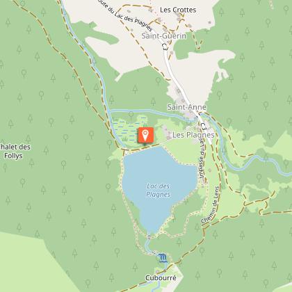
Start: Lac des Plagnes parking lot
1/ Go down to the edge of the lake and continue along the dike, following signs for "Chalets de Lens" via the "refuge des Tindérêts". Turn left at the end of the dike.
2/ Around the lake on a fairly wide path. Follow "Tour du lac" (wooden markers).
3/ At the end of the lake, after the small bridge, take the path up into the forest on your right.
4/ The tour ends with a descent to the lakeside just below the chalets. Cross several wooden footbridges to reach the dike, planted with larch and birch trees.
5/Possibility of extending the tour: 250 m ascent, 2.5 km walk.
Variant via the Cubourré waterfall: after taking the path to the right of the lake, at the end of the lake, before the wooden bridge, take the path towards the Tindérêts refuge and Cubourré. Take the forest track on the left down to the lake parking lot.
Animals
Yes. Dogs must be kept on a leash (fishing area) and wildlife.
