Alert
Alerts
Hiking at Sainte-Marguerite Lakes
Description
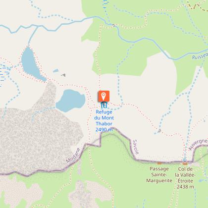
Beyond the boundaries of Valfréjus resort, immerse yourself in the enchanting beauty of an untouched mountainous landscape. Be one of the privileged few who reach the Mount Tabor refuge via the GR5 trail and treat yourself to a string of high-altitude lakes. What a complete change of scene!
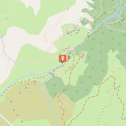
From very first twists and turns on the Lavoir trail, you start to gain height. Setting foot in Loza is like stepping into a world made purely for contemplation. Let the great outdoors work its magic. A diverse environment welcomes you, with Mount Tabor as a backdrop. The Nature Reserve, in a zone that lies between 1,750m and 3,178m above sea level, has many exciting discoveries in store. The trail takes you through the high-altitude grasses so delightful to marmots. Hidden behind the rocky formations, they keep a watchful eye on your progress and sound the alarm with their distinctive whistle. As the slope steepens, you're overcome with the thrill of exploration. A sense of infinity takes hold of you. The Mount Tabor Refuge awaits you, nestled in its lush valley. Let's go! Just a bit further, and the Rond and Long lakes will reveal their glories step by step. Recognise the Three Kings behind you, standing proudly? Balthazar, Melchior and Gaspard are lords and masters of the place.
Technical Information
Altimetric profile
Starting point
Points of interest

Date and time
- From 01/07/2026 to 15/10/2026
- From 01/07/2027 to 15/10/2027
Additional information
Open period
From 01/07 to 15/10 daily.
Subject to favorable snow and weather conditions.
Updated by
Communauté de communes Haute Maurienne Vanoise - 19/02/2026
www.cchautemaurienne.com
Report a problem
Environments
Lakeside or by stretch of water
Mountain view
Waterside
Mountain location
Presence of livestock and guard dogs
Contact
Phone : 04 79 05 99 06
Email : info@hautemaurienne.com
Website :
https://www.haute-maurienne-vanoise.com
http://www.cchautemaurienne.com/jy-vais-en
Type of land
Rock
Stone
Ground
Not suitable for strollers
Location complements
I'm going by car: park in the Lavoir parking lot (driveway from Valfréjus).
Topo guides and map references
Topo guides references :
Map and booklet "Haute Maurienne Vanoise. 120 walks and hikes - 36 trail routes. For all levels" (sold for €12 in Tourist Offices)
Map references :
Map IGN 3535OT - Névache Mont Thabor
Reception complements
The duration of hiking trails is calculated using reference paces: 300 m/h ascent, 500 m/h descent and 4 km/h on the flat.
As hazards may occur at any time on the routes, the GPX tracks provided are not contractual. They are given for information only. Riders use them at their own risk, depending on their level of technological proficiency and their understanding of the terrain.
Guidebook with maps/step-by-step
To guide you in the field, consult the "step-by-step" directional diagram provided in pdf.
Animals
Yes. Pets allowed on leash only.
Data author
