Alert

Alerts

To see around
See more
Open
Close
Show
Show
Show
Show
Show
Show
Show
Show
Show
Show
Show

Oups... It would appear that Cirkwi does not have permission to use your location.

Presentation
Description
Map
Steps
Ratings and reviews
See around

CHEMIN DE LA LIBERTÉ MARIGNAC

DSCN4215
Cartes et plans
DSCN4216
DSCN4243
DSCN4247
Cartes et plans
Credit : EB / Pyrénées31

Description

A memorial hike along the path to freedom: walk in the footsteps of refugees who fled France during the Second World War to reach Spain.

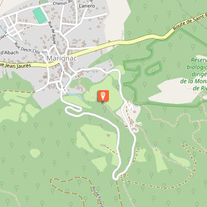
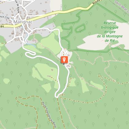
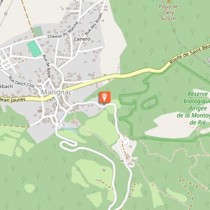
This educational trail pays tribute to the men and women who, during the Second World War, risked their lives to cross the Pyrenees and escape Nazi barbarism. This 4 km loop, marked by 12 information panels, follows in the footsteps of a group of resistance fighters who, one night in October 1943, guided by smugglers, set out to reach Spain via Bausen and the Burat Pass.
This route has been awarded the Tourisme & Handicap label for all four types of disability (hearing, mental, motor and visual).
The route is accessible on foot, by wheelchair or by car: 1.8 km long, including 1.2 km of tarmac road and 600 m of track suitable for vehicles.

Technical Information

Walking
Difficulty
Easy
Duration
2h
Dist.
3.9 km
Show more

Altimetric profile

Starting point

Place des Évadés , 31440   MARIGNAC
Lat : 42.9117833Lng : 0.65934556

Steps

image du object
2

Histoire et architecture : Chapelle Saint-Martin

La chapelle St Martin est située à un kilomètre au sud du village dans la partie basse du Val du Burat, sur la rive droite.La chapelle est implantée sur un promontoire rocheux dominant le ruisseau qui coule une vingtaine de mètres en contrebas.Bâtie à l’extrémité d’un assez vaste plateau, elle permet d’imaginer que c’était là l’emplacement du vieux Marignac, dont les habitations devaient s’échelonner sur les hauteurs du Burat.Elle a été édifiée sur les vestiges d’un temple de l’ère chrétienne, dédié à Jupiter.La chapelle St Martin présente un plan simple à nef unique à une seule travée avec un chœur et une abside semi-circulaire à retraite orientée à l’est.En plan, l’édifice laisse apparaître au niveau de la nef une irrégularité flagrante. En effet, le mur sud n’est pas parallèle au mur nord et décrit une courbe assez prononcée vers le nord-ouest.L’accès à l’intérieur de l’édifice se fait par deux portes. Une première s’ouvre au centre du mur sud avec un linteau et des piédroits taillés en marbre. La seconde porte au centre du mur nord, présente un arc plein cintre à l’extérieur et un linteau horizontal à l’intérieur.Le chœur présente une voûte en berceau plein cintre limitée à l’ouest par un arc doubleau, lui aussi à arc plein cintre, retombant sur les deux piliers engagés.Les Templiers de Saint-Jean de Jérusalem ayant fondé la Commanderie de Juzet Frontès au pays de Luchon, mirent en place des Établissements Hospitaliers, destinés à secourir voyageurs et pèlerins, très nombreux à être attirés par les mérites de Saint-Jacques de Compostelle en Galicie. Ces voyageurs empruntaient alors les chemins de l’époque : chemins de montagne peu sûrs et surtout dangereux.Saint-Martin fut l’un de ces sièges hospitaliers.Il se trouvait au carrefour du chemin qui venait du Val d’Aran par le col de Couret et de celui qui rejoignait la vallée du Luchon, par le Couralet de St-Jammes.(Source Les Rubans du Patrimoine)

- Haute-Garonne Tourisme -
Consulter

Additional information

Detailed stages

1 - Park your vehicle at Place des Évadés (526 m) with the memorial to those who escaped from France to Spain.
2 - From this point, stay on the small tarmac road to discover the numbered signs recounting the passage from France to Spain during the Second World War.
3 - After signpost no. 7, you will find the GR86 trail branching off to the right towards the Soueste chapel. Continue along the road to reach the Pont des Mines bridge (600 m). You will enter the Burat-Palarquère forest.
4 - Follow the forest track. At the next junction, ""Ougarrol"" (650 m), follow the track on the left.
5 - The last two signs indicate the end of the route. You will arrive at the picnic area (with tables and barbecue facilities).
6 - Return by the same route to the Pont des Mines bridge.
7 - Turn right and follow the road alongside the clay pigeon shooting range on your right. After a short climb, you will reach the Saint-Martin chapel (580 m).
8 - Take the path down into the forest, alongside a property. You will arrive at the Saint-Roch junction (522m) in the village of Marignac.
9 - Turn left to reach Place des Évadés.

Tourism & Disability label

Hearing handicap
Mental handicap
Motor handicap
Sight handicap

Elevation gain

200 (Low)

Start and end town

MARIGNAC

Contact

Tel : 05 61 79 21 21
Email : info@pyrenees31.com
Website : www.pyrenees31.com

Data producer

Contact : HAUTE-GARONNE TOURISME / OFFICE DE TOURISME PYRENEES 31
Phone : 05 61 79 21 21

This information comes from the Haute-Garonne Departmental Tourism Network and is synchronized as part of the partnership between Cirkwi and Haute-Garonne Tourisme.

Data author

Ratings and reviews

To see around
See more
Open
Close
Show
Show
Show
Show
Show
Show
Show
Show
Show
Show
Show
Caution!
We have no information on the difficulty of this circuit. You may encounter some surprises along the way. Before you go, please feel free to inquire more and take all necessary precautions. Have a good trip! 🌳🥾