Alert
Alerts
Le grand Saint Aubin
Description
Bordering numerous fountains near the village of Beaune-le-Chaud, this walk offers a magnificent view of the Chaîne de Puys.
Marked trails. Hiking map available free of charge at the Escapad' reception desk, where the route starts.
Technical Information
Altimetric profile
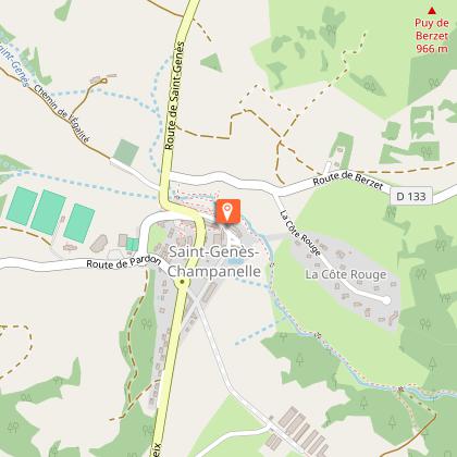
Starting point
Additional information
Tips
We recommend that you follow the tour using the Mikhes app, which guides you step by step to simplify your discovery. Download the app at the bottom of the page and start your tour.
Updated by
Clermont Auvergne Volcans - 02/06/2026
www.clermontauvergnevolcans.com
Report a problem
Location complements
Road access to L'Escapad' - 1 chemin du Château - 63122 Saint-Genès-Champanelle Le Bourg.
From Clermont-Ferrand, take the N89 via Beaumont, Ceyrat, Saulzet-Le-Chaud then Theix.
Continue on the D90 to Saint-Genès-Champanelle Le Bourg or via Royat, Charade, Manson then Thèdes (D90).
Open period
From 01/01 to 31/12 daily.
Contact
Phone : 04 43 76 26 81
Email : lescapad@clermontmetropole.eu
Website : https://www.clermontmetropole.eu/en/bouger-se-divertir/a-la-decouverte-de-lagglo/tourisme-sportif-et-loisirs-de-pleine-nature/
Environments
Forest location
Mountain view
Guidebook with maps/step-by-step
1. From Escapad', pass behind the church and take the crosswalk. At the town hall, go to the signpost and follow the signs for "Chatrat". Turn left and walk past the cemetery.
2. At the road, turn right for 300 m, then fork left after the horse quarry. At the crossroads, turn right onto the main path to "Manson".
3. At the wash-house, turn left towards "Laschamps".
4. At the top of the climb, turn right to the road, then left along the road to "Chapelle Saint-Aubin".
5. After the chapel, continue along the road for approx. 500 m, then take the path on the left (follow the yellow circles).
6. At the top of the climb, turn right, then left at the crossroads, direction "Saint-Genès-Champanelle". At the next crossroads, take the path on the right towards "Fontfreyde".
7. Turn right. Go downhill and around the church, then turn left uphill towards "Saint-Genès-Champanelle". At the bottom of the descent, turn left, following the forest (do not cross the road).
8. At the end of the climb, come back down and take the first path on your right, then go straight on. Walk past the sports complex to the town hall and back to Escapad'.
Data author
