Alert
Alerts
Le Châtelet-en-Brie : The Castle Path


Description
A pleasant stroll through Le Châtelet-en-Brie, a small town in the Brie region overlooking a spring which is said to have been the reason for its original settlement. Certified by FFRandonnée.
Description of the route :
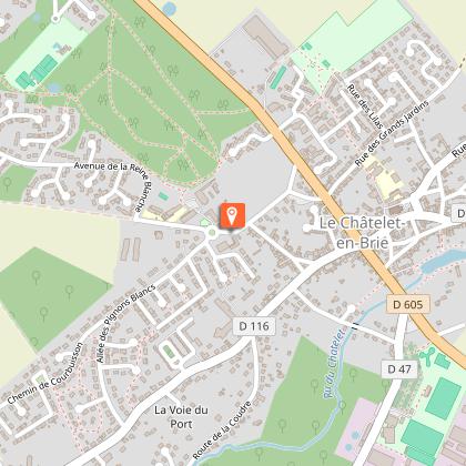
1. With the castle in front of you, leave to the left, then right at the roundabout. Pass the car park on the right and take the woodland path on the same side. Take the path on the right and cross the residential area. Cross the RD605 and follow Rue de la Loge aux Bergers. At the bend, go straight ahead into the path, then turn right into the Passage de la Peupleraie. It crosses a street and leads onto Rue des Grands Jardins.
2. Make a right then a left and, by the Passage des Marjolets, pass in front of the church to reach the RD213. Turn right, then left into Rue Saint-Hubert. Turn left into Rue Baudra, which continues as Rue des Dames de Poissy. Go down on the right by the path running along the washhouse.
3. Go around the basin on the right, cross the bridge over the Châtelet stream and go uphill on the right. Cross the RD605 and go up Route de Féricy. Pass the cemetery and the wastewater treatment plant opposite the sports complex, then go down the woodland path on the right. When you reach the road, make a right then a left and cross the bridge over the stream again.
4. Climb the grassy path on the right up to Rue de Fontaine-le-Port. Make a right then a left and enter the grassy path, then another path on the right passing between houses. Leave the path on the left, make a wide left curve and cross a paved road. Then leave the left path and, following a right curve, reach the paved Allée des Pignons Blancs. Turn right, then left into Chemin des Guyottes. Turn left into the path, which continues as a paved road. After a right-angle turn to the left, rejoin Allée des Pignons Blancs.
5. Turn right twice, leave the road on the left, and continue along the gravel path which makes a right-left turn, continuing as a paved passage. Turn left into Rue de Rambouillet, then left into Rue Saint-Augustin, and finally left into Rue du 19 Mars 1962 to return to the starting point.
Municipality crossed : Le Châtelet-en-Brie
Distance : 5 km - Duration : 1h40 - Marked trail : Yellow - Difficulty : Easy
Access to the map : www.cirkwi.com/fr/circuit/353267-le-chatelet-en-brie-le-chemin-du-chateau
Technical Information
Altimetric profile
Starting point
Points of interest


Additional information
Environments
In the country
Updated by
Communauté de Communes Brie des Rivières et Châteaux - 29/04/2026
www.briedesrivieresetchateaux.fr
Report a problem
Open period
All year round daily.
Contact
Email : seine-et-marne@ffrandonnee.fr
Website : http://www.randonnee-77.com/
