Short race to take a little height and observe the village of Notre Dame de Bellecombe and its famous bulb-shaped bell tower!
This route is taken clockwise.
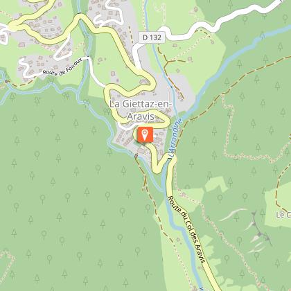
DEPARTURE: Tourist Office.
ROUTE: From the Tourist Office, go up towards LE REGUET TELESKI, then LE TERRET. Then turn right on the climb to reach LE MANS. From there, descend to REGUET (1386m). Then go down to HAUT DE CHELOUP, then CHELOUP. Continue on LES NANTETS, and finally return to L'ÉGLISE in the village center of Bellecombe.
4.5 km
|
max. 1400 m
min. 1122 m
280 m
280 m
| |||
The 9th edition of the Arly Cimes Trail will take place on June 23, 2024 !
La Giettaz offers the the 3rd edition of its outdoor sporting event set against the backdrop of Mont Blanc and the Aravis mountains ! With 4 itineraries, 44km, 28 km, 16km and 10km, this is a playground boasting 360° panoramic views, making it an event not to be missed!Bambée, to communicate a great distance ! Choice of 4 itineraries : * La Bambette : 10 km with 600m of uphill climb Start in the village - la Gardette - Le Col des Aravis - L'Alpage des Plachaux - Psamo - Foiroux – Finish in the village * La Petite Bambée : 16 km with 920m of uphill climb Start in the village - la Gardette - Le Col des Aravis - L'Alpage des Plachaux - Le Chalet du Curé - Blanchet – Finish in the village * La Bambée : 28 km with 1780m of uphill climb Start in the village - Le Plan - Alpage de Pététruy - Col de Niard - Tour du Croisse Baulet - Col du Jaillet - Les Crêtes- La Tête du Torraz – Finish in the village. * La Grande Bambée : 44 km with 2700m uphill climb Same start as La Petite Bambée + Le Plan - Alpage de Pététruy - Col de Niard - Tour du Croisse Baulet - Col du Jaillet - Les Crêtes- La Tête du Torraz – Finish in the village. Extras ! - For all levels - Solo or relay (Grande Bambée) - Passage through the alpine pastures - Large space and XXL panoramas This event takes place on mountain routes and weather conditions can change very quickly, so it is compulsory to bring the equipment noted below: * Compulsory equipment : - Mobile phone in working order - Water reserve of at least 0.5 litres - Waterproof jacket with hood (Gore-Tex type) adapted to your size - Survival blanket (140cm x 200cm) * Recommended equipment depending on weather conditions: - Hat, tights, gloves The organisation reserves the right to refuse the start to a competitor who is not sufficiently equipped for the weather conditions.
Duration: between 0h40 and 1h20.
Topo guides references :
Topoguide "Itinéraires Trail Val d'Arly / Beaufortain" on sale in tourist offices.
Stone
Ground
Not suitable for strollers
Phone : 04 79 31 61 40
Email : info@notredamedebellecombe.com
Website : www.notredamedebellecombe.com
Facebook : www.facebook.com/notredamedebellecombetourisme
Twitter : twitter.com/valdarlymtblanc
From 01/06 to 31/10.
Pets allowed on a leash only.
Office de Tourisme du Val d'Arly - 05/02/2024
www.valdarly-montblanc.com
Report a problem
Mountain location