Alert
Alerts
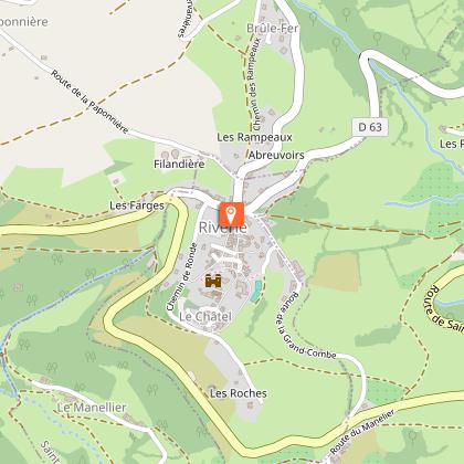
From Riverie to the borders of Bozançon - Monts du Lyonnais - Riverie


IGN cards


Description
Between the Roman aqueduct, the medieval village of Riverie and railway remains, the route also reveals wild valleys and landscapes open to the Pilat. A contrasting journey, between heritage, nature and plunging views of the Bozançon.
You'll love:
• A route punctuated by the remains of centuries past: the Roman aqueduct of Gier, the "medieval" Riverie, and the unfinished construction site of the F.O.L.* railway line at the beginning of the 20th century.
• A challenge dedicated to trail enthusiasts motivated by encounters with stony and slippery paths and steep gradients.
• The variety of landscapes, sometimes very open, facing Mount Pilat, plunging views of the Bozançon plant corridor, the refreshing confluence of the Petit and Grand Bozançon mountains...
• The Bozançon Valley**, occupied by both agricultural activity concentrated on the plateaus and wild environments on its steep slopes.
You'll enjoy it better:
• With the right equipment: sturdy shoes, water, binoculars, etc.
• By stopping in Riverie, listed as a Petites Cités de Caractère®, strolling through the narrow streets and along the rampart walk.
• At the intersection with "les aqueducs de Jurieux," leave the trail briefly and turn left to make the round trip to the Pont de Jurieux bridge and see the remains of the Roman aqueduct of the Gier.
• From autumn to spring, listen to the birdsong and the rivers while walking in temperatures suitable for long hikes.
* F.O.L.: West Lyon Railway
** The Bozançon Valley is listed as a Sensitive Natural Area
A bit of culture:
Riverie
It is the smallest village in the Rhône, only 42 hectares. But, from the Middle Ages to the end of the 16th century, it represented a powerful barony. Its sovereignty being a threat to Lyon, due to its devotion to Protestantism, the stronghold was destroyed and the male population massacred. Today adorned with the Petites Cités de Caractère® label, Riverie charms with the architecture of a town with a homogeneous setting composed of exposed stone houses. The other attraction of the town is its harmonious integration into the landscapes of the Monts du Lyonnais. The rampart walk, the castle terrace where the stump of the Sully lime tree still appears, the market square and its old hospital, or the church, protecting the relics of Saint Ursula are all worth discovering.
Technical Information
Altimetric profile
Starting point
Additional information
Environments
In the country
Village centre
Panoramic view
Updated by
Rhône Tourisme - 24/11/2025
www.rhonetourisme.com
Report a problem
Open period
All year round daily.
Subject to favorable weather.
Contact
Email : contact@montsdulyonnaistourisme.fr
Website :
https://out.ac/LBeqM
https://www.rhone-outdoor.com/fr/
Type of land
Ground
Hard coating (tar, cement, flooring)
Data author
