Alert
Alerts
Snowshoe trail : Col du Lac Blanc
Description
Mountain conditions can change rapidly and may present significant hazards, such as avalanches or snow requiring specific equipment. We therefore advise you to check the trail conditions and any restrictions before setting out.
Here you will discover the type of landscape that you find in the far north. Indeed, whether you go up in altitude in the Alps or in latitude, the vegetation is practically the same.
There is vegetation, but it only grows at ground level, so it becomes invisible when the snow arrives. It becomes invisible when the snow arrives. It is composed of lichens and creeping willows, considered as trees because they produce wood, albeit small, but wood nonetheless! Moreover, under the appearance of an uninhabited place, specific animals adapted to this environment walk the slopes of these spaces despite the complex weather conditions. The mystery of life takes shape despite difficult conditions: snow, wind, strong sunlight. The Pic Blanc (3323m) is the highest point of the ski resort, Pic Bayle, named after the abée Bayle who climbed it for the first time in 1874, is at 3464m and finally, further north, the Etendard (3465m). The highest point of the massif remains however to be discussed because we find on certain maps the Bayle peak as the highest point... quarrel between Isère and the kingdom of Savoy since we are on the edge... On your left is the chalet/cabin of the ski patrollers whose role is to mark out the area, limit the risks of the terrain by signalling cliffs and other dangers. Their role is vast, they are there to rescue you, but also to trigger avalanches and allow the skiers of the domain to evolve in complete safety. Many jobs that are not well known to the public are necessary for the smooth running of a ski area. For example, at night the snow groomers and their pilots work the slopes to guarantee good quality snow. You can see large pipes in the mountains near the slopes. These are called gazex. They are used to prevent avalanches.They are managed remotely. Sometimes before the domain opens, you hear "boom", detonations. The gazex will cause an explosion, a wave which may or may not trigger an avalanche. They are located in strategic places, for example in a corridor overhanging a ski run. The aim is to provoke an avalanche artificially.
Technical Information
Altimetric profile
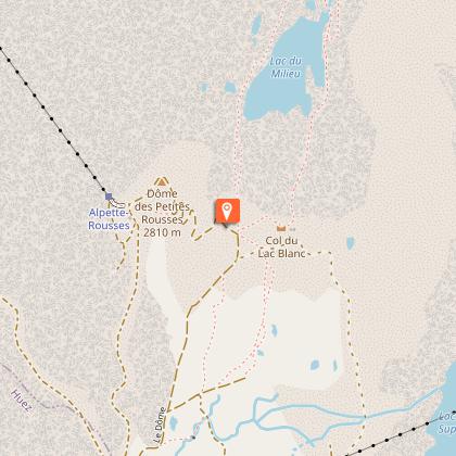
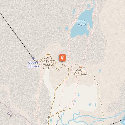
Starting point
Points of interest
Additional information
Contact
Phone : 04 76 80 72 37
Email : info@vaujany.com
Website : https://www.vaujany.com/fr/
Environments
Mountain location
Type of land
Not suitable for strollers
Updated by
Office de Tourisme de Vaujany - 22/12/2025
www.vaujany.com/fr/
Report a problem
Open period
From 11/12 to 19/04 daily between 9 am and 4 pm.
Subject to favorable weather.
Reception complements
All rubbish must be brought back by the hikers. This rule applies along the trail. The forest environment must be preserved, avoid cutting branches or mutilating them.
Tips:
- Make sure that snow does not get into your shoes by using gaiters.
-While snowshoeing:
- Remember to release the heel of the snowshoe! For your information, the back of the foot is sometimes tied up when going downhill when there is a lot of snow.
- Go with poles, essential for balance.
- Don't hesitate to tap your snowshoe with the pole from time to time, it allows to remove some of the snow and thus to lighten your step.
- Foggy glasses are usually a good indicator of too much body heat or too rapid a change in body heat. If this happens, you can reduce your speed, the number of layers of clothing or simply ventilate by allowing cool air to enter under your windbreaker.
Tricky passages
Be careful in case of snowfall to check (with the cashier) if the path is practicable and marked out, in order to know if you can walk this route or if it is better to walk it with snowshoes!
Advice: only do this hike in good weather, the panoramas are grandiose and require good weather. Also, if it is windy, avoid this route as the cable car can stop at any time for safety reasons.
Guidebook with maps/step-by-step
From Vaujany, buy a pedestrian ticket for the Dôme des Rousses at the lift ticket office. Remember to ask the lift desk hosts if the path is passable. Take the cable car up to its stop at l'Alpette, then take the second section of the cable car to the summit: the Dôme des Rousses. You descend, reach the snow, and the marked pedestrian route leaves on your left.
Several return options:
- Take the same route as the outward journey up to the cable car at Dôme des Rousses. It takes about 1h30 to go back up on the same route as the descent.
- Easy option: once you have finished your descent, you arrive at the DMC cable car arrival; you take it on the way down, get off at the next arrival. From here you change buildings to Poutran, another gondola that takes you to Oz station. From Oz station, buy a lift back up with the Alpette gondola, to l'Alpette. Then take the Alpette cable car to Vaujany.
- Difficult option: once you have finished your descent, you arrive at the arrival of the DMC cable car; you take it on the descent, get off at the next arrival. You leave the arrival station, and continue to the left on the pedestrian itinerary that goes down to the Besson lake. From the lake Besson you walk back along the pedestrian route marked with purple markers that takes you to the Alpette; count 2 hours to complete this crossing. Once you arrive at the Alpette, you take the cable car back to Vaujany.
For each of these options make sure you have enough time to get back to the lifts.
Animals
Yes
Data author
