Alert

Alerts

To see around
See more
Open
Close
Show
Show
Show
Show
Show
Show
Show
Show
Show
Show
Show

Oups... It would appear that Cirkwi does not have permission to use your location.

Presentation
Description
Map
Points of interest
Ratings and reviews
See around

Excursion - The Corveissiat grotto and outcrop

Excursion - The Corveissiat grotto and outcrop

Description

LE SENTIER DE LA RECULÉE DE CORVEISSIAT IS TEMPORARILY CLOSED (municipal by-law attached to website).
Public traffic is prohibited between the cave access path and the footbridge, until DECEMBER 31, 2025.

Emblematic of the Jura mountains, the reculées are worlds apart. Setting off along this path and coming face to face with this imposing porch is always spectacular, or following this torrent down to the Rivière d'Ain amidst the moss remains magical.

Site classified as a landscape
Espace Naturel Sensible de l'Ain - ENS
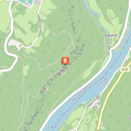
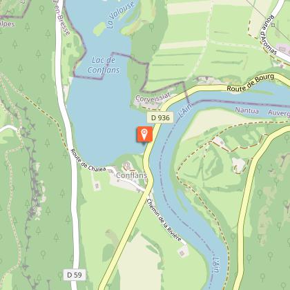
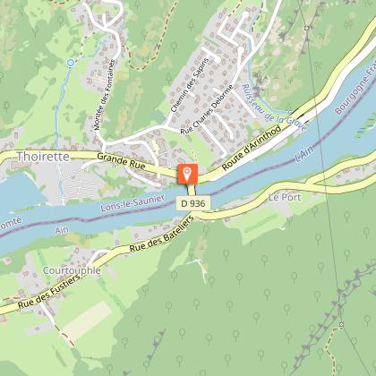
Distance: 6 km
Time: 1h30 - Difference in altitude: 200 m - Marking: Yellow
Route: Go downhill. At the bottom, right for the cave porch. Leave the site by stairs. Descend to the footbridge (waterfalls and cliffs), cross it and join the ain (0h20). After the climb, turn left to the crossroads, then right to return.

Grotto :
The cave can be visited by appointment for groups, or on Wednesdays in summer during guided tours organized by the managing association (Agek).

Alternative departure point: from the boat launch parking lot on the banks of the River Ain.

Technical Information

Walking
Difficulty
Easy
Duration
1h30mn
Dist.
6 km
Show more

Altimetric profile

Starting point

Parking du belvédère Route de Thoirette , 01250   Corveissiat
Lat : 46.238263Lng : 5.486813

Points of interest

image du object

Fontaine-Noire, ENS de l'Ain

On the right bank of the Ain, in a characteristic meander between the villages of Corveissiat and Bolozon, a magnificent riverside site. Impressive color in high water. Pedestrian access from the Cize viaduct.From the viaduct, walk along the River Ain and its fishermen's huts. Next to a small stone hut just a stone's throw from the water, you'll discover a small stream that emerges from the rock to join the Ain. The "Fontaine Noire" is part of the ENS Haute Vallée de l'Ain, which will be awarded the "ENS" label by the Département de l'Ain in 2019. True natural and landscaped jewels of the Ain department, sites awarded the ENS "Espaces naturels sensibles" label are managed in such a way as to preserve the biodiversity they host, and developed for opening to the public (barring exceptions due to the fragility of the environments). Caving : During a survey of the banks of the Ain in 1976, the cave was discovered by speleologists. Robert Durand and Jean-Louis Fantoli explored 402m of drowned conduits up to a narrow laminar. On 05/06/1977, an interclub operation (Daniel Andrès, O.Bigot, Jean-Louis Fantoli and Pierre Licheron) found the continuation in the siphon and led to an open gallery ending in a hopper. The cavity is mainly composed of two parts, characterized by the existence of a siphoning branch downstream and a semi-active part upstream. The entrance basin plunges at -3 to the start of the gallery. After a low point at -7, the drowned corridor (2.5 x 5m), with its surprisingly flat, smooth floor and ceiling, rises again after some 50 m into a collapsed room, partly excavated at low water. Large boulders and slabs of rock block the passage, and thick clay deposits line the floor and walls at this point. Upstream, the conduit submerges completely, plunging to -10m. All along the way, stalagmites and stalactites testify to an exundated phase of the cavity, and remain one of La Fontaine's key sights. 170m from the entrance, a 2m-diameter shaft is carved out of the middle of the gallery, which extends into a 30m-long rolling mill. The shaft gives access at -20 to a lower gallery also linked to the rolling mill by an 8m chimney. Blades of erosion spike up the shaft to 280m, in a room at -18. There are two options: - at the back of the room, high up, a rolling mill at -10m exhales a perceptible current. - To the west, a high diaclase crosses the axis of the room at right-angles and opens out into the open. Halfway down, at -5°, a gallery extends for some 50 m to the open air, 350 m from the entrance. The gallery runs north for 284m. Overflow waters from the underlying circulation flow through it. It develops over a stratum joint (4 x 1.5m), intersected by numerous perpendicular fractures. A 6-metre drop precedes a lake with an impenetrable hopper at its end. Water temperature: 10°C.

- Bourg-en-Bresse destinations - Office de tourisme -
Consulter

Additional information

Environments

In the country
Riverside
Forest location
Mountain view
Village 2 km away
Close to GR footpath
Waterside
Waterfall view

Updated by

Bourg-en-Bresse Destinations - Office de tourisme - 24/11/2025
www.bourgenbressedestinations.fr
Report a problem

Open period

Closed temporarily.

Ratings and reviews

To see around
See more
Open
Close
Show
Show
Show
Show
Show
Show
Show
Show
Show
Show
Show
Caution!
We have no information on the difficulty of this circuit. You may encounter some surprises along the way. Before you go, please feel free to inquire more and take all necessary precautions. Have a good trip! 🌳🥾