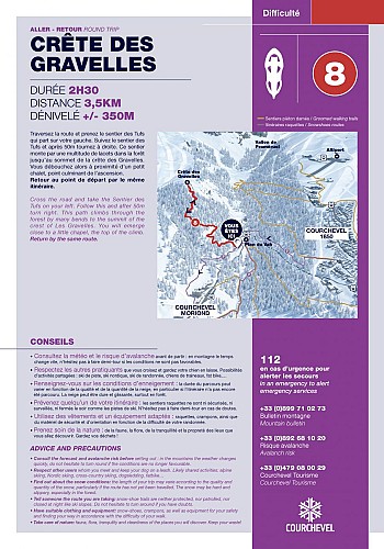
Crête des Gravelles


Description
This walk takes you to the top of a sunny little peak: the ideal spot for a picnic.
Possible access to the starting point with the free shuttles or on foot (from Courchevel 1850 by the itinerary).
From the Plan du Vah, find the start of the Sentier des Tufs, on the other side of the road. Walk on this trail for about 50m and turn left on a small path. This route goes uphill, with lots of turns, to the Gravelles ridge. It leads to a small chalet (private property), peak of the ascent.
Way back by the same itinerary.
Warning: the snow may be hard or icy, depending on conditions.
Technical informations
3.5 km
|
max. 1950 m
min. 1645 m
350 m
350 m
| |||
Accessibility |
Altimetric profile
Starting point
Date and time
- From 01/12/2024 to 30/04/2025 from 09:00 to 17:00
- From 01/12/2025 to 30/04/2026 from 09:00 to 17:00
Additional information
Type of land
Non-groomed itinerary
Contact
Phone : 04 79 08 00 29
Email : info@courchevel.com
Open period
From 01/12 to 30/04 between 9 am and 5 pm.
Access to snowshoe trails is forbidden outside the opening hours of the ski area.
Subject to favorable snow and weather conditions.
Updated by
Courchevel Tourisme - 29/02/2024
www.ski.worldcupcourchevel.com/
Report a problem
Environments
Lakeside or by stretch of water
Forest location
Near shuttle stop
Mountain view
Close to a public transportation
Isolated
Lake 5 km away
Waterside
Data author
