Alert
Alerts
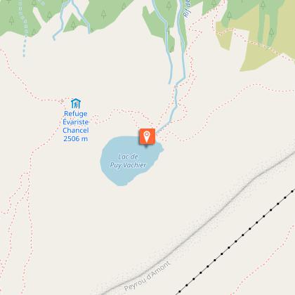
Evariste Chancel refuge and Puy Vachier lake from 2400m


Description
The traverse to the Refuge, via the Puy Vachier lake, offers a beautiful panorama of the alpine pastures and peaks of the valley's southern slopes: the Emparis plateau, the Goléon and Mas de la Grave peaks, the Aiguilles d'Arves and the Trois Evêchés.
From the intermediate station of the Glaciers de la Meije cable cars,
at 2400m, follow the signs to Lac de Puy Vachier and Refuge Chancel.
At the start, the path descends for around 60 metres. At the junction with the path leading down to La Grave, take the left-hand path that crosses the mountainside to the lake.
Then follow the path to the Chancel refuge, which takes about 30 minutes.
Return by the same route.
Technical Information
Altimetric profile
Starting point
Points of interest

Additional information
Environments
Lake view
Mountain view
Updated by
Office de tourisme des Hautes Vallées - La Grave - La Clarée - L'Izoard - 24/06/2025
www.hautesvallees.com/la-grave/
Report a problem
Open period
From 01/05 to 31/10.
Contact
Phone : 04 76 79 90 05
Email : lagrave@hautesvallees.com
Animals
Yes
Data author
