Alert
Alerts
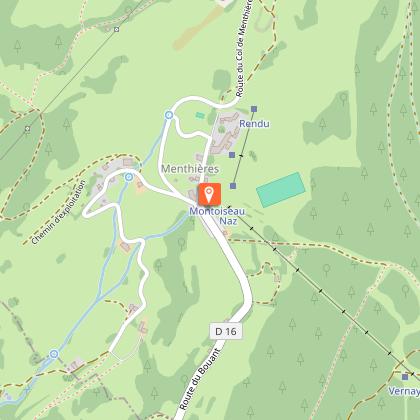
Snowshoe trail from Menthières to La Poutouille
1 alert on this circuit
MONTAIN REFUGE : "CHÂLET DE LA POUTOUILLE":
Visitor alert
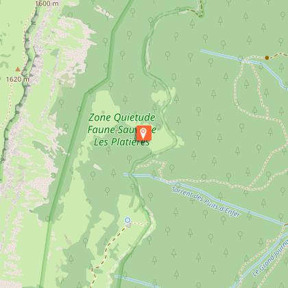
Camping of any kind is prohibited in the Haute Chaîne du Jura. However, camping is tolerated in the immediate vicinity of chalets and refuges open to the public (within a 15-meter radius of the chalet) if they are fully booked. Special case of bivouacs (temporary camping without tents): the Prefectoral Order of October 16, 2017 sets out the conditions for the practice of bivouacs within the Nature Reserve. For more information on the subject, please visit the Haute Chaine de Jura National Nature Reserve website. The refuge is located in a wildlife tranquility zone. It is strictly forbidden to enter this zone between December 15 and June 30, except on marked footpaths.
It is your responsibility to respect the area, to clean up after yourself and to bring back your garbage. Thank you for thinking of future arrivals. The refuge is located in a National Nature Reserve. Please respect the regulations in force.


Description
Follow the Menthières snowshoe trail through snow-covered forests and clearings to an alpine chalet. Once you arrive, enjoy a superb panorama of Mont Blanc, the Alps, Lake Geneva, and the Hautes-Combes du Jura.
This is a round-trip route that takes you through the wild and unspoiled landscape typical of the Haute Chaîne du Jura. Follow the marked trail through the forest and then across the mountain pastures to reach the Chalet de la Poutouille, an unmanned refuge that makes for a great stopping-point in the heart of nature.
Along the way, there are many viewpoints: the Grand Crêt d'Eau dominates the landscape at the start, then gradually magnificent panoramas of Mont Blanc, the Alps, the Lake Geneva basin and nearby Geneva reveal themselves.
This peaceful trail, away from the crowds, immerses you in the sweeping scenery of the Jura ridges. The route passes through the Haute Chaîne du Jura National Nature Reserve, a protected area where nature rules: stay on the marked trails and follow the regulations.
Please note that from December 15 to June 30, the trail crosses a wildlife quiet zone. Use of the trail is only allowed on condition that you stay strictly on the marked route and do not stray from it.
Technical Information
Altimetric profile
Starting point
Points of interest

Additional information
Contact
Phone : 04 50 28 09 16
Website : https://www.paysdegex-montsjura.com
Open period
Closed temporarily.
Environments
Forest location
Mountain location
In a nature reserve
Type of land
Non-groomed itinerary
Topo guides and map references
Map references :
3330OT - BELLEGARDE-SUR-VALSERINE and 3328OT - CRÊT DE LA NEIGE
MAP: Hiking in the Pays de Gex and the Haute Chaîne du Jura. On sale at the Tourist Office
Updated by
Office de Tourisme du Pays de Gex - 16/04/2026
www.paysdegex-montsjura.com
Report a problem
Reception complements
▶Preparing for a winter outing in the mountains
Before setting off on a hike, snowshoe or ski tour, there are a few key steps you need to take to ensure your safety and that of your companions.
▶1. Check the weather and conditions
Check the general and local weather conditions (changes during the day, fog, wind, etc.).
Find out about the quality of the snow (powdery, icy, blowing snow, etc.).
Make sure there is no precipitation forecast.
▶2. Prepare your route
Study the approach, the height of the route and the access conditions.
Estimate the journey time and look for possible escape routes.
Use reliable resources: IGN maps, GPS, topographical guides.
▶3. Assess the risks
Seek advice from local professionals: guides, refuge wardens, tourist offices, etc.
Take account of natural hazards (avalanches, fog, slippery terrain, etc.).
▶4. Inform your friends and family
Share your itinerary, departure and return times.
Give the number of participants and their telephone numbers.
Indicate the vehicle(s) you will be using and where you will be parking.
▶5. Check your equipment
-Never go off on your own.
-Use equipment that is suitable for the activity, properly adjusted and in good condition.
-Take along :
-Headlamp
-Complete first aid kit
-Survival blanket
-Mobile phone + external battery
-Water bottle + snacks
-Wear clothing suited to the weather (cold, wind, damp...).
-Appropriate hiking boots, including for children.
-Walking poles recommended for balance and comfort.
▶6. In the event of a problem
In Europe, dial 112, the free emergency number.
Guidebook with maps/step-by-step
(1) Start: park at the Menthières station parking lot. Head left, then, at La Gentiane restaurant, climb up to the right to reach the top of Menthières.
(2) From this point, cross the road and take the path that passes under the undergrowth. It veers to the right and crosses again a hundred meters further on. The route continues along a few trees and joins a parking lot.
(3) At the Col de Menthières, take the path to the right of the car park and go around the farm to follow the bottom of the valley to a place called La Grange Velue.
(4) Follow the route into the forest and, at the first intersection, turn right towards “La Pelaz / La Poutouille,” still following the yellow PR markings. The trail mainly crosses through woods.
(5) At the track, take the hairpin bend to the left, then negotiate a hairpin bend to the right. Continue to a new intersection at the entrance to the Haute Chaîne du Jura National Nature Reserve.
(6) Turn left and follow the path towards La Pelaz / La Poutouille. The marked trail leads to the Combe de la Pelaz.
(7) Climb up to the right on a steep trail to reach a viewpoint overlooking the Grand Crêt d'Eau and the Retord plateau. The path alternates between forest, undergrowth, and valleys.
(8) Arrive at the unguarded Poutouille refuge, an ideal place to take a break in a wild and isolated setting.
Return via the same route to the parking lot.
Animals
No. Dogs strictly forbidden in the Nature Reserve
Data author
