Alert
Alerts
Snow track to Les Montronds
Description
A superb hike over the crests, with breathtaking views of Mont-Blanc, the Alps, Lake Geneva and the Hautes-Combes du Jura... before a beautiful descent to the heart of the resort.
This snowshoe trail, accessible via the Mont-Rond cable car (pedestrian ticket required), takes you on a hilly route offering spectacular 360° views. On one side, you can admire the Alps in all their majesty, with Mont Blanc in the background, the Lake Geneva basin and Geneva at your feet. On the other, the panorama opens up onto the Hautes-Combes and the entire Jura mountain range.
This ridge hike alternates between gentle ascents and descents in a peaceful atmosphere. Ideal for lovers of wide open spaces, you can immerse yourself in the snow-covered countryside before descending leisurely back to the heart of the resort.
Technical Information
Altimetric profile
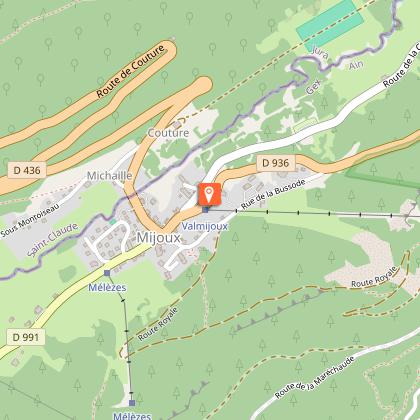
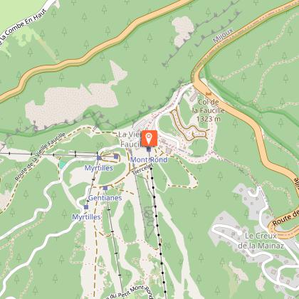
Starting point
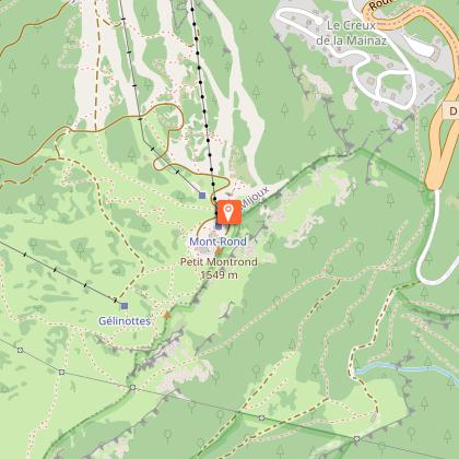
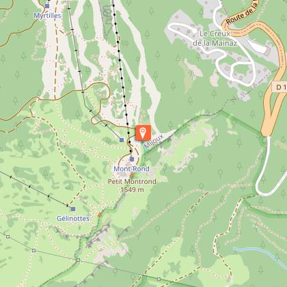
Points of interest
Additional information
Open period
From 31/12 to 31/03 daily.
Itinerary to be followed during the snow season until 1 May.
Updated by
Office de Tourisme du Pays de Gex - 19/05/2026
www.paysdegex-montsjura.com
Report a problem
Environments
Forest location
Ski resort
Mountain location
Contact
Phone : 04 50 28 09 16
Website : https://www.paysdegex-montsjura.com
Type of land
Non-groomed itinerary
Topo guides and map references
Map references :
3327ET - MOREZ LES ROUSSES
TRACK LINES: From the Monts Jura
TRACK LINES: From the ENJ
MAP: Hiking in the Pays de Gex and the Haute Chaîne du Jura. On sale at the Tourist Office
Reception complements
▶Being well prepared for a winter outing in the mountains
Before setting off on a hike, snowshoe or ski tour, a few key steps are essential to ensure your safety and that of your companions.
▶Check the weather and conditions
Check general and local weather conditions (daytime trends, fog, wind, etc.).
Find out about the quality of the snow (powdery, icy, blowing snow...).
Make sure no precipitation is forecast.
▶. Prepare your itinerary
Study the approach walk, the height of the route, and the access conditions.
Estimate the time it will take to complete the route, and locate any possible escape routes.
Use reliable resources: IGN maps, GPS, topo-guides.
▶ Assess the risks
Seek advice from local professionals: guides, refuge wardens, tourist offices, etc.
Take natural hazards into account (avalanches, fog, slippery terrain, etc.).
▶ Inform your friends and family
Share your itinerary, departure and return times.
Give the number of participants and their telephone numbers.
Indicate the vehicle(s) used and the parking location.
▶. Check your gear and equipment
Never set off alone.
Use equipment that is suitable for the activity, well adjusted and in good condition.
▶Take along:
Headlamp
Complete first-aid kit
Survival blanket
Cell phone + external battery
Water bottle + snacks
Wear clothing adapted to the weather (cold, wind, humidity...).
Appropriate hiking shoes, including for children.
Walking poles recommended for balance and comfort.
▶ In the event of a problem
In Europe, dial 112, the free emergency number.
Tricky passages
Safety instructions:
Beware of snow cornices in the Grand Montrond sector
Guidebook with maps/step-by-step
(1) Start: At the upper station of the telecombi, turn right.
(2) Descend slightly and go around the TNT antenna to cross over to the other side.
(3) Continue downhill into a small hollow, then climb back up on the left, following the markers.
(4) Very quickly, the panorama opens up onto the Alps and Mont Blanc: a first breathtaking view.
(5) The trail climbs gently to a plateau that is often snow-free due to the wind.
(6) From this point, descend to a signpost.
(7) Turn left and follow the sign for "Grand Montrond ."
Alternative route: continue straight on towards the Crozat chalet to avoid the summit and go directly to the resort.
(8) A steady climb takes you to the summit of Grand Montrond, offering a second exceptional view of the Jura.
(Caution: do not approach the cornices, as they may be unstable.)
(9) Then begin the descent towards La Faucille.
(10) The trail joins the Crozat chalet, then crosses a ski slope (be careful).
(11) Continue straight ahead as you enter the forest.
(12) Cross a footbridge before descending onto a wider trail.
(13) Follow this trail to reach the heart of La Faucille resort.
Animals
Yes
Data author
