Alert
Alerts
Hiking: Le Creux de l'Envers


Description
Partly bordering the Journans river, the trail passes through the canyon of the mysterious Portes Sarrazines. This trail, with its varied, verdant landscapes, is set in an unspoilt environment.
This pleasant hike, accessible from April to November, follows the waters of the Journans. The “Au fil du bois” discovery trail highlights human activities linked to the forest and water. Finally, the Portes Sarrazines (Saracen Gates), framing a gorge formed by the river, take their name from a local legend: during the middle ages the inhabitants of Gex took refuge behind these stone gates during the Saracen invasions. The trail offers a diversity of landscapes, alternating between forest paths, roads and steep pathways.
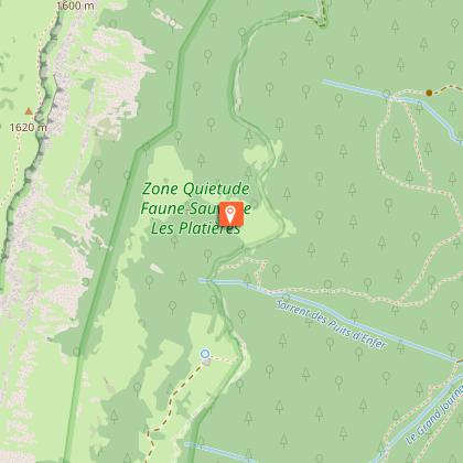
The route takes in the heart of the Haut-Jura Regional Nature Park, and part of the Haute Chaîne du Jura National Nature Reserve: a protected, unspoilt area to be explored with respect.
Good to know - Protected area
Part of the route passes through the Haute Chaîne du Jura National Nature Reserve, which is subject to special regulations:
Dogs are not allowed, even on a lead.
Camping in tents prohibited.
Please respect these rules to preserve the richness of this exceptional environment.
Technical Information
Altimetric profile
Starting point
Points of interest
Additional information
Contact
Phone : 04 50 28 09 16
Email : contact@paysdegex-tourisme.com
Website : https://www.paysdegex-montsjura.com
Open period
All year round daily.
Subject to favorable weather.
Environments
Overview on river
In the country
In a nature reserve
Type of land
Stone
Ground
Hard coating (tar, cement, flooring)
Grit
Not suitable for strollers
Topo guides and map references
Topo guides references :
Hiking in Pays de Gex and the Haute Chaine du Jura: on sale at Pays de Gex tourist agencies: 9€.
Map references :
3327ET - MOREZ LES ROUSSES
Updated by
Office de Tourisme du Pays de Gex - 19/05/2026
www.paysdegex-montsjura.com
Report a problem
Reception complements
▶ This route crosses the Haute Chaîne du Jura National Nature Reserve. Please respect the regulations.
The rules include the following:
Dogs are strictly forbidden, even on a lead.
Plant picking and mineral collecting are also prohibited.
▶ Before setting off :
Check the general and local weather forecast, and make sure there's no precipitation.
Find out about the approach route, the height of the itinerary, the time it will take to complete the climb, and any possible escapes (IGN map, GPS, topo-guide, etc.).
Evaluate possible risks by asking mountain professionals, mountain huts and gîtes.
Inform someone close to you of your objective, and contact them again in the event of any changes: departure and return times, number of participants with telephone numbers for each, vehicle(s), parking, etc.
Avoid setting off alone, and use equipment that is suitable for the activity, adjusted and in good condition: headlamp, complete first-aid kit, survival blanket, etc.
In the event of a problem, call 112 (European emergency number).
Guidebook with maps/step-by-step
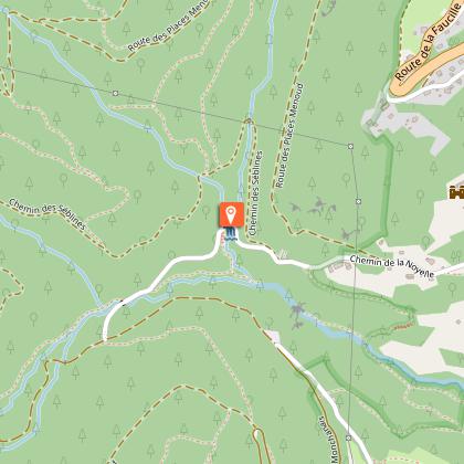
(1) From Place Perdtemps in Gex, take Avenue Perdtemps towards the RN5. Cross the road, then join Chemin des Combes, which rises gently above the town.
(2)At the first intersection, continue straight ahead. The climb continues through meadows and woods to the last houses on the edge of town.
(3)At the end of the road, it becomes a dirt track at a place called “Le Moulin”. Follow this path to the next fork in the road.
(4) Turn left towards “Hauts de Galas”. The path rises gently, skirting the border of the Nature Reserve. The undergrowth gradually becomes more sparse.
(5) The path briefly leaves the nature reserve to join a forest road. Follow this track, which meanders quietly before re-entering the Reserve, and reaching a forest parking lot, a discreet landmark.
(6) Continue along the forest road around the side of the mountain. It soon leads to the Creux de l'Envers, a peaceful green setting.
(7) Keep to the right, cross the Journan stream, then follow the path as it descends slightly before ascending over rocky steps. The atmosphere becomes wilder.
(8) At Les Séblines, continue along the forest road, then follow the signs for Portes Sarrazines, a remarkable geological formation and natural gateway to the Jura landscape.
(9) Just before you reach it, turn right to cross a footbridge over the Journans river. Enjoy the mysterious, majestic site of Portes Sarrazines, nestled in the heart of the forest.
(10) Return by the same route: cross the footbridge again, then continue straight on past it to join the Chemin des Combes, which descends gently towards Gex and Place Perdtemps, bringing the hike to a close.
Animals
No. Dogs are strictly forbidden in the Haute Chaîne du Jura National Nature Reserve.
Data author
