Alert
Alerts
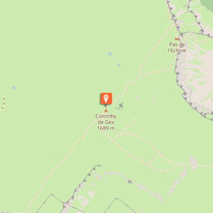
Hiking: Colomby de Gex from Le Pailly


Description
From the summit ridges enjoy panoramic views of Lake Geneva and the Alps before plunging into the Branveau circus.
This itinerary on the Haute Chaîne du Jura promises immersion in an unusual, wild and unspoilt setting. After reaching the Crozat mountain pasture and the Colomby de Gex summit at 1688m, the descent begins via the Branveau circus before reaching the chalet des Platières. This varied and sometimes technical trail, promises a great adventure! .
The Colomby de Gex pylon was originally built in Paris, then transported and erected in Gex in 1907. An inscribed stone commemorates Fernand Fluckiger, a Swiss aviator who was killed in a plane crash on June 2, 1932.
The route takes in the heart of the Haut-Jura Regional Nature Park, and part of the Haute Chaîne du Jura National Nature Reserve: a protected, unspoilt area to be explored with respect.
Good to know - Protected area
Part of the route passes through the Haute Chaîne du Jura National Nature Reserve, which is subject to special regulations:
Dogs are not allowed, even on a lead.
Camping in tents prohibited.
Please respect these rules to preserve the richness of this exceptional environment.
Technical Information
Altimetric profile
Starting point
Points of interest
Date and time
- From 16/05/2026 to 30/11/2036
- From 16/05/2027 to 30/11/2037
Additional information
Open period
From 16/05 to 30/11 daily.
Subject to there being no snow.
Subject to favorable snow and weather conditions.
Updated by
Office de Tourisme du Pays de Gex - 19/05/2026
www.paysdegex-montsjura.com
Report a problem
Environments
Panoramic view
In a nature reserve
Presence of livestock and guard dogs
Contact
Phone : 04 50 28 09 16
Website : https://www.paysdegex-montsjura.com
Type of land
Rock
Stone
Ground
Grit
Not suitable for strollers
Location complements
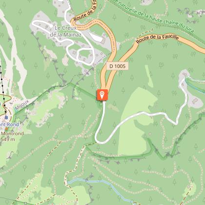
The Pailly parking lot is 2 km from the Col de la Faucille in the direction of Gex.
Topo guides and map references
Topo guides references :
Hiking in Pays de Gex and the Haute Chaine du Jura: on sale at Pays de Gex tourist agencies: 9€.
Map references :
3327ET - MOREZ LES ROUSSES
Reception complements
▶ This route crosses the Haute Chaîne du Jura National Nature Reserve. Please respect the regulations.
The rules include the following:
Dogs are strictly forbidden, even on a lead.
Plant picking and mineral collecting are also prohibited.
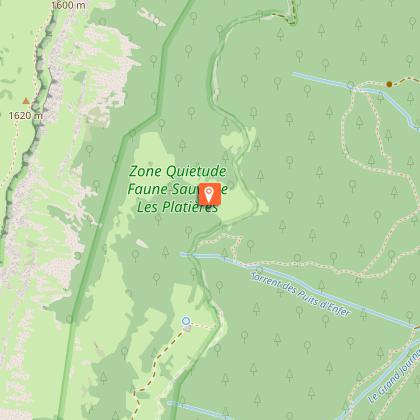
The path crosses a Quiet Zone, closed from 15 December to 15 May: access is forbidden during this period.
▶ Before setting off :
Check the general and local weather forecast, and make sure there's no precipitation.
Find out about the approach route, the height of the itinerary, the time it will take to complete the climb, and any possible escapes (IGN map, GPS, topo-guide, etc.).
Evaluate possible risks by asking mountain professionals, mountain huts and gîtes.
Inform someone close to you of your objective, and contact them again in the event of any changes: departure and return times, number of participants with telephone numbers for each, vehicle(s), parking, etc.
Avoid setting off alone, and use equipment that is suitable for the activity, adjusted and in good condition: headlamp, complete first-aid kit, survival blanket, etc.
In the event of a problem, call 112 (European emergency number).
▶ The Patou or guard dog: what attitude should you adopt?
When out hiking, it's not uncommon to come across flocks of sheep or goats guarded by guard dogs known as patous. These dogs, formidable against predators such as wolves, bears and lynxes, can frighten hikers with their barking.
The patou protects flocks in total autonomy. Its main role is to deter intruders and alert the shepherd. Raised among the ewes from an early age, he learns to protect them at all times, often in groups.
▶ To avoid problems with a patou:
Identify grazing areas before setting off.
Keep your distance and go around flocks if possible.
In the event of an encounter, stay calm, turn back slowly or stop to let the dog sniff you out.
Don't try to pet or feed the animals, avoid sudden movements, don't run, and avoid taking photos.
▶ For runners:
Do not run when approaching a herd.
Take off your headphones to hear the dog's barking.
By adopting these behaviors, you'll be able to cohabit serenely with guard dogs on your hikes.
Guidebook with maps/step-by-step
(1) From the Pailly parking lot, turn right onto the small forest road which descends for around 100 metres. Then take the path that climbs to the right, towards the ridges. The path winds through the forest and eventually reaches the mountain pastures via the junction with the Vie de Chaux trail (closed from December 1 to May 15, and to be used with caution in late winter).
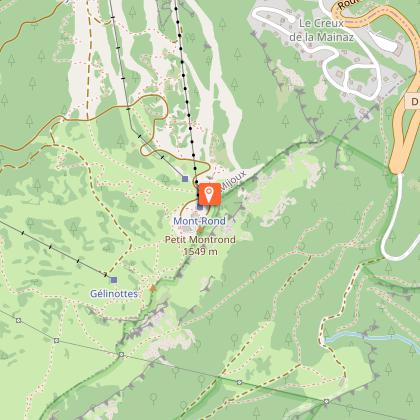
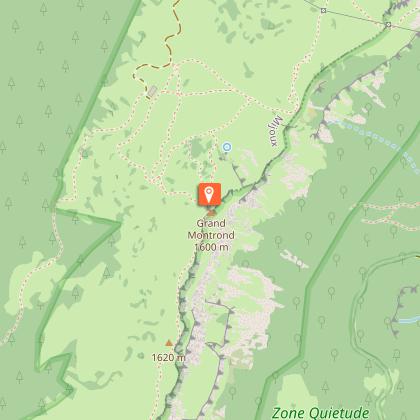
(2) The path ends at a crow's-foot (junction with the crest path). Turn left onto the GR and follow the signs for “Grand Montrond / Colomby”.
(3) The trail follows the crest of the ridge through undulating countryside, offering a fine view of the Lake Geneva basin. There's a short climb before reaching the summit of Grand Montrond.
(4) From Grand Montrond, descend towards Chalet du Crozat, then turn left and continue on the white and red GR towards Colomby de Gex.
(5) Follow the GR to a crossroads, then leave the main path and descend to the left through a mountain pasture, following the yellow markers on the ground towards Chalet de Branveau.
(6) A turnstile marks the entrance to Col de Branveau. Climb above the chalet to a small pass at the foot of Pas de l'Echine.
(7) Switch to the other side via a descent that becomes more technical in the undergrowth, in the Creux de l'Envers forest.
(8) At the Chemin Neuf intersection, turn left towards the Chalet des Platières.
(9) Continue along a wide path until you reach the Place Menoud intersection.
(10) At this fork, take the path on the left that leads to the Chalet de la Quible.
(11) From the chalet, head to the Pailly car park, the starting point of the loop.
Animals
No. dogs strictly forbidden.
Data author
