Alert
Alerts
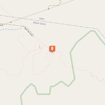
Bois du sud Trail


Description
Site of an old logging operation, the Bois du Sud is home to a beautiful humid forest. While walking along the two trails, hikers can discover some remarkable species such as the gum oak, the houp or the kaori.
With luck you will also be able to observe humid forest bird; on the other hand, make sure you bring enough water with you because there is no source of water on the heights of the Bois du Sud
D - Car park: head south to reach a wooden bridge located between tall trees. No dogs allowed.
1 - History of the site, fauna and flora panel (GPS: 681 553 – 7 547 055; alt. 194m): cross the bridge. Turn left and then, immediately afterwards, take the path which enters the bush on the right (south-west). It winds through the shrubs and gradually begins a zigzag climb among the blocks of hardened laterite soil (a few steps sometimes). Continue climbing to reach a lookout.
2 - Information panel (GPS: 681 376 – 7 546 743; alt. 261m) (located near an old prospecting shaft): the track then begins a slow descent in a thalweg filled with rough shrubby vegetation, then rises slightly, passing through the bush to an open shoulder.
3 - Lookout (GPS: 681 531 – 7 546 634; alt. 274m): towards the Bois du Sud forest. Continue the descent and join a good dirt track. Turn left (north-west) and then, a little further on, turn right (north-east) towards the narrow path that enters the humid forest.
4 - Humid forest information panel (GPS: 681 611 – 7 546 943; alt. 203m): the path meanders through dense stands of tall trees, on the left bank of the creek which "gurgles" in the half-light.
5 - Kaori information panel (GPS: 681 666 – 7 546 955): shortly after the panel, the route descends to the creek by means of a short staircase. Cross to reach the opposite bank (the water level is variable). Follow the right bank upstream for a short distance and come to a clearing where there are shelters. Cross straight ahead of the entire developed area to reach the right track which leaves the site. Turn right (east) into the forest.
>This part is shared with the GR® NC1 (double marking: red and white; yellow).
Go past the last camping pitches and, after a bend, turn right to find a narrower path that winds through the forest.
6 Water hole information panel (GPS: 681 869 – 7 546 792; alt. 208m): continue on the marked trail towards the south-west, then cross a maintained ditch. The path then leads to a good red dirt track where the GR® NC1 passes. Turn left and return to the start.
Text by Jean Francis Clair
Technical Information
Altimetric profile
Starting point
Additional information
Open period
Closed temporarily.
Updated by
Sud Tourisme Nouvelle-Calédonie - 12/06/2025
Report a problem
Environments
Lake view
Close to GR footpath
In a nature reserve
Contact
Phone :
+687 98 57 51
+687 46 06 25
Type of land
Rock
Stone
Ground
Grit
Not suitable for strollers
Location complements
Situation : direction Yaté. Then, 100 m after the entrance of the Blue River Provincial Park, turn right on a straight track. Drive 1,6 km on the red earth to reach the entrance of the site. Telephone booth. Paid and controlled entrance.
Parking : (GPS : 681 566 - 7 547 055 ; alt. 194 m)
Topo guides and map references
Topo guides references :
Description sheet available for download (province-sud.nc) or in paper version in tourist organizations.
Map references :
Map DITTT n° 25 Prony
Reception complements
FFrandonnée® grading
* Effort: Fairly easy IBP 25 (light blue)
* Technical difficulty: fairly easy (light blue)
* Risk: Fairly low (light blue)
* Overall score: fairly easy (light blue)
Tricky passages
No water on the heights of the South Woods. The crossing of the creeks is not always done on dry foot.
Animals
No. Most of this route passes through protected areas where pets are not permitted.
