Alert
Alerts
The Prorel summit
Description
The Prorel summit overlooks Puy Saint Pierre and Briançon. On arrival, there's a superb panoramic view of the Serre Chevalier valley, the Ecrins and the Rochebrune peak.
Detailed itinerary :
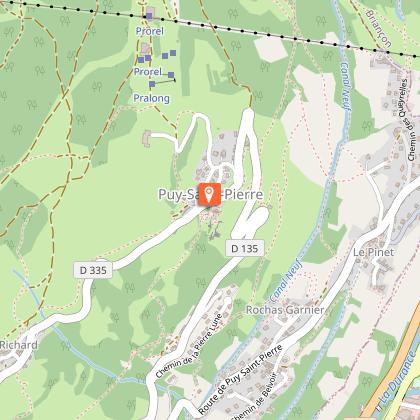
From the church square in Puy-Saint-Pierre, take the small tarmac road opposite the church, which climbs two hairpin bends to reach the Pralong farm.
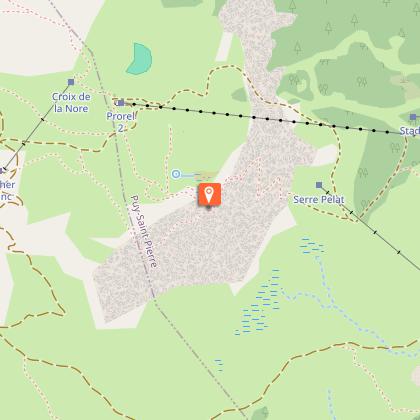
A few metres past the farm, take the wide track. After about 100 m, take the footpath rising to the left, signposted "Notre-Dame des Neiges et ses oratoires". The narrow path leads to a track: on the right, you can see the Prorel ski lifts. Ignore the right-hand track and follow it to the left for around 100 m.
On the right, pick up the narrow path leading to the first oratory: Sainte Marie (alt: 1700m). At this first oratory, continue straight ahead to cross the track a second time and reach the Etoile du Matin oratory (alt: 1840m).
Follow the path to the left to reach the Serre Pelat ski lift, which the path passes under once. Ignore the left-hand path in the direction of the combes, and pass under the ski lift again, near the Saint-Joseph oratory (Alt: 1950). The path then continues to pass a 4th oratory-fountain of Notre-Dame de Bon Rencontre, then bends to the left to pass under the ski lift one last time.
Once you've left the ski lift, the path crosses a flat area (damp in places) to pass the 5th oratory, Saint Hubert. The route ends up winding up a steep slope in scree until it reaches the chapel on a ledge.
At the chapel, take the path just behind. It crosses the wide ski slopes to the end of the ski lifts, then winds its way up to the summit.
Return by the same route to the oratory-fountain of Notre-Dame de Bon Rencontre. Once there, take the left-hand path, which gradually descends to join the Prorel trail that leads to Ferme de Pralong, before returning to the church.
Technical Information
Altimetric profile
Starting point
Steps
Date and time
- From 15/05/2026 to 15/10/2026
- From 15/05/2027 to 15/10/2027
Additional information
Open period
From 15/05 to 15/10 daily.
Subject to favorable snow and weather conditions.
Updated by
Office de tourisme des Hautes Vallées - La Grave - La Clarée - L'Izoard - 15/04/2026
www.hautesvallees.com/la-grave/
Report a problem
Environments
Mountain view
Panoramic view
Mountain location
Village -2 km away
Contact
Phone : 06 07 07 31 08
Email : izoard@hautesvallees.com
Website : https://www.hautesvallees.com/lizoard/
Facebook : https://www.facebook.com/Izoardtourisme/
Type of land
Stone
Ground
Not suitable for strollers
Location complements
From the N94 marking the entrance to Briançon, turn left at the traffic lights towards Puy-Saint-André via the D35.
Cross Le Pinet to reach the Place de l'Église in Puy-Saint-Pierre.
Topo guides and map references
Map references :
Carte IGN TOP 25 n° 3536 OT Briançon - Serre Chevalier - Montgenèvre
Reception complements
During the summer season, this hike can be done from the Prorel Télécabine arrival station (3km return - 190m ascent).
Data author
