To see around
See more
Open
Close
Show
Show
Show
Show
Show
Show
Show
Show
Show
Show
Show

Oups... It would appear that Cirkwi does not have permission to use your location.

Description
Map
Points of interest
Ratings and reviews
See around

Hiking & Jeep Trail: Mayères from Burzier

Hiking & Jeep Trail: Mayères from Burzier

Description

Beautiful family hike with panoramic views of Mont-Blanc and the Fiz.
This trail is easier but more frequented by 4x4s. There is a footpath at the end of the parking lot.
At the finish, 2 refuges welcome you.
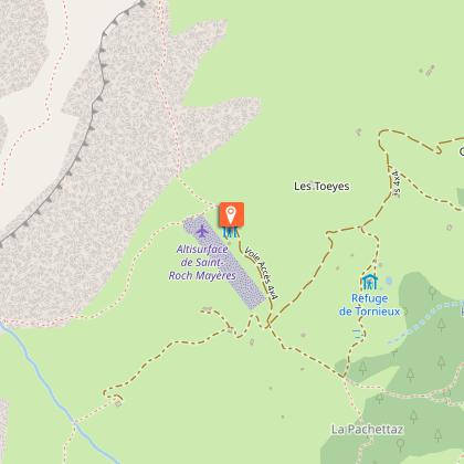
Departure: Burzier car park
This 4x4 path is semi-shaded at the start, then more open towards the top of the pasture. Accessible to 4x4 every day without restrictions.

1. start this route by the motorable path at the entrance to the car park.
2.the slope is a little steep at the start, but only around 500 m (15 min)
2.You then arrive at a crow's feet with the direction of Doran in front of you and to the left that of Mayères
3.take the left direction, direction Mayères, always by the jeepable path
4.the path is semi-shaded and emerges at times to give you a glimpse of the Mont-Blanc massif
5. After 1h30 to 2h of walking you will arrive at the 1st mountain refuge and restaurant, Le Tornieux
6. then 10 min above, you will find the mountain refuge and restaurant of Mayères with its famous altisurface: the last one in Haute-Savoie.

Many other hiking routes start here:
The Arête des Saix, the valley of Doran, the Broken Finger, Lanchéron, the Four Heads, the Ovens, the Split Stone, the Vallée de Coeur, ...

Return by the same route, round trip (possibility to take the forest route if you wish)

Walking time is approximate and does not include break times.

Go on a safe hike!
This description allows you to orient yourself globally but does not replace a hiking map at 1/25000 or other topoguides that you can find in your tourist office! In Sallanches, our Office of Guides & Accompanists also offers a wide choice of outings accompanied by mountain professionals providing you with complete expertise on the environment and alpine nature, think about it!

Whatever your hike, check the weather before heading out.
Remember to take cereal bars, sufficient water, sunglasses, sunscreen, a small first-aid kit, as well as clothes suitable for your outing depending on the season in your backpack. and the forecast forecast.

Technical informations

This circuit was updated on: 05/05/2024
7.8 km
3 h 45 mn
min. 99999 m
595 m
595 m
Public : Family

Altimetric profile

Starting point

départ : parking de Burzier route de Doran , 74700 Sallanches
Lat : 45.957296Lng : 6.610079

Points of interest

image du object

Tornieux Refuge

As a family or with friends, experience the welcoming atmosphere of a quality refuge located in the heart of a lush mountain pasture with generous meals on offer. In winter, experience our sledging evenings: a Savoyard dinner and tobogganing.

Parking de Burzier 6700 route de Doran 74700 SALLANCHES (adresse du départ de la randonnée ) 546 route de Passy 74700 Sallanches
- Sallanches TOURISME -
Consulter
image du object

Restaurant d'altitude Refuge du Tornieux

With family or friends, soak up the warm atmosphere of a quality mountain restaurant in the heart of a lush mountain pasture at an altitude of 1450m. In the winter, experience our sledge nights: walk up to the restaurant, enjoy a Savoie-style dinner and sledge back down. Booking recommended.Meals and birthday celebrations, banquets, meetings, receptions.... With a terrace facing the Mont Blanc. Possible Transportation of people up to the refuge if needed. Accessible by 4x4 and a shady path for walkers away from the road. Possible walks in the area: Vallée du coeur, Doran, quatre Têtes

route de Mayères Burzier 74700 Sallanches
- Sallanches TOURISME -
Consulter
image du object

Traditionnal and quality cooking. Situated in Sallanches, the "Refuge de Mayères", nearby the Aravis chain, has a unique sight on the Mont-Blanc chain, with one the the last landing zone of Haute-Savoie.

Alpage de Mayères 74700 Sallanches
- Sallanches TOURISME -
Consulter
image du object

Restaurant d'altitude Chalet de Mayères

Traditionnal and quality cooking and also savoyard specialties. Nearby the Aravis chain this refuge has a unique sight on the Mont-Blanc, with one of the last landing strips of Haute-Savoie.-trash economies -renewable energy

alpage de Mayères 74700 Sallanches
- Sallanches TOURISME -
Consulter
image du object

L'Alpage de Mayères (mountain pasture)

Beautiful pasture in the heart of the Aravis range with breathtaking views over the Mont-Blanc and Fiz ranges.

départ : parking de Burzier route de Doran 74700 Sallanches
- Sallanches TOURISME -
Consulter
image du object

Altisurface de Mayères

Dernière altisurface de Haute-Savoie ouverte à tous les usagers aéronefs utilisant la fréquence montagne 130.0. Au pied des Quatre Têtes le site vous offre une magnifique vue sur les 3 massifs : Mont-Blanc, chaine des Fiz et Aravis.Le refuge de Mayères possède la dernière altisurface de Haute-Savoie. Cette piste est réservée à des pilotes chevronnés possédant une qualification montagne . Infos pour les pilotes LAT : N 45 57 00 // LONG : E 006 35 10 ALT : 5118 ft - Radio: 130.00 Réglementation : du 1 Juillet au 31 Aout En semaine : 2 atterrissages maxi par avion après 9h Le Week-end : 1 atterrissage par avion après 9h

plateau de Mayères 74700 Sallanches
- Sallanches TOURISME -
Consulter

Additional information

Updated by

Office de Tourisme de Sallanches - 22/04/2024
www.sallanchesmontblanc.com
Report a problem

Open period

All year round.

Subject to favorable weather.

Contact

Phone : 04 50 58 04 25

Email : tourisme@sallanches.com

Website : www.sallanchesmontblanc.com

Facebook : www.facebook.com/sallanchesmontblanc

Data author

32 Quai de l'Hôtel de ville 74700 74700 - SALLANCHES France

Ratings and reviews

To see around
See more
Open
Close
Show
Show
Show
Show
Show
Show
Show
Show
Show
Show
Show