Alert
Alerts
Walking itinerary: the village of Vallon and the Giffre dykes
Description
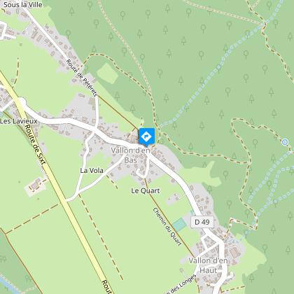
The village of Vallon is split into two parts: Vallon d’en Bas and Vallon d’en Haut. Its inhabitants are called the Cavoêrus. This village constituted a civil parish from 1730. On June 22, 1811, it was attached to Samoëns by an imperial decree.
Duration: 1h30
Elevation: 17 meters
Type of terrain: Roads and trails
Special recommendation: none
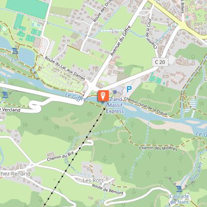
Starting point: The Grand Massif Express (GME) cable car park
Special difficulty: none
Map reference: itinerary n ° 4 topoguide Haut Giffre Valley.
Go along the Giffre to a footbridge spanning the Clévieu. Cross then take the path on the left, which takes you on the old dykes of Giffre. The path, in the undergrowth, soon joins the Giffre which we follow to the Revé bridge.
Leave the bridge on your right and take, a few meters further, the path which leaves on the left and crosses the plain of Vallon. Facing you overlooks the Criou mountain and to the right, at the bottom of the valley, the Commune mountain.
Cross the road and continue with the one just opposite which leads to Vallon d'en Haut.
In the village turn left. Observe the fountain, dated 1873 and carved from a single block of stone. Continue to Vallon d'en Bas. The chapel founded in 1636 is placed under the name of the Saints: Jacques, Philippe and Joseph, in thanks for their protection during the plague epidemic which raged in 1630.
Shortly after the chapel, turn right in front of a large pool. The road leads to a crossroads. Turn left, follow the Clévieu stream then cross the departmental road.
At the second bridge, change banks and continue along the Clévieu to find the footbridge taken on the outward journey. Continue on the path and return to the gondola parking lot.
Itinerary for guidance only.
Technical Information
Altimetric profile
Starting point
Additional information
Updated by
Office de Tourisme de Samoëns - 29/06/2026
www.samoens.com
Report a problem
Environments
Overview on river
Mountain view
Forest location
In the country
Village -2 km away
Tips
Walk that allows you to discover the village of Vallon (Vallon from below / from above), the chapel, fountain and emblematic sculptures of Samoëns.
Open period
All year round daily.
Type of land
Suitable for all terrain strollers
Ground
Grit
Contact
Phone :
04 50 34 40 28
04 50 34 46 02
Email : infos@samoens.com
Website :
http://www.valleeduhautgiffre.fr/
http://www.valleeduhautgiffre.fr
Topo guides and map references
Topo guides references :
Topo ‘50 randonnées en vallée du haut giffre’ Patrice Gain, on sale in the valley's shops.
Map references :
IGN TOP 25 - 3530 ET Samoëns map - on sale at the tourist office and in shops. Montagnes du Giffre hiking map - CCMG - on sale at the tourist office.
Animals
Yes. Dogs on a leash.
Data author
